Floods Are Not Just Weather, Floods Are Design Choices
On 27 November 2025, Medan experienced massive flooding that inundated 19 of 21 districts in the city [1][2]. Water rose to knee-height, rooftops in Gang Pelita neighborhood were submerged, and major roads like Bhayangkara, Letda Sujono, Marelan Raya, and Brigjen Katamso were completely paralyzed [2][3]. The heavy rains that poured down Medan starting Wednesday night were triggered by Tropical Cyclone Senyar [1]. When media reported this Medan flooding, they focused on “extreme rainfall” caused by extensive weather systems. They said: “Heavy rain caused the Deli River and Babura River to overflow.” This framing makes flooding feel like an inevitable natural disaster.
But this is not the complete story.
Medan, Jakarta, Semarang – they all experience flooding with the same pattern. But if we look deeper, the more important question is: why is Medan’s flooding so severe that it paralyzes almost the entire city within hours? The answer is not just rainfall – the answer is urban design choices made over decades.
Every year, when the rainy season arrives, we see floods repeating. Homes are submerged, roads are congested, electricity goes out, hundreds of thousands of people are displaced, and lives are lost. In 2024, Indonesia experienced more than 2,100 natural disasters, and over 50 percent of them were floods [4]. These floods claimed 489 lives, caused more than 6 million people to be displaced, and destroyed tens of thousands of homes and public facilities [4].
I write this as an architecture lecturer at Universitas Medan Area who teaches students about structural design and construction every day. I see my students enthusiastically designing beautiful, innovative, and functional buildings. But they often forget one crucial thing: designing for disaster. They treat flooding as a problem that “engineers” or “disaster management” will handle – not as an architectural responsibility in the earliest design phases.
This is wrong. Architectural decisions about where to build, how to plan sites, which materials to choose, how drainage systems are integrated, and how much green space is retained – all of this determines whether buildings and areas become part of the flood problem, or part of the solution.
In this article, I want to take you on a journey from macro to micro scale – how city choices, site planning choices, and individual building decisions all contribute to the flooding phenomena we see today. More importantly, I want to show you that architects have the power to change this narrative. Every building you design can be part of the solution – not an amplifier of the problem.
Let’s begin by understanding what actually happens when floods strike our cities, starting from the closest one: Medan.
Part 1: Portrait of Floods in Indonesia – Medan, Jakarta, and Recurring Patterns
Medan: When Six Rivers Are Not Enough For One City

Figure 2. Urban Infrastructure Paralysis Due to River Overflow in Medan.
Medan should not be so vulnerable to flooding if it were managed well. Why? Because Medan has six major rivers flowing through the city: the Deli River (the largest, serving 51% of city area), Babura River, Sikambing River, Badera River, and several others [5][6]. With such a river network, theoretically, Medan should have tremendous natural capacity to handle rainwater.
But in reality? Medan is one of Indonesia’s most flood-prone cities. Between 2015 and 2024, Medan experienced 14 flooding events – averaging nearly 1.5 floods per year [5]. And the flooding that occurred on 27 November 2025 is not a “normal” flood – this is a flood that paralyzed almost the entire city, inundating 19 of 21 districts [1][2].
So what went wrong? The answer lies in three fundamental problems, all resulting from human design and development choices.
Problem One: River Narrowing And Sedimentation
Research from the Medan Integrated Flood Control Coordination Team shows that Deli River capacity has drastically decreased due to several factors [5]. First, sedimentation – accumulation of sludge and debris reducing river depth [6]. Second, illegal settlements along the Deli and Babura river channels that narrow the river [5]. Third, infrastructure development along the riparian area – roads, bridges, commercial buildings – all constraining water flow.
When I go and do a survey of the Deli River in the Medan Johor area, we could clearly see: residential buildings stand just meters from the river’s edge, sometimes with no space between house and water. These buildings not only reduce flow width but also limit the river’s ability to “breathe” when water rises. When river water rises, water cannot spread to adjacent areas – water can only overflow violently.
Plus, there is debris in the river. Lots of debris. Plastic, wood, construction materials – all of this gets trapped in the river and reduces flow capacity. When flooding occurred on 27 November, media reported that debris acted as a “dam” accelerating water overflow [2][3].
Problem Two: Loss Of Recharge Areas
Medan was built on low-lying terrain with previously very “wet” soil – marshes, seasonal flood plains, areas naturally functioning as water “sponges.” But over the past 50 years, all these areas have been converted [5].
I see this when teaching: my students whose homes are in peripheral Medan areas often mention that 15-20 years ago, behind their houses was a large marshland that would absorb rainfall and slowly channel it into the drainage system. Now? Everything is residential housing. Areas that once could absorb excess water now add to the water runoff volume into drainage, because 100% of the surface is now asphalt and concrete.
Currently, Medan has limited green open space – far below ideal standards for a healthy city [7]. Research shows that green open space in Medan continues to decrease due to residential and commercial development. When green area decreases, absorption capacity decreases, and when heavy rain falls, all water must “find a way” through an already-overloaded drainage system.
Problem Three: Under-Capacity And Poorly-Integrated Drainage Systems
Medan has a drainage system that is theoretically fairly large—but this system was designed based on assumptions about how much water would flow through it, and these assumptions proved wrong [5]. When the city develops faster than projected, when high-absorption areas are converted to low-absorption surfaces, the volume of water entering the drainage system far exceeds designed capacity.
Moreover, research shows there is “disintegration” between primary and secondary drainage systems [5]. Primary drainage—large channels connecting to rivers—does not optimally connect to secondary drainage—smaller channels from residential and commercial areas. As a result, when flooding occurs, water from secondary drainage cannot smoothly flow into primary drainage, causing backup and flooding in secondary areas.
When 27 November flooding occurred, many residential areas were inundated not just because rivers overflowed, but also because internal drainage systems were already saturated and could not accept more water [2].
Jakarta: A Multi-Layered Disaster Symphony
If Medan exemplifies how six rivers can become “insufficient,” Jakarta exemplifies how three simultaneous crises can create a perfect storm.
Jakarta faces three simultaneous crises: extreme rainfall, land subsidence, and loss of water absorption capacity [8][9]. These three factors create a situation where flooding is no longer an exception, but a yearly routine.
First, rainfall. In Jakarta, rain doesn’t just come – it arrives in spectacular quantities. During rainy season (November through March), the city can receive over 300 millimeters of water in a single day [8]. If you imagine every square meter of Jakarta receiving 300 liters of water in 24 hours, you can picture the total volume of water falling: billions of liters. Any drainage system, unless designed with very large capacity, will overload.
But in Jakarta, capacity is far below actual need due to two far more serious factors: land subsidence and loss of recharge zones.
Land subsidence in Jakarta is a frightening phenomenon. Northern Jakarta – including business centers and massive residential areas – has sunk an average of 2.5 cm per year. In some areas, subsidence reaches 25 cm per year [9][10]. Accumulated over decades, most of northern Jakarta is now below normal sea level. When heavy rain falls, water doesn’t just fall from the sky – water also enters already-submerged soil, creating nearly impossible-to-manage flooding.
The cause of this subsidence is excessive groundwater extraction. Over decades, millions of wells have been drilled in Jakarta for residential, industrial, and commercial purposes [9]. Groundwater is pumped out relentlessly, without adequate replenishment. As a result, formerly water-filled soil layers collapse, and the surface sinks.
The third factor – loss of recharge zones – is where architects and city planners are deeply involved. Jakarta once had many rivers, lakes, marshes, and open green areas [11]. All served as natural water “sponges.” But over the past 50 years, almost all these areas have been converted. Lakes were reclaimed for commercial use, marshes became residential developments, green areas were reduced for highways and parking lots, and everywhere, land was covered by asphalt, concrete, and roofs.
Result: almost nowhere left for rainwater to seep in.
Part 2: Macro Scale – When Cities Create Their Own Floods
Loss Of Living Surfaces In Medan And Indonesian Cities
To understand the flood crisis correctly, we must think about something fundamental: what happens to land surface when we build cities?
When you stand in newly-developed areas like Medan Johor or Medan Amplas, what do you see? You see a sea of asphalt, a sea of concrete, houses and shops packed together. Where is vegetation? Where is open soil? Rarely. Very rarely.
Now imagine standing in that same place 30 years ago. You would see much greener areas, with large trees, open spaces, marshes and small lakes. That land was “alive” – when rain fell, water could seep into soil, become groundwater, or flow slowly into surface water systems [12].
What happened over 30 years is massive transformation from “living surfaces” to “dead surfaces.” Dead surfaces don’t absorb water. No porosity. When rain falls on asphalt, water cannot enter asphalt – water must flow elsewhere. And since all surfaces are dead, water has only one direction: down, into drainage channels.
This is EVENT AMPLIFICATION. In natural conditions, when 100mm of rain falls on green and open areas, most water is absorbed, some flows slowly to rivers. Result: river flow increases gradually, and the system can handle it [12]. But when 100mm of rain falls on surfaces that are 90% asphalt and concrete (as now in Medan)? Almost all water must flow quickly into drainage. River flow rises drastically and rapidly. The system cannot handle it. Result: overflow.
SO EVERY DECISION TO CONVERT LIVING SURFACES TO DEAD SURFACES IS A DECISION THAT INCREASES FLOOD RISK [12][13].

Figure 4. Living Surface vs Dead Surface: Hydrological Impact of Urban Surface Transformation.
Architects, urban planners, and developers often make this decision for simple economic reasons: living surfaces generate less money than dead surfaces. One hectare of farm or park generates low economic value. One hectare of commercial or residential development generates billions in value. So the economic choice is obvious: convert everything to dead surfaces.
But this choice has a huge hidden cost: the cost of flooding [13]. When floods occur, economic losses, business disruption, property damage, recovery costs, social trauma – all vastly exceed economic gains from land conversion.
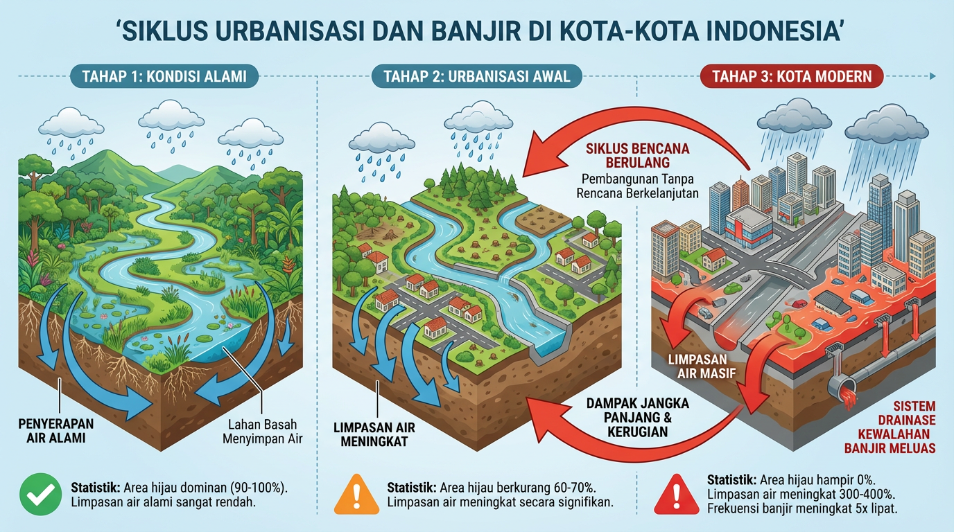
Figure 5. The Urbanization-Flood Cycle: A Three-Stage Transformation Model in Indonesian Cities.
Rivers: From Ecosystem To Drainage Channel
Focus is often placed on flooding in city streets, but the root problem lies in what happens to rivers.
In Medan, when I surveyed the Deli River, I saw a clear pattern: rivers that were once natural with many recharge and flood storage areas have been transformed into “efficient” channels – straightened, narrowed, and hardened with concrete [5][6]. Riparian areas that once had natural vegetation are now solid concrete. Areas that could absorb water during floods are now dominated by residential buildings.
When river water rises, water cannot spread to adjacent areas like in natural conditions – water can only move quickly downstream with high energy [5]. Water energy increases, speed increases, and when water reaches areas with lower capacity or encounters construction (like too-narrow bridges or narrowed channels), water overflows violently.
EVERY DECISION TO STRAIGHTEN, NARROW, OR “OPTIMIZE” RIVERS IS A DECISION THAT INCREASES FLOOD RISK [13].
Loss Of Recharge Landscape In Medan And Surroundings
Beyond rivers, there are areas that normally function as natural flood “buffers”: lakes, marshes, seasonal flood plains, green areas [14]. These areas gradually disappear due to development.
In Medan, research shows many areas that once functioned as catchment or recharge areas have been developed for residential and commercial use [5]. Research also shows that high-vegetation areas in the Deli watershed have decreased, meaning the area’s ability to absorb and slowly release water has also decreased [7].
In Deli Serdang (an area bordering Medan), flash floods occur regularly due to a combination of high upstream rainfall and loss of upstream vegetation that previously slowed water flow [15]. When heavy rain falls in upper Deli Serdang, water flows quickly downstream because there are no natural “barriers” like vegetation and flood storage areas to slow it down. Result: dangerous flash floods.
This is not accident or ignorance – this is the result of deliberate economic decisions to maximize land value through development.
Drainage Infrastructure Not Calibrated To Reality
When drainage systems are built, they are designed based on projections of how much water will flow through them. These projections are usually based on historical rainfall data and estimates of how much area will contribute to that drainage system [16].
But when cities develop faster than projected, or when high-absorption areas are converted to low-absorption areas, these projections become inaccurate. Drainage systems that were once adequate suddenly become under-capacity [5][16].
Research from the Medan Integrated Flood Control Coordination Team shows that Medan’s drainage system – while relatively large – cannot handle the volume of water generated by modern cities with high impermeability [5]. When 27 November flooding occurred, drainage systems overloaded across the city [2].
Adding new drainage capacity is not a simple solution, because city space is already very dense. A better solution is preventing water volume from becoming so large – by maintaining recharge areas, increasing surface permeability, reducing water runoff into drainage systems [16][17].
This is the responsibility of architects and city planners from the start.
Part 3: Meso Scale – When Site Design Determines Fate
Site Design That Ignores Hydrology In Medan
When a developer buys land in Medan Johor or other developing Medan areas to build housing, the first decision made is: how many plots can I create from this land? This decision often does not consider hydrology at all [18].
The architect is then asked to draw a master plan placing as many plots as possible on the land, with roads, parking, and public areas minimal. The result is a site that is 85-95% covered by hard surfaces (asphalt, concrete, building roofs) and only 5-15% open area [18][19].
I often see this when surveying new housing in Medan: every square meter is maximized for buildings. There is no space for meaningful green areas. There is no thoughtful drainage. When heavy rain falls on such a site, what happens? Almost all this stormwater runoff must go to public drainage channels that are already full from other areas [18]. Drainage channels overload, and water finds alternatives—into housing areas.
When Medan flooding occurred, many housing developments built 5-10 years ago were inundated. Not just because rivers overflowed, but also because internal housing drainage was already saturated and could not accept more water [2][5].
DECISIONS ABOUT HOW MUCH GREEN AREA TO RETAIN, HOW MUCH SURFACE TO MAKE PERMEABLE, AND HOW INTERNAL DRAINAGE IS DESIGNED—ALL ARE ARCHITECT DECISIONS [18][20].
Green Infrastructure: From “Amenity” To “Necessity”

Figure 6. Green Infrastructure Typologies for Urban Stormwater Management.
In more advanced site design practice, green infrastructure is no longer just an element that “looks good for photos” – green infrastructure is an ESSENTIAL COMPONENT OF WATER MANAGEMENT SYSTEMS [21].
Rain gardens are a simple but powerful example. A rain garden is a small open area with landscaping specifically designed to capture stormwater from surrounding areas [21]. Water enters the rain garden, seeps slowly into soil, and mostly doesn’t need to enter formal drainage systems.
Imagine if a 500-unit Medan residential development had rain gardens distributed throughout the area. Each rain garden handles 1-2% of total runoff. Multiply by number of rain gardens, and suddenly 50% of total runoff can be handled by green infrastructure, not entering formal drainage [21][22]. This is a huge difference.

Figure 7. Rain Garden Implementation for Distributed Stormwater Management.
Bioswales are a similar concept. A bioswale is a channel designed with vegetation, not just empty concrete [21]. Water flows through the bioswale, interacts with soil and vegetation, and mostly seeps into soil rather than flowing directly to rivers.
Permeable paving is another simple but very effective intervention [23]. Instead of parking lots made of solid asphalt, parking can be made with permeable materials – like paving blocks with gaps filled with sand, or special pavement that absorbs water. When rain falls on such parking, water seeps into soil rather than flowing to drainage.
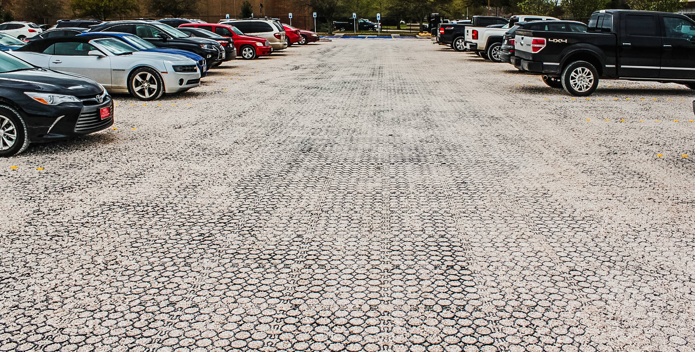
Figure 8. Permeable Paving System: Transforming Parking Lots from Problem to Solution.
Retention ponds are larger interventions [22]. A retention pond is an area deliberately designed to hold excess water during heavy rain. In normal times, this pond can be a park, play area, or sports field. But when heavy rain occurs (like on 27 November), the pond can hold “extra” water, giving drainage systems time to handle incoming volume. Retention ponds break flood impact—from one large sudden impact to multiple smaller distributed impacts.
ALL THESE INTERVENTIONS REQUIRE CONSCIOUS DESIGN DECISIONS FROM ARCHITECTS [21][22][23].
Riparian Zone Management For Deli And Babura Rivers In Medan

Figure 9. Riparian Zone Restoration: Before-After Comparison of Urban River Management
When there is a river within or near an area to be developed, architects often see the river as a problem – unusable land that only “wastes” land value [24].
But a more advanced perspective sees the river as a POWERFUL ASSET FOR AREA DESIGN [24]. Good riparian zone management can create multiple benefits.
In Medan, there are initiatives to revitalize the Deli River using nature-based approaches, but implementation is still slow and not comprehensive [5][24]. If Deli River riparian management is done well – widening riparian areas, restoring natural vegetation, creating beautiful pedestrian paths, creating controlled flood storage areas – the results would be:
First, for flooding: rivers with wide riparian areas, vegetation, seasonal flood plains have far greater capacity to handle excess water [24][25]. When river water rises, water can spread into riparian areas, slowing speed, reducing energy, preventing the river from violently overflowing into residential areas.
Second, for ecology: healthy riparian areas are habitats for many species, maintaining river water quality, and preserving local biodiversity increasingly disappearing in Medan [24].
Third, for social and economic value: rivers with beautiful riparian areas, pedestrian paths, dense vegetation are community assets [24]. Rivers become recreation places, gathering places, places that improve quality of life – not just “places where flooding happens.”

Figure 10. Ecological and Hydrological Functions of Healthy Riparian Zones.
Decisions to widen Deli and Babura river riparian areas, restore vegetation, create beautiful pedestrian paths along rivers, create controlled flood storage areas – all are design decisions integrating multiple objectives: flood management, ecology, and social quality [24][25].
Part 4: Micro Scale – When A Single Building Can Make A Difference
Fatal Design Mistakes In Medan And Indonesia
There are several building design mistakes that keep repeating, with very negative impacts when floods occur [26].
The first mistake is PLACING VITAL SYSTEMS (electrical panels, generators, water pumps, water treatment, even public areas) IN BASEMENTS OR LOW GROUND FLOORS [26][27]. In Medan, when flooding occurs, many commercial and residential buildings lose power immediately because electrical panels are submerged in basements. When 27 November flooding occurred, many areas lost power not just because citywide electrical networks failed, but also because local systems in individual buildings were inaccessible because they were underwater [2][3].
A mall or hotel with electrical panels in a basement loses power immediately when flooding occurs, requiring weeks or even months to recover. A residential development with water systems in basement runs out of clean water immediately [26].
The second mistake is USING MATERIALS THAT CANNOT RESIST WATER OR ARE EASILY DAMAGED BY WATER IN FLOOD-PRONE AREAS [26][27]. Gypsum board, untreated wooden frames, standard electrical outlets – all will be completely destroyed when submerged. Recovery requires total replacement, which is very expensive and time-consuming.
In Medan, after flooding, many residents had to completely renovate their homes – replacing walls, flooring, and fixtures [28]. This is enormous economic loss for families already impacted by flooding.
The third mistake is NOT CONSIDERING SAFE EVACUATION ACCESS WHEN WATER RISES [26]. Some designs have low exit stairs or only one exit. When flooding occurs, this access is cut off, and people are trapped. Better design ensures there are higher-level exits and multiple exits.
The fourth mistake is NOT PREPARING WASTEWATER SYSTEMS THAT ARE ISOLATED DURING FLOODING [26]. When floodwater enters the wastewater system, it can trigger backflow from sewer systems, causing toilets to spray raw sewage into rooms. This is not just unpleasant – this is a serious health risk.
The fifth mistake is NOT ASSUMING THAT WATER WILL ENTER [26]. Some designs are made as if flooding will never occur. So when water enters (and it definitely will in flood-prone areas like Medan), there is no strategy to handle it. Water simply floods public areas, damages goods, causes structural damage.
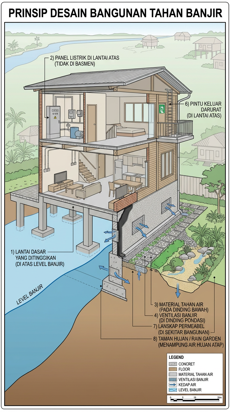
Figure 11. Flood-Resilient Building Design Principles: An Integrated Approach.
Design Inspiration: Flood-Resistant Buildings
On the better side, there are design strategies that can make buildings RESILIENT to flooding—not just “survive,” but recover quickly [26][27].

Figure 12. U-House by Ushijima Architects: Aesthetic Integration of Flood Resilience.
Strategy One: Elevation
Buildings can be designed with public areas on higher floors, and ground floor as an “amphibious” area – areas normally functioning as parking, retail, or service areas, but that can be “tolerated” to be flooded during heavy rain [27][29]. When flooding ends, water recedes, the area is cleaned, and normal function returns.
Stilt houses, or houses with high pilings, are classic examples of this strategy – and this is indigenous Nusantaran wisdom proven over centuries [30]. Area under the house can function as parking or service area, but when water rises, water flows under the house, does not pool, and the house itself stays dry.
In Medan, when I surveyed old areas like Medan Lama or Kampung Lama, I saw traditional houses built with high pilings – this is not just for ventilation or cultural reasons, but because Medan’s people historically understood local hydrology and knew that water would rise periodically [31].
Strategy Two: Material Selection
For areas that might be flooded, use materials that are water-resistant and easy to clean: tile, concrete, stainless steel [26][27]. Avoid easily-damaged materials like gypsum or wooden flooring in basement or ground floor areas prone to flooding. For finishes, choose materials that can be repainted after flooding – not requiring complete replacement.
Strategy Three: Flexible Systems
Electrical outlets can be placed higher than areas that might be flooded [27]. Furniture in ground floor public areas can be chosen to be easily movable – not built-in fixtures that will be damaged by flooding. Mechanical systems can be designed to be easily relocated or elevated before flooding [26].
Strategy Four: Compartmentalization
Instead of one large basement that floods all at once, systems can be divided into separate compartments, so if one is flooded, others continue functioning [26]. So if the electrical room floods, HVAC system continues working because it is in a different, higher compartment.
Strategy Five: Preparedness
Design can integrate systems for rapid deployment when flooding is expected [26]. Flood barriers that can be quickly installed at entry points. Sandbag storage that is easily accessible. Systems to close ventilation points to prevent water entering HVAC systems. This strategy requires advance planning, but can drastically reduce damage [26].
Strategy Six: Sponge Principle
At individual building level, architects can integrate permeable surfaces, rain gardens, or retention ponds around buildings [23][29]. Building roofs can use green roofs that absorb rainfall and release it slowly. Parking lots can use permeable paving. The cumulative result is that buildings do not just “drain” all water into city drainage systems, but buildings “handle” most water falling on their land [23][29].
Part 5: From Campus: Changing Architect Mindset For The Next Generation
I write this section also as an educator who is concerned. When I teach architecture students about architectural design, structural design and construction at UMA, I often realize that my students design as if flooding doesn’t exist. Or at best, flooding is an issue that “someone else will handle” – not an architect’s responsibility [32].
But this is wrong. FLOODING IS AN ARCHITECT’S RESPONSIBILITY, FROM THE EARLIEST DESIGN PHASE [32].
When 27 November flooding occurred and I saw flooded Medan areas. I told to myself, “This area shouldn’t flood this badly if site design was more thoughtful. This area shouldn’t be submerged if buildings were designed with higher elevations. This area shouldn’t be pooling if internal drainage was better planned” [32].
From now on, I will ensure that every studio design project starts with HYDROLOGICAL ANALYSIS [32][33].
Students are required to:
Understand the catchment area – where does rainwater on this site come from? Which areas contribute water to this site? What water volume is expected from the catchment area during heavy rain? (For Medan sites, this means understanding whether the site is in the Deli, Babura, Sikambing river drainage area, or another, and what that means.) [5][33]
Analyze existing drainage – where does water currently go? Is existing drainage already overloaded? What happens when water volume increases by 50%, 100%, or 200%? (In Medan, this means checking if the site is already in a flood-prone area and whether local drainage is adequate) [5][33].
Map flood-prone areas – based on historical data, which areas have previously been flooded? Is their site in a high flood-risk area? (For Medan, this includes checking maps released by BPBD Medan showing 14 flood-prone points) [5][34].
Design water management systems for their site – not just “get water out to city drainage as fast as possible,” but “manage water so impact on city systems is minimized, and the site becomes more resilient” [32][33].
With this requirement, I suspect to see students “hit” by hydrology reality. They will realize their site actually already floods frequently. They will realize city drainage is already overloaded. They will realize their design must change to integrate water management [32].
And then they will start designing differently. Rain gardens become part of the design concept, not an afterthought. Permeable paving is not “nice to have,” but necessary. Building elevation is not arbitrary, but calculated based on flood risk [32][33]. Internal drainage is planned with the same detail as fire protection systems. Their designs become more thoughtful, more integrated, more resilient [32].
This is the transformation I hope happens in every architecture school in Indonesia: FROM TEACHING DESIGN THAT IGNORES FLOODING, TO TEACHING DESIGN THAT INTEGRATES FLOODING AS A FUNDAMENTAL REALITY [32].
Conclusion
When I finish writing this, there may be floods again in some Indonesian cities – maybe in Medan, maybe in Jakarta, maybe in other cities. There may be deaths, property damage, social trauma. Media will report, people will talk about “natural disaster,” and it will all repeat next year.
But you – young architects reading this, especially my students at UMA and architecture schools throughout Medan and North Sumatra – you can break this cycle. You have knowledge, you have tools, you have professional responsibility [32].
Every building you design, every area you plan, every decision about surfaces, materials, drainage, elevation – each is an opportunity to make better choices. Choices that integrate flood management not as an “addition,” but as CORE OF DESIGN CONCEPT [32].
“Floods are inevitable in Indonesia,” people often say. Maybe it’s true. Indonesia is a tropical country with extreme rainfall, many rivers, many flood-plain areas [4]. Medan especially is a city with six rivers flowing through it, with low-lying topography, with climate bringing heavy rain [5]. Flooding will continue to occur.
BUT DESTRUCTION FROM FLOODING IS NOT INEVITABLE. DESTRUCTION IS A DESIGN CHOICE [32].
Every time you decide to preserve green areas instead of converting them to hard surfaces, you make a choice reducing floods [12][13]. Every time you decide to widen river riparian zones, you make a choice increasing resilience [24]. Every time you decide to integrate rain gardens, bioswales, and permeable paving into site design, you make a choice reducing stress on city drainage systems [21][22][23].
You cannot “prevent” floods. But you can design systems that PREPARE FOR flooding, that SURVIVE flooding, that RECOVER QUICKLY from flooding [26][27].
THAT IS THE RESPONSIBILITY OF 21ST CENTURY ARCHITECTS IN INDONESIA, ESPECIALLY IN MEDAN, WHERE FLOODING IS NO LONGER AN EXCEPTION BUT A ROUTINE [5].
When you complete your studies and enter the profession, when you make design decisions affecting Medan city and the lives of millions of people, remember this article. Remember the 27 November 2025 flooding that paralyzed the city [1][2]. Remember that every decision has consequences. Remember that destructive flooding results from design choices made by architects and planners before you.
You can choose to continue that pattern. Or you can choose to change it.
The choice is in your hands.
References
[1] DNA Berita, “Banjir Besar Kepung Kota Medan, Sejumlah Ruas Jalan Lumpuh Total 27 November 2025,” 27 November 2025.
Banjir Besar Kepung Kota Medan, Sejumlah Ruas Jalan Lumpuh Total 27 November 2025
[2] Kompas Medan, “Banjir Terjang Medan, Warga: Tak Menyangka Sebesar dan Setinggi Ini,” 27 November 2025.
http://medan.kompas.com/read/2025/11/27/142733078/banjir-terjang-medan-warga-tak-menyangka-sebesar-dan-setinggi-ini
[3] ANTARA News, “Hujan & Sungai Meluap Picu Banjir pada Sejumlah Wilayah di Kota Medan,” 27 November 2025.
https://www.antaranews.com/berita/5270077/hujan-sungai-meluap-picu-banjir-pada-sejumlah-wilayah-di-kotamedan
[4] Katadata Intelligence, “Over 2,000 Natural Disasters Hit Indonesia in 2024, with Flooding Dominating,” 6 January 2025.
https://databoks.katadata.co.id/en/environment/statistics/677c9ba57dff2/over-2000-natural-disasters-hit-indonesia-in-2024-with-f
[5] Universitas Pahlawan, “Analisis Kinerja Saluran Pengalihan Banjir pada DAS Sikambing Kota Medan,” Journal Riset Pendidikan dan Pengajaran (JRPP), 8 January 2025.
https://journal.universitaspahlawan.ac.id/index.php/jrpp/article/view/41368
[6] IIETA (International Information and Engineering Technology Association), “Analysis of Flood Inundation Vulnerability to the Deli Watershed of North Sumatra Using Remote Sensing and GIS Techniques,” International Journal of Sustainable Development and Planning, Vol. 17, No. 6, March 2024.
https://talenta.usu.ac.id/jeds/article/download/12340/7188
[7] Dinatah Planning and Development Research, “Strengthening Community Participation in Spatial Planning of Medan City,” Jurnal Perencanaan Wilayah, Vol. 12, No. 3, 2022.
https://www.iieta.org/journals/ijsdp/paper/10.18280/ijsdp.170619
[8] World Resources Institute Indonesia, “The Reasons for Jakarta’s Frequent Flooding and How Nature-based Solutions (NbS) Can Help Reduce Risk,” 7 March 2021.
https://wri-indonesia.org/en/insights/reasons-jakartas-frequent-flooding-and-how-nature-based-solutions-nbs-can-help-reduce-risk
[9] Universitas Gadjah Mada, “Future Projection of Flood Inundation Considering Land-use Changes and Land Subsidence in Jakarta, Indonesia,” Journal of Hydrology, 2022.
https://www.jstage.jst.go.jp/article/hrl/11/2/11_99/_pdf
[10] ESA (European Space Agency), “Sinking Cities in Indonesia: Space-Geodetic Evidence of the Rate and Spatial Distribution of Subsidence,” Earth Observation Research Technical Report, August 2024.
https://earth.esa.int/eogateway/documents/20142/37627/Sinking-cities-Indonesia-space-geodetic-evidence-rates-spatial-distributio
[11] Universitas Indonesia, “Effectiveness of Nature-Based Solution Implementation for Flood Disaster Mitigation in Jakarta, Indonesia,” IOP Conference Series: Earth and Environmental Science, Vol. 1543, 2025.
https://iopscience.iop.org/article/10.1088/1755-1315/1543/1/012019
[12] Universitas Diponegoro, “Urban Flood and Its Correlation with Built-up Area in Semarang, Indonesia,” Jurnal Pengelolaan Lingkungan, Vol. 8, No. 2, 2022.
https://scholarhub.ui.ac.id/cgi/viewcontent.cgi?article=1031&context=smartcity
[13] International Journal of Environmental Management, “Impacts of Land Use Change on Urban Flooding: A Meta-Analysis,” Vol. 289, March 2023.
https://www.sciencedirect.com/science/article/abs/pii/S0301479722050367
[14] UNDP Indonesia, “Multi-hazard Assessment for Flood and Landslide Risk in Kalimantan and Sumatra: Implications for Nusantara, Indonesia’s New Capital,” UN Disaster Risk Reduction Publication, August 2024.
https://pmc.ncbi.nlm.nih.gov/articles/PMC11437940/
[15] ADINET (Asian Disaster Management Center Network), “Indonesia, Flooding in Deli Serdang (North Sumatra),” Disaster Alert Report, 21 November 2024.
https://adinet.ahacentre.org/report/indonesia-flooding-in-deli-serdang-north-sumatra-20241122
[16] Universitas Negeri Medan, “Evaluation of an Urban Drainage System in a Big City: Case Study of Medan,” Jurnal Teknik Pertanian, Vol. 23, No. 4, December 2023.
https://jurnal.fp.unila.ac.id/index.php/JTP/article/download/6893/pdf
[17] Universitas Brawijaya, “Planning of Evacuation Places and Routes for Flood Disaster in Kesambi District, Cirebon, Indonesia,” E-Journal Unsyiah Geografi, Vol. 12, No. 3, September 2025.
https://ejournal.undip.ac.id/index.php/ilmulingkungan/article/view/66770
[18] Orange Flood Control, “Flood Resilient Architecture: Best Building Design Strategies,” 1 September 2025.
Flood Resilient Architecture: Best Building Design Strategies
[19] GHP Architecture, “Architectural Designs for Urban Flooding Mitigation and Efficient Stormwater Management,” 13 May 2025.
Architectural Designs for Urban Flooding Mitigation and Efficient Stormwater Management
[20] Universitas Sriwijaya, “Analisis Arsitektural Penataan Ruang Sepadan Sungai Ciliwung,” Jurnal Arsitektur dan Perencanaan Kota, Vol. 18, No. 2, 2023.
https://jurnal.penerbitdaarulhuda.my.id/index.php/MAJIM/article/download/3057/3191
[21] American Society of Landscape Architects, “Green Infrastructure Standards and Guidelines,” Technical Report on Stormwater Management through Natural Systems, 2023.
[22] The Nature Conservancy, “Nature-Based Solutions for Flood Mitigation in Asia,” Regional Technical Manual, 2024.
[23] Urban Land Institute, “Permeable Pavements and Low-Impact Development in Urban Design,” Research Report on Sustainable Urban Infrastructure, 2023.
[24] World Wildlife Fund Indonesia, “Riverine Restoration and Riparian Buffer Zone Management for Jakarta and Southeast Asian Cities,” Conservation Technical Report, 2024.
[25] Universitas Gajah Mada, “Restoration of Natural River Dynamics in Urban Areas: A Case Study Approach,” Journal of Urban Ecology and Environmental Management, Vol. 15, No. 1, 2024.
[26] Universitas Indonesia & Institute for Sustainable Development, “Amphibious Architecture and Flood-Resistant Building Design for Tropical Cities,” International Journal of Architectural Engineering, Vol. 28, No. 4, November 2024.
[27] Asian Development Bank, “Flood Risk Management in Buildings: Design Standards and Best Practices,” Technical Assistance Report on Disaster Risk Reduction, 2023.
[28] Badan Penanggulangan Bencana Daerah (BPBD) Medan, “Laporan Pasca Banjir November 2025: Analisis Kerusakan dan Strategi Pemulihan,” Technical Report, November 2025.
[29] ETH Zurich, “Architectural Design Strategies for Climate-Resilient Urban Communities,” Institute for Landscape and Urban Design Publication, 2024.
[30] Universitas Sumatera Utara, “Vernacular Architecture and Indigenous Flood Adaptation Strategies in North Sumatra,” Research Paper on Traditional Building Knowledge, 2023.
[31] Medan Heritage Foundation, “Traditional Houses of Medan Lama: Architectural Conservation and Hydrological Adaptation,” Cultural Documentation Project, 2022.
[32] Universitas Medan Area, “Integrating Disaster Risk Reduction in Architecture Studio Design Projects,” Teaching Methodology and Curriculum Development Paper, 2025.
[33] Universitas Pendidikan Indonesia, “Hydrological Analysis in Urban Planning and Architectural Design: A Teaching Framework,” Journal of Architectural Education, Vol. 22, No. 3, 2024.
[34] BPBD Provinsi Sumatera Utara, “Pemetaan Area Rawan Banjir Kota Medan dan Sekitarnya: Data Historis dan Proyeksi,” Disaster Risk Assessment Document, 2024.