From Blank Page to Blueprint: A Strategic Approach to Writing Architectural Research Proposals

From an empty page to a structured research blueprint: your thesis proposal is the bridge between curiosity and architectural knowledge.

The architectural thesis proposal is the most critical document in a graduate student’s academic journey, yet it remains one of the most intimidating [1]. It is the moment where abstract curiosity must crystallize into a rigorous research framework, where scattered ideas must coalesce into a coherent argument, and where personal passion must meet academic rigor [1]. For architecture students, this challenge is compounded by the discipline’s unique position at the intersection of art, science, and social inquiry, demanding a research methodology that can accommodate design experimentation while maintaining scholarly credibility [2]. A recent study examining the gap between architectural education and practice identified that 73% of architecture graduates felt inadequately prepared for conducting systematic research, pointing to a significant pedagogical void in research methodology training [3]. This article presents a strategic, step-by-step framework for constructing compelling architectural research proposals, grounded in both established academic principles and the specific demands of design-led inquiry [1].

The Hidden Architecture of Research Logic: Understanding What a Proposal Really Does

Before diving into the mechanics of proposal writing, it is essential to understand the fundamental purpose of this document [4]. A research proposal is not merely an administrative requirement or a formality to be completed before beginning design work; it is the intellectual blueprint that will guide the entire trajectory of your investigation [4]. The proposal serves three critical functions simultaneously: it establishes the urgency and originality of your research question, it demonstrates that you have a systematic and logical plan to address this question, and it projects credible outcomes that will contribute to architectural knowledge [5].

The concept of research urgency deserves particular attention in architectural studies [2]. Unlike disciplines where problems are clearly defined by empirical gaps, architectural research often emerges from the intersection of theoretical inquiry and practical challenges [2]. Your proposal must articulate why this specific investigation matters now – whether it follows emerging trends in computational design, addresses pressing sustainability challenges in tropical climates, or fills a gap in our understanding of vernacular building traditions [6]. This urgency must be justified through both conceptual frameworks and empirical evidence, creating what research methodologists call a “problematic situation” – a demonstrable gap between current conditions and ideal states that demands explanation [7].

The hidden architecture of research logic: how urgency, problem, framework, methods, and outcomes interlock inside a strong proposal.

Constructing the Research Gap: The Foundation of Originality

The identification of a research gap is perhaps the most intellectually demanding aspect of proposal development, requiring systematic analysis of existing literature and critical evaluation of what remains unexplored [8]. In architectural research, gaps manifest across multiple dimensions: theoretical gaps where existing concepts fail to explain observed phenomena, methodological gaps where new techniques are needed to investigate complex problems, and empirical gaps where specific contexts or typologies remain understudied [9].

A robust gap identification process begins with comprehensive literature mapping, utilizing systematic search strategies across multiple databases including Web of Science, Scopus, and discipline-specific repositories [8]. This is not a passive review but an active process of conceptual mapping, where you chart the territory of existing knowledge to identify the frontiers [8]. Advanced techniques such as co-citation analysis can reveal clusters of related research and potential blind spots, while temporal analysis tracks how research themes have evolved over time, identifying dormant areas ripe for renewed investigation [8].

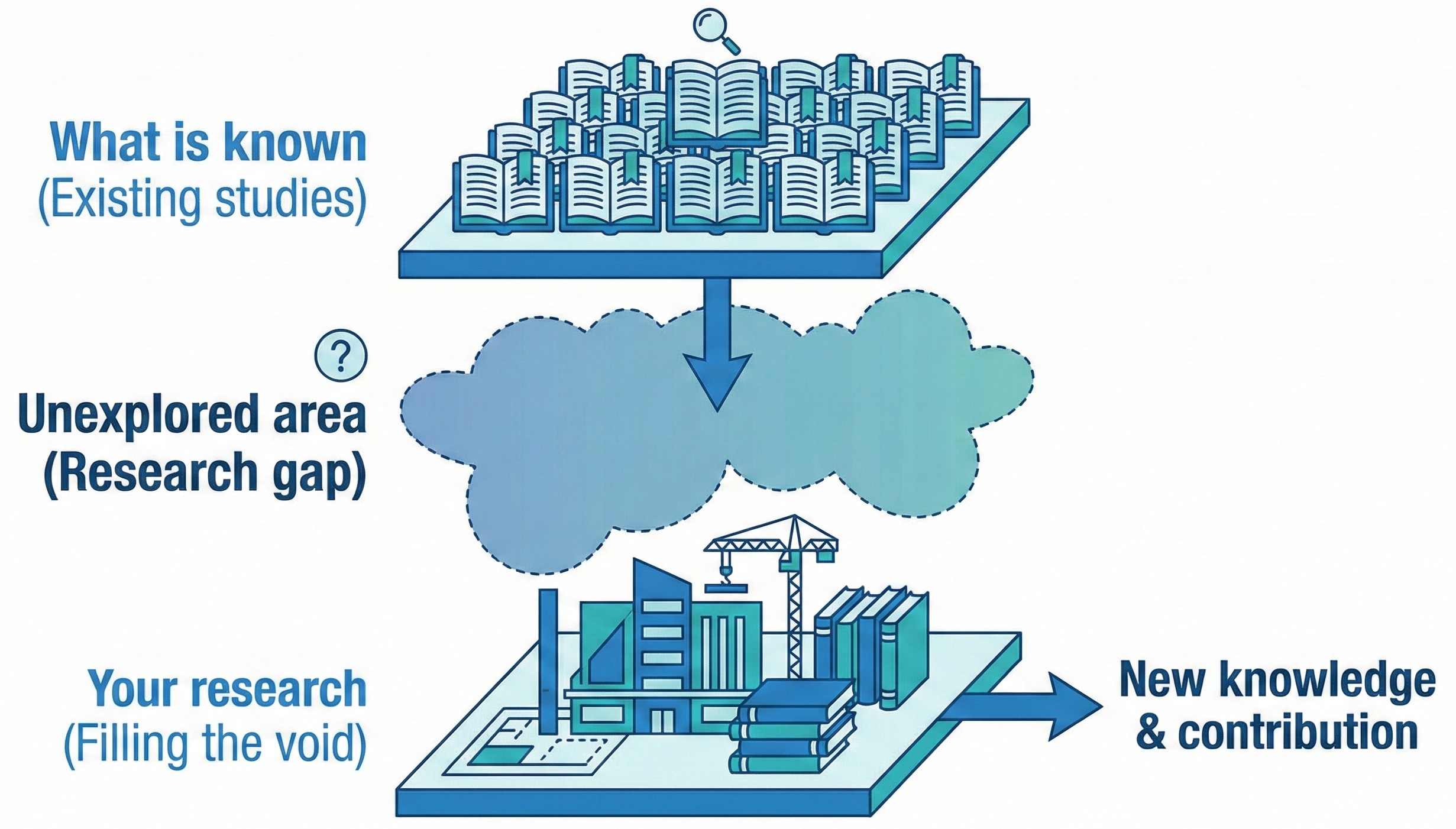
Visualizing the research gap: positioning your study between what is already known and what architectural practice still needs to understand.

For architectural research specifically, gap identification must consider the unique nature of design-led inquiry [10]. Traditional systematic review methods developed for medical or social sciences may need adaptation to accommodate the iterative, reflexive nature of design research [10]. A study examining research methodologies in architecture found that effective gap identification requires “hybrid methods” that combine traditional literature analysis with critical examination of built precedents, emerging technologies, and evolving cultural contexts [10]. The goal is not simply to find what hasn’t been studied, but to identify what needs to be studied to advance both theoretical understanding and practical application [6].

Articulating the Problem Statement: Precision as Power

The problem statement is the intellectual core of your proposal – the sentence or brief paragraph that captures the essence of your research challenge with absolute clarity [11]. In architectural research, crafting an effective problem statement requires balancing specificity with relevance, ensuring your question is neither so narrow that it lacks broader significance nor so broad that it becomes unmanageable [11].

An effective problem statement contains several essential elements: it identifies the specific phenomenon or issue to be investigated, it contextualizes this problem within existing knowledge (what we already know), it articulates precisely what remains unknown (what we need to know), and it demonstrates why this knowledge gap matters (why we need to know it) [11]. For design-based architectural research, the problem statement must also indicate how design inquiry will serve as a method of knowledge creation, not merely as the end product [10].

Consider the difference between a weak and strong problem statement in architectural research. A weak statement might read: “This research will explore sustainable design in tropical architecture.” This lacks specificity, fails to identify a clear gap, and provides no indication of methodology or significance [11]. A strong statement would be: “Despite growing evidence that computational optimization of building envelopes can reduce cooling energy by 20-30% in tropical climates, the integration of parametric design tools into the design curriculum of Southeast Asian architecture programs remains limited, with 89% of practitioners reporting inadequate training in these methods. This research investigates how visual programming platforms can be strategically integrated into design studio pedagogy to enhance students’ capacity for climate-responsive design thinking.” This statement identifies a specific problem (gap in computational design education), contextualizes it with evidence, and indicates both methodology (pedagogical intervention) and significance (enhanced climate-responsive design capacity) [11].

The problem statement must be inherently “problematic” – it must identify a genuine tension, contradiction, or gap that demands resolution [7]. In architectural research, this often emerges from the disconnect between theoretical ideals and practical realities, between global trends and local contexts, or between established methods and emerging challenges [2].

Core structure of an architectural research proposal: from background and problem statement to framework, methods, and timeline.

Building the Conceptual Framework: The Intellectual Scaffold

If the problem statement is the core of your proposal, the conceptual framework is the intellectual scaffold that supports your entire investigation [12]. A conceptual framework in architectural research is “a network of interlinked concepts that together provide a comprehensive understanding of a phenomenon,” serving as both a lens through which you view your research problem and a structure that organizes your inquiry [12].

The development of a conceptual framework follows a systematic process [13]. First, you must identify your overarching research question and study parameters – the boundaries that define what is and isn’t included in your investigation [12]. Second, you extract key concepts and variables from your literature review, identifying the fundamental ideas that will structure your analysis [12]. Third, you map the relationships between these concepts, creating a visual or verbal representation of how they interact to produce the phenomenon you’re studying [12].

For architectural research, conceptual frameworks often draw from multiple disciplinary sources – architectural theory, environmental science, social theory, computational logic, or material science – creating what scholars call an “interdisciplinary positioning” [13]. This multidisciplinary integration is not merely additive but synthetic, creating new theoretical constructs that can address the complexity of architectural problems [13].

A particularly powerful framework structure in design research is the “input-throughput-output” model, which maps how raw data and observations (inputs) are processed through analytical and synthetic methods (throughput) to generate design solutions or theoretical insights (outputs) [12]. This model makes the research process transparent and replicable, addressing a common criticism of design research as being overly subjective or opaque [10].

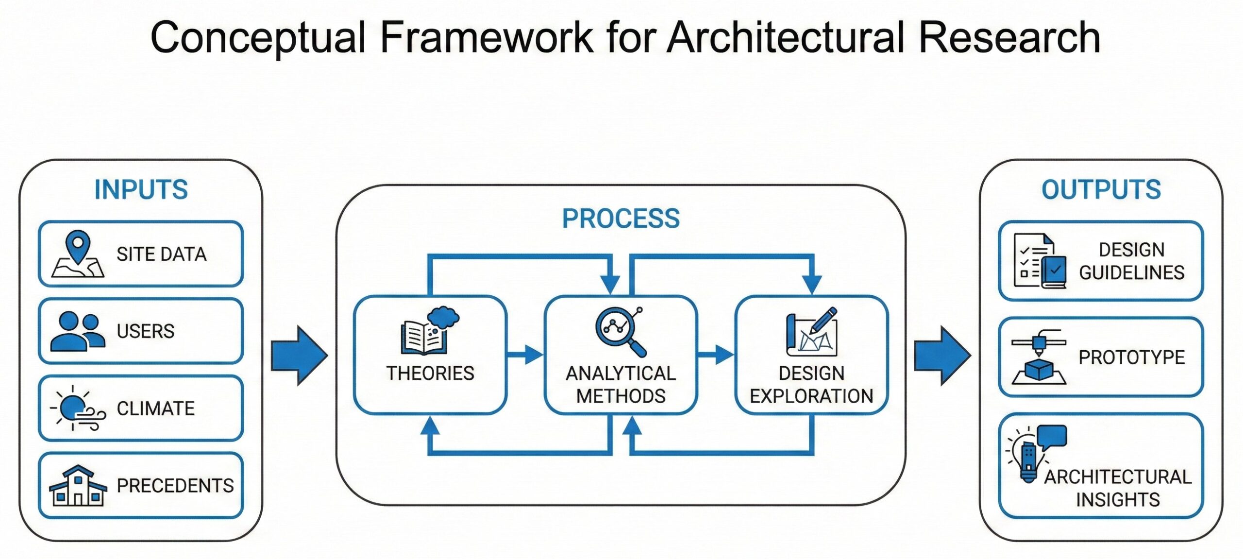
A conceptual framework in architecture links inputs, processes, and outputs into a coherent system of ideas that guides both analysis and design decisions.

The conceptual framework should be presented both verbally and visually [12]. The verbal articulation explains the theoretical underpinnings and relationships in detail, while the visual representation – often a diagram or flowchart – provides an at-a-glance understanding of your research logic [12]. In architectural research, where visual thinking is fundamental to the discipline, the quality of your framework diagram often serves as a proxy for the clarity of your thinking [2].

Navigating Methodological Complexity: Design as Research, Research as Design

Methodology remains the most misunderstood section of architectural research proposals, often confused with methods, approaches, or data collection techniques [4]. To clarify: methodology refers to your overall research strategy and philosophical stance – the “why” behind your choices – while methods are the specific techniques and tools you will use – the “how” of your investigation [4].

Research through design as an iterative cycle: framing problems, experimenting through design, evaluating, and feeding insights back into theory.

In architectural research, methodological complexity arises from the discipline’s dual nature as both a creative practice and an academic field [10]. Traditional research paradigms – quantitative, qualitative, and mixed-methods – must be adapted to accommodate design-led inquiry, where the act of designing itself serves as a mode of knowledge creation [14]. This has led to the emergence of specific methodological frameworks for architectural research, including “research through design,” “research for design,” and “research about design” [14].

Research Through Design: When Making is Knowing

Research through design positions the design process itself as the primary method of investigation, where iterative design experimentation generates new knowledge about materials, forms, or spatial relationships [14]. This approach, widely adopted in design-led PhD programs at institutions like MIT and the Royal Danish Academy, treats each design iteration as a “probe” that tests hypotheses and reveals unexpected insights [13].

Implementing research through design in your proposal requires articulating how design decisions will be systematically documented, analyzed, and reflected upon [14]. You must establish criteria for evaluating design outcomes that go beyond subjective aesthetic judgment to include measurable performance metrics, user experience data, or theoretical consistency [14]. A study of design-led research methods emphasizes the importance of “systematic quality criteria” including regularity (consistent application of methods), relevance (clear connection to research questions), and universality (applicability beyond the specific case) [15].

Qualitative Methods in Architectural Research: Beyond Observation

Qualitative research methods – including interviews, ethnography, case studies, and document analysis – are particularly valuable in architectural research for understanding how spaces are experienced, how design processes unfold, and how cultural contexts shape built form [16]. However, architectural applications of qualitative methods require discipline-specific adaptations [16].

The “six tactics” framework developed for architectural fieldwork in vernacular contexts provides a practical model: documentation through photography and sketching, physical surveys using anthropometric measurement, in-depth interviews with open-ended questions, interactive discussions with community stakeholders, participatory observation where the researcher engages directly with spatial use, and architectural interpretation that synthesizes findings into design-relevant insights [17]. These tactics are “initiated inductively, formulated contextually with ethics and aesthetics, and communicated with simple language” [17].

Mapping research methods in architecture: qualitative, quantitative, and mixed approaches overlap to address complex spatial questions.

Bridging the Gap: Mixed Methods and Hybrid Approaches

Given the complexity of architectural problems, mixed-methods approaches that combine quantitative performance analysis with qualitative spatial experience research often provide the most comprehensive understanding [18]. Computational simulations can quantify energy performance, daylighting, or structural efficiency, while interviews and observations reveal how users actually interact with and perceive these spaces [16].

A recent methodological review of architectural research proposes “hybrid methods” that simultaneously apply different modes of inquiry based on the specific demands of each research phase [10]. For example, early exploratory phases might emphasize qualitative case studies and interviews to understand the problem deeply, middle phases might employ quantitative parametric studies to test design variables, and later phases might return to qualitative methods to evaluate the experiential quality of design outcomes [10].

Your proposal must clearly articulate not only which methods you will use but why these specific methods are appropriate for your research questions and how they will be integrated to produce coherent findings [4].

Literature Review as Intellectual Cartography: Mapping the Territory

The literature review section of your proposal is not a comprehensive summary of everything ever written on your topic; rather, it is a strategic mapping of the intellectual territory that contextualizes your specific contribution [19]. This distinction is critical: a literature review should be selective, critical, and above all, argumentative – it should build a case for why your research is necessary [19].

A systematic approach to literature review follows structured protocols that make your search strategy transparent and replicable [20]. Begin by formulating clear search queries using the “building blocks” method, where each key concept in your research question becomes a separate search term [20]. For example, if investigating computational design methods for bamboo structures, your building blocks might be: (1) “computational design” OR “parametric design” OR “algorithmic design,” (2) “bamboo” OR “natural materials,” and (3) “structural optimization” OR “form-finding” [20].

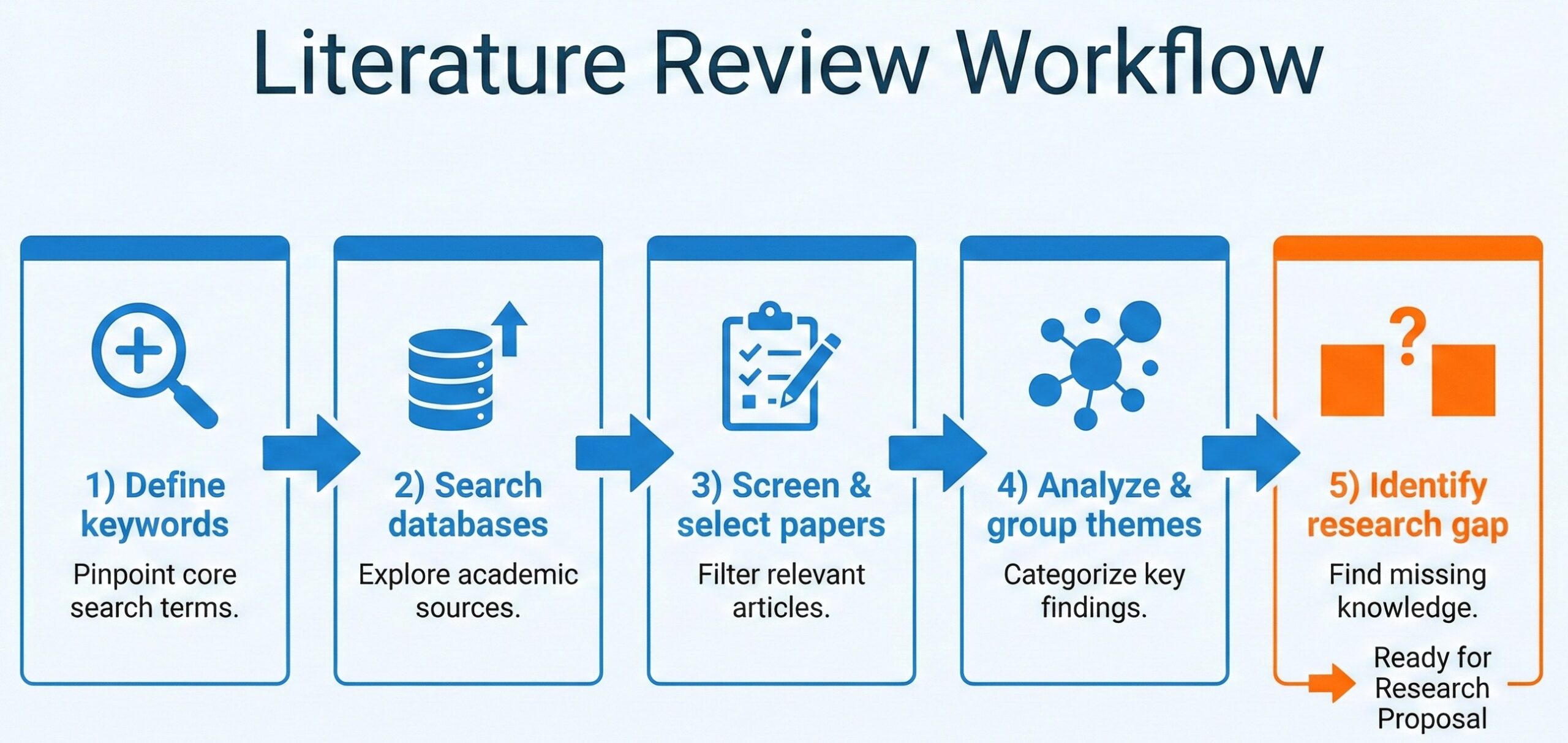
From keywords to gaps: a step‑by‑step workflow for turning a literature review into a clear argument for your architectural research.

Document your search process meticulously, recording which databases you searched, what search strings you used, how many results each query generated, and what date you conducted the search [21]. This documentation serves two purposes: it demonstrates the rigor of your review process, and it allows you to update your search later when revising or expanding your research [21].

The analysis phase of your literature review should organize findings thematically or chronologically, identifying patterns, contradictions, and gaps [19]. For architectural research, consider organizing your review around key debates in the field (e.g., the tension between vernacular authenticity and contemporary innovation), methodological approaches (e.g., different techniques for assessing thermal comfort), or case study typologies (e.g., comparative analysis of tropical climate design strategies) [6].

Critically, your literature review must culminate in a clear articulation of the research gap that your study will address [8]. This is where you explicitly state: “Previous research has examined X and Y, but has not adequately addressed Z, which is significant because…” [8]. This gap statement serves as the bridge between existing knowledge and your proposed contribution [8].

Defining Scope and Limitations: The Boundaries of Rigor

A common mistake in research proposals is attempting to address too broad a scope, leading to superficial treatment of complex issues [22]. Paradoxically, narrowing your scope actually strengthens your proposal by demonstrating focused expertise and feasible methodology [22].

The scope section should clearly define what is included in your study: Which geographic context? Which building typology? Which user population? Which time period? [22] These boundaries should be justified based on practical feasibility (access to data, timeline constraints) and conceptual coherence (what constitutes a meaningful unit of analysis) [22].

Scope defines the focus of your study; limitations mark what stays outside—both are essential for a rigorous and feasible thesis.

Equally important is acknowledging limitations – factors outside your control that may affect your research [22]. For architectural research, common limitations include restricted site access, limited availability of historical documentation, software or computational constraints, or weather-dependent data collection [22]. Acknowledging these limitations demonstrates sophisticated understanding of research challenges and preempts potential criticisms [22].

However, limitations should never be used as excuses for methodological weaknesses [22]. If a limitation genuinely threatens the validity of your findings, you must either redesign your methodology to address it or reconsider whether your research question is feasible [4].

The Strategic Research Roadmap: Timeline and Feasibility

A credible research proposal must include a realistic timeline that demonstrates you understand the scope of work required and have planned appropriately [4]. For architectural thesis projects, this typically spans 6-12 months from proposal approval to final submission [23].

Break your timeline into distinct phases: literature review and theoretical framework development (typically 1-2 months), case study selection and preliminary analysis (1-2 months), primary data collection (2-4 months, depending on methodology), design development or analytical synthesis (2-3 months), and writing and documentation (ongoing throughout, with intensive final phase of 1-2 months) [23].

Build buffer time into your schedule for inevitable delays: site access complications, weather disruptions for fieldwork, longer-than-expected software learning curves, or multiple design iteration cycles [23]. Research methodology guides consistently emphasize that “feasibility is more important than ambition” – a completed study on a focused question is infinitely more valuable than an abandoned study on a grandiose question [1].

From Proposal to Practice: Ensuring Continuity

The greatest risk in architectural research is discontinuity between what is proposed and what is actually executed [24]. To mitigate this risk, treat your proposal not as a static document to be filed away after approval, but as a living framework that guides your ongoing work [24].

Several strategies support continuity [24]. First, extract your key research questions and pin them in your workspace – these should drive every decision throughout your research process [24]. Second, maintain a research journal documenting how your understanding evolves as you collect data and develop designs, noting any necessary adaptations to your original methodology [24]. Third, schedule regular check-ins with advisors to ensure you remain aligned with your proposal’s core commitments while allowing for emergent insights [24].

Recognize that some deviation from your proposal is not only acceptable but expected in design research, where iterative experimentation often reveals unexpected paths [25]. The key is documenting these changes and justifying them based on evidence or theoretical reasoning, maintaining the intellectual rigor that your proposal established [24].

Conclusion: Research as Architectural Practice

The process of writing a research proposal is itself a form of architectural practice – you are designing the structure of an investigation, creating a framework that is both rigorous and flexible, that provides clear guidance while allowing for creative exploration [26]. The skills developed through this process – systematic analysis, critical thinking, clear argumentation, methodological rigor – are precisely the skills that distinguish excellent architects from merely competent ones [26].

In an era where architectural practice increasingly demands evidence-based design, computational literacy, and interdisciplinary collaboration, the capacity to formulate and execute rigorous research is no longer optional but essential [3]. The research proposal is where this capacity is first tested and developed [1].

As you embark on your proposal writing journey, remember that the goal is not perfection but clarity, not comprehensiveness but focus, not imitation but originality [27]. Your proposal should reflect your authentic intellectual curiosity channeled through systematic methodology – it should be recognizably yours while meeting the universal standards of scholarly rigor [27].

The blank page that once seemed impossibly intimidating becomes, through strategic effort and systematic thinking, a blueprint for meaningful contribution to architectural knowledge [28]. This transformation – from uncertainty to structure, from question to methodology, from idea to investigation – is the essential first step in the journey from student to scholar, from designer to design researcher [28].

References

[1] L. Groat and D. Wang, Architectural Research Methods, 2nd ed. Hoboken, NJ: John Wiley & Sons, 2013.

[2] K. Sailer and A. Penn, “Bridging the gap between architectural research and design practice,” in Proceedings of the 6th International Space Syntax Symposium, Istanbul, Turkey, 2007, pp. 1–12.

[3] “New RAND study highlights gaps between architecture academia and practice,” American Institute of Architects, Mar. 4, 2025. [Online]. Available: https://www.aia.org/about-aia/press/new-rand-study-highlights-gaps-between-architecture-academia-and-practice

[4] J. W. Creswell and J. D. Creswell, Research Design: Qualitative, Quantitative, and Mixed Methods Approaches, 5th ed. Thousand Oaks, CA: SAGE Publications, 2018.

[5] “How to write a problem statement,” Scribbr, Nov. 19, 2023. [Online]. Available: https://www.scribbr.com/research-process/problem-statement/

[6] E. J. Park, “The impact of research and representation of site analysis on landscape architectural design,” Landscape Research, vol. 48, no. 3, pp. 420–435, 2023.

[7] D. A. Schön, The Reflective Practitioner: How Professionals Think in Action. New York: Basic Books, 1983.

[8] “How to find research gaps: Complete analysis guide,” Fynman, Jun. 29, 2025. [Online]. Available: https://fynman.com/resources/research-gap-analysis/

[9] M. Elf et al., “A systematic review of research gaps in the built environment of inpatient healthcare settings,” HERD: Health Environments Research & Design Journal, vol. 17, no. 3, pp. 47–68, 2024.

[10] M. Munarim and J. Duarte, “Architectural research in hybrid mode: Combining diverse methods within design-based architectural research inquiry,” Architectural Research Quarterly, vol. 27, no. 1, pp. 62–78, 2023.

[11] “How to write a research problem statement,” Enago Academy, Jul. 12, 2023. [Online]. Available: https://www.enago.com/academy/research-problem-statement/

[12] “What is a conceptual framework and how to make it,” Researcher.Life, Aug. 24, 2025. [Online]. Available: https://researcher.life/blog/article/what-is-a-conceptual-framework-and-how-to-make-it-with-examples/

[13] K. Honour et al., “Building the conceptual framework for a design-led PhD,” CUBIC Journal, vol. 7, no. 1, pp. 78–95, Dec. 2024.

[14] C. Frayling, “Research in art and design,” Royal College of Art Research Papers, vol. 1, no. 1, pp. 1–5, 1993.

[15] A. Lucas, “Research through design under systematic quality criteria: Methodology and teaching research,” in Research Culture in Architecture: Cross-Disciplinary Collaboration, M. Düchs et al., Eds. Basel: Birkhäuser, 2021, pp. 103–118.

[16] J. W. Creswell and V. L. Plano Clark, Designing and Conducting Mixed Methods Research, 3rd ed. Thousand Oaks, CA: SAGE Publications, 2018.

[17] M. Edepea and M. B. Susetyarto, “The six tactics in architectural qualitative research at Nua Bena, Flores,” International Journal of Scientific & Technology Research, vol. 9, no. 3, pp. 1695–1700, Mar. 2020.

[18] R. K. Yin, Case Study Research: Design and Methods, 6th ed. Thousand Oaks, CA: SAGE Publications, 2018.

[19] H. M. Cooper, Synthesizing Research: A Guide for Literature Reviews, 3rd ed. Thousand Oaks, CA: SAGE Publications, 1998.

[20] B. Kitchenham and S. Charters, “Guidelines for performing systematic literature reviews in software engineering,” Technical Report EBSE-2007-01, Keele University, 2007.

[21] D. Moher et al., “Preferred reporting items for systematic reviews and meta-analyses: The PRISMA statement,” PLoS Medicine, vol. 6, no. 7, e1000097, 2009.

[22] M. Q. Patton, Qualitative Research & Evaluation Methods, 4th ed. Thousand Oaks, CA: SAGE Publications, 2015.

[23] University of Waterloo Library, “Thesis research in architecture: Research methods,” Apr. 30, 2020. [Online]. Available: https://subjectguides.uwaterloo.ca/architecturethesis/methods

[24] J. A. Maxwell, Qualitative Research Design: An Interactive Approach, 3rd ed. Thousand Oaks, CA: SAGE Publications, 2013.

[25] K. Charmaz, Constructing Grounded Theory, 2nd ed. London: SAGE Publications, 2014.

[26] B. Lawson, How Designers Think: The Design Process Demystified, 4th ed. Oxford: Architectural Press, 2006.

[27] H. Rittel and M. Webber, “Dilemmas in a general theory of planning,” Policy Sciences, vol. 4, no. 2, pp. 155–169, 1973.

[28] T. Brown, Change by Design: How Design Thinking Transforms Organizations and Inspires Innovation. New York: HarperBusiness, 2009.

The Computational Divide: Indonesia’s BIM Adoption Gap and What It Means for Our Future

The global architecture, engineering, and construction (AEC) industry stands at a technological inflection point. Building Information Modeling – the digital representation of physical and functional characteristics of facilities – has transitioned from experimental methodology to industry standard in developed markets [1]. Singapore mandates BIM for all public projects exceeding 5,000 m² since 2015 [1], and the United Kingdom requires Level 2 BIM on government-funded projects since 2016 [2]. These mandates correlate with measurable productivity gains: studies document 15-20% reductions in project delivery time and 10-15% cost savings through clash detection and coordination improvements [3].

For a nation like Indonesia, standing at the crossroads of immense development and profound infrastructure challenges, the question is no longer if this paradigm will arrive, but whether our industry will shape its adoption or simply consume foreign expertise in the process [4]. To ignore this transformation is to risk being relegated to a consumer of digital tools rather than a leader in construction innovation. This is not merely about learning new software; it is about fundamentally rethinking the process of building design and delivery to address the unique complexities of our tropical context and the scale of development our nation requires [5].

Yet here lies the uncomfortable truth that nobody in power wants to discuss: Indonesia has the regulatory framework in place [6], but we lack the infrastructure to make it actually work [7].

Before we go further, let me be direct about something. You have probably heard that Indonesia has no BIM mandate [8], that our construction industry operates in a regulatory vacuum compared to Singapore or Malaysia [9]. That narrative is flatly incorrect. It persists because the people who should be communicating these policies are not, and because implementation failure looks so similar to policy absence that the distinction has become invisible.

Indonesia established clear BIM mandates years ago. Peraturan Menteri PUPR No. 22/PRT/M/2018, issued on September 14, 2018, explicitly requires Building Information Modeling for state building projects exceeding 2,000 m² floor area and more than two floors [6]. The regulation identifies BIM as the methodology for supporting planning and supervision effectiveness, emphasizing cross-disciplinary collaboration and data integration from project inception [10]. This applies to all non-simple state building construction, which in a country the size of Indonesia represents thousands of projects annually [5].

But that is only part of the picture. In August 2021, the Directorate General of Highways issued Surat Edaran Dirjen Bina Marga No. 11/SE/Db/2021 mandating BIM for roads, highways, toll roads, bridges, overpasses, viaducts, tunnels, and underpasses, including all complementary structures [11]. This directive provides detailed implementation guidelines covering organizational structure, budget allocation, minimum information requirements per project phase, and monitoring protocols [11]. The government has also implemented Peraturan Pemerintah No. 16/2021, which modernized building approval processes and established technical standard compliance frameworks that implicitly support BIM through digital documentation requirements [12].

So Indonesia has three major regulatory instruments requiring BIM implementation. The question, then, is not why we lack regulation. The question is why only 5% of professionals are formally trained in BIM [8], why 70% of people know what BIM is yet only 38% actually use it[8], and why the infrastructure to support these mandates remains fragmented rather than coordinated [7].

That is the real problem. And it is far more solvable than regulatory absence would be, because it means we have already made the policy decision. We just have not followed through on building the ecosystem to make policy meaningful.

Let me present a statistic that should trouble everyone in the construction industry: 70% of Indonesian construction professionals report awareness of BIM, yet only 38% actually implement it in their projects [8]. That is a 32-percentage-point gap between knowing something matters and actually doing it. This is not a knowledge problem. This is a structural problem [7].

In Malaysia, by contrast, the trajectory tells a different story [9]. In 2016, Malaysia had 17% adoption [13]. By 2019, after coordinated government intervention, that climbed to 49%—a 188% increase in just three years [14]. By 2021, Malaysia reached 55% adoption [15]. Malaysia did not accomplish this by issuing mandates and waiting. Malaysia did it through simultaneous intervention in three domains: training infrastructure, software accessibility, and regulatory enforcement [9]. They built the ladder before telling people to climb.

Indonesia issued its first mandate in 2018, nearly as early as Malaysia’s full policy commitment. Yet in 2021, when Malaysia reached 55% adoption, Indonesia remained at 38% [8]. We had the regulation earlier. We have fewer practitioners trained [7]. The gap reveals not a failure of policy but a failure of implementation – the decision to mandate was followed by insufficient investment in the conditions that make mandates meaningful [7].

When you mandate BIM but only 5% of your workforce has formal training [8], you are not accelerating adoption. You are creating frustration. You are forcing firms to hire foreign consultants or purchase expensive external expertise. You are, in effect, outsourcing your capability development to neighboring countries and international firms. This is exactly what we are doing right now.

The Cost Barrier: The Wall We Forgot to Acknowledge

Here is what the government regulation does not address, and what nobody in policy circles seems willing to confront: BIM software is economically prohibitive for most Indonesian practitioners [7], especially entry-level professionals and small-to-medium enterprises that comprise 95% of our construction sector [16].

Autodesk Revit, the industry standard architectural BIM platform, costs approximately $2,500 annually [17]. AutoCAD adds another $500. The full AEC Collection runs to $3,500 per year. For an entry-level architect or engineer earning approximately Rp 42-50 million annually (roughly $2,850-3,400) [18], this represents 70-90% of their annual salary. For the complete collection, we are talking about costs that exceed 100% of an entry salary [7]. Full ArchiCAD sits at roughly $2,200 – still 65-80% of entry salary. Even the “affordable” options like SketchUp Pro with extensions hit $1,200, or 35-42% of salary [17].

Now compare this to what other countries have done. Malaysia’s government implemented subsidies reducing effective software costs to 37-46% of entry salary [19]. Singapore’s BIM Fund covered up to 80% of software costs during the capacity-building phase in the early 2010s [1]. Indonesia has no systematic subsidy program. None. Zero. We have mandates with cost barriers that make compliance economically unreasonable for the professionals required to implement them.

This is not a hypothetical problem. This explains the awareness-implementation gap. Professionals understand BIM matters. They know it is coming. They simply cannot afford to invest in capabilities that their employers have not decided to fund. And employers – especially the SMEs that form the backbone of Indonesian construction – cannot justify $2,500-3,500 per seat when they operate on thin margins and see no enforcement incentive [16].

The cost problem compounds when you consider training. Comprehensive BIM competency requires approximately 180-260 hours of structured learning: 80-120 hours for software training, 40-60 hours for BIM management fundamentals, and 60-80 hours for discipline-specific workflows [20]. In Indonesia, this totals roughly Rp 21-37 million ($1,415-2,495) in direct training costs [7], representing 50-88% of an annual entry-level salary [18]. Malaysia’s subsidized training through CIDB reduces practitioner out-of-pocket costs to 20-30% of market rates [19]. Indonesia offers no equivalent.

When you combine the software barrier ($2,500-3,500) with the training barrier ($1,415-2,495), you are asking individuals to invest $4,000-6,000 from personal resources in a capability that their employers have not yet fully committed to purchasing. This is not a policy failure. This is an economic wall masquerading as a regulatory gap.

Why the Infrastructure Matters More Than the Mandate

Singapore’s BIM success is often attributed to their mandate, but that misses the real story [1]. Singapore’s 2015 mandate worked because it arrived after a decade of preparation. In 2010, the Building and Construction Authority established a BIM steering committee. In 2012, Singapore launched the BIM Fund  – a direct subsidy program supporting training and software adoption [1]. Only after this capacity-building phase was the mandate introduced in 2015, initially for projects exceeding $20,000 m², then gradually reduced to $5,000 m² [1]. This phased approach, combined with financial support and technical standards development, produced the 80%+ adoption rates Singapore achieved by 2020 [1].

Malaysia followed a parallel path [9]. National BIM Guidelines (NBIMS-MY) were established in 2015 [21]. The Construction Industry Transformation Programme (CITP) ran from 2016-2020 [14], explicitly focusing on training infrastructure development [19]. Only after this preparation phase did Malaysia announce its mandate for 2025 enforcement [15]. This sequencing was not accidental. It was deliberate policy design: build capacity first, enforce compliance second. This avoided the shock of mandatory adoption without practitioner readiness [9].

Indonesia reversed this sequence [22]. We issued the mandate in 2018 without first building the supporting infrastructure. The regulation exists, but the training ecosystem is fragmented, software costs remain prohibitive without subsidies, and enforcement mechanisms lack clarity [6][7]. We told people to climb a ladder before we finished constructing it.

The evidence of this implementation gap is stark in the statistics. Only 23% of Indonesian universities include BIM in core curriculum [23]. Sixty-two percent offer it as optional elective only. Fifteen percent provide no BIM exposure whatsoever [23]. Compare this to Malaysia’s National Higher Education Blueprint 2015-2025, which mandates BIM competency across all construction-related degree programs [21]. Indonesia has no equivalent requirement. We have no unified BIM certification framework comparable to Malaysia’s MyBIM certification or Singapore’s BCA Academy credentials [1][19]. We have fragmented private training providers with inconsistent quality standards and limited incentive for practitioners to invest in credentials when employers do not recognize their value [7].

This fragmentation produces the 5% formally trained problem [8]. In a survey of 40 Indonesian construction professionals, only 2 reported receiving formal BIM training [8]. Five percent. In a country with a construction sector exceeding $30 billion annually [16], we have trained fewer than 5% of practitioners in the methodology we mandated [8]. This is not a policy failure. This is the result of mandating without simultaneously investing in the conditions that make mandates effective.


📊 Lihat Infografis Interaktif Lengkap

The Regional Context: What We Are Competing Against

Malaysia’s adoption trajectory is particularly important because it represents our closest competitor [24]. Malaysia is not ahead of Indonesia by accident or unique advantage. Malaysia is ahead because they made deliberate policy choices about sequencing: capacity building before enforcement [9], support systems alongside mandates [19], clear standards developed before compliance requirements [21].

By 2021, when Indonesia maintained 38% adoption, Malaysia had reached 55% [15]. The gap has continued to widen. Malaysia’s 2025 enforcement deadline will likely accelerate adoption further [15], while Indonesia’s ambiguous implementation timeline creates uncertainty about when compliance will be genuinely required. Firms planning long-term capability investment face a choice: invest now with unclear enforcement pressure, or wait and see. Waiting becomes the rational decision, which means adoption remains optional and voluntary rather than strategic and competitive [22].

Thailand and the Philippines offer cautionary tales in the opposite direction [25]. Thailand maintains approximately 30% adoption driven primarily by voluntary adoption for multinational projects [25]. The Philippines sits at roughly 20%, with adoption concentrated in firms serving foreign clients [25]. Neither country established government mandates. Neither built comprehensive support systems. The result is adoption that remains shallow, concentrated in elite firms, and disconnected from mainstream practice [25].

For Indonesia, the choice is becoming clearer. We can either build the supporting infrastructure that makes our mandates meaningful, or we can watch our regional neighbors advance while we maintain the appearance of policy without the substance of practice. The mandate exists. What is missing is the ecosystem to make it real.

The University Problem: Where It Should Start

One of the most fixable problems is also one of the most neglected: higher education [26]. Universities are where professionals acquire foundational competencies and where industry expectations become normative. If you graduate from a degree program without BIM exposure, you enter practice with a gap that expensive remedial training must later fill [20].

Only one in four Indonesian architecture and civil engineering programs include BIM in required coursework [23]. The rest treat it as optional or ignore it entirely. This is not because the faculty lack knowledge. It is because accreditation standards do not require it, because integrating BIM into curriculum requires faculty development that universities have not budgeted for, and because there is no enforced industry expectation creating demand for BIM-competent graduates [26].

Malaysia’s approach is different [21]. Their accreditation framework explicitly requires BIM competency. The result is that all graduates enter practice with baseline literacy. They may not be experts, but they are not starting from zero. This creates a virtuous cycle: employers can assume entry-level competency, so they invest in advanced training rather than foundational training [19]. Practitioners can market themselves on the basis of standard competency rather than specialized expertise [9].

Indonesia could implement this same mechanism immediately [26]. The architecture accreditation board (BAN-PT) could mandate that BIM represents a minimum 6 credit hours of study in all architecture degree programs by 2028. Civil engineering and construction management programs could receive the same requirement. This single policy change would transform the supply side of the training problem [23]. Every architect and engineer graduating in the 2030s would arrive in practice with BIM literacy, making adoption far less economically burdensome [26].

This costs the government nothing. It requires no budget allocation. It simply requires a decision that BIM competency is non-negotiable in construction-related degree programs. Yet it remains undone, which tells you something important about the gap between policy rhetoric and policy implementation in Indonesian infrastructure transformation [22].

What Actually Needs to Happen

Let us be clear about what solving this problem requires. It is not more regulation. We have enough regulation [6]. It is not more speeches about digital transformation. We have heard plenty of speeches. What is required is coordinated infrastructure investment in four specific domains [27].

First, we need an enforcement mechanism for existing mandates [28]. The Permen PUPR 22/2018 and SE Dirjen Bina Marga 11/2021 exist, but they lack teeth [6][11]. Unlike Singapore’s Building and Construction Authority, which audits BIM model submissions and rejects non-compliant applications [1], Indonesia lacks systematic verification [12]. Make compliance audits part of the building approval process. Require BIM model submission for projects covered by the mandate. Establish consequences for non-compliance – not punitive measures that cripple projects, but enforcement that makes the mandate real rather than rhetorical [28].

Second, we need to acknowledge and address the cost barrier through direct subsidy [27]. Launch an Indonesian BIM Fund modeled on Singapore’s and Malaysia’s success [1][19]: allocate Rp 50-75 billion annually ($3.4-5 million) to subsidize 70% of training and software costs for practitioners and SMEs [27]. Target 5,000-7,000 professionals annually for training support. This is not expensive by infrastructure standards. It is less than the cost overrun on a single major highway project. Yet it could transform adoption within three years [27].

Third, integrate BIM competency requirements into accreditation standards immediately [26]. Require all architecture, civil engineering, and construction management programs to include a minimum BIM module in core curriculum by 2028 [23]. Provide faculty development support to make implementation feasible [26]. This single policy transforms the supply side of the training problem at minimal cost [26].

Fourth, establish a unified BIM certification and standards framework [29]. Create Indonesia BIM Standards (IBIMS) adapted from existing frameworks but specific to our regulatory and technical context [6]. Develop a nationally recognized certification pathway – Level 1 fundamentals, Level 2 discipline-specific workflows, Level 3 BIM management [29]. Create institutional recognition for certification so employers understand the credential’s meaning [29]. This requires coordination among professional organization (IAI) and government agencies, but it can be accomplished within 18 months [29].

These are not dramatic changes. They are not revolutionary. They simply represent the implementation infrastructure that every country that successfully accelerated BIM adoption built before or simultaneously with their mandates [1][9][21]. Singapore did this in the 2010s [1]. Malaysia did this in 2015-2020 [9]. Indonesia is doing this in fragments without coordination, which means we are doing it inadequately [22].

The larger strategic question is whether Indonesia will become a producer or consumer of construction innovation [5]. If we build this infrastructure, we create a domestic industry capability that generates intellectual property, professional prestige, and competitive advantage [5]. We position Indonesian firms to lead regional projects rather than follow foreign expertise. We create economic value that stays in our country rather than flowing to international consultants [30].

If we do not, we have mandates without capability, policy without practice, and the appearance of transformation without its substance. We become the market for foreign BIM services rather than the provider [22].

The real barrier to implementation is not technical complexity or cost – both are eminently manageable. The barrier is political will [22]. It is easier to issue a regulation than to build the infrastructure supporting it. It is easier to talk about digital transformation than to fund it. It is easier to blame industry resistance than to acknowledge that industry is responding rationally to mandates without supporting systems [28].

This requires sustained bureaucratic commitment, cross-agency coordination, and budget allocation competing with other priorities. It requires technocrats at Ministry of Public Works, Ministry of Education, professional organizations, and industry associations to align on a common approach and maintain focus for 3-5 years. This is not impossible [1][9]. Singapore, Malaysia, and dozens of other countries have demonstrated it is possible. But it requires intentional, sustained, politically supported effort [27].

Indonesia’s construction sector is one of the largest in Southeast Asia [16]. The infrastructure development requirements are immense – urban transportation, affordable housing, climate adaptation, disaster resilience [5]. BIM is not a luxury amenity [5]. It is a competitive necessity for managing the complexity and scale of development a developing nation with Indonesia’s geography and population requires [5]. Every year we defer building this capability, we increase the gap between what we are capable of and what we need to accomplish [24].

The mandate is there. It has been there since 2018 [6]. What is missing is the decision to make it real [22].

References

[1] Building & Construction Authority Singapore, “Singapore BIM Roadmap Report 2015-2020,” BCA Singapore, 2020. [Online]. Available: https://www.bca.gov.sg/bim

[2] UK Government, “Government Construction Strategy 2016-2020,” Infrastructure and Projects Authority, 2016. [Online]. Available: https://www.gov.uk/government/publications/government-construction-strategy-2016-2020

[3] McKinsey Global Institute, “Reinventing Construction: A Route to Higher Productivity,” 2017. [Online]. Available: https://www.mckinsey.com/business-functions/operations/our-insights/reinventing-construction-through-a-productivity-revolution

[4] World Economic Forum, “The Global Competitiveness Report 2020: How Countries Are Performing on the Road to Recovery,” 2020. [Online]. Available: https://www.weforum.org/reports/the-global-competitiveness-report-2020

[5] Sustainable Development Goals Report 2023, United Nations, 2023. [Online]. Available: https://unstats.un.org/sdgs/report/2023/

[6] Kementerian Pekerjaan Umum dan Perumahan Rakyat, “Peraturan Menteri PUPR Nomor 22/PRT/M/2018 tentang Pembangunan Bangunan Gedung Negara,” 2018. [Online]. Available: https://peraturan.bpk.go.id/Details/159730/permen-pupr-no-22prtm2018-tahun-2018

[7] SMERU Research Institute, “Digital Skills Diagnostic: Indonesia’s Construction Sector,” 2023. [Online]. Available: https://smeru.or.id/en/publication/digital-skills-diagnostic-construction

[8] A. Firmansyah, S. Komalasari, and R. Wijaya, “Factors Affecting Building Information Modeling (BIM) Utilization Based on Stakeholder Perceptions in Indonesia,” International Journal of Advanced Science and Engineering Information Technology, vol. 14, no. 2, pp. 543-550, 2024. [Online]. Available: https://ijaseit.insightsociety.org/index.php/ijaseit/article/download/18895/4233

[9] Construction Industry Development Board Malaysia, “BIM Adoption Study Report 2021,” CIDB Malaysia, 2021. [Online]. Available: https://www.cidb.gov.my/

[10] PT Buana Enjiniring Konsultan, “Regulasi Penggunaan BIM di Indonesia: Apa yang Harus Diketahui Pelaku Proyek,” 2024. [Online]. Available: https://ptbek.co.id/id/regulasi-bim-di-indonesia/

[11] Directorate General of Highways Ministry of Public Works and Housing, “Surat Edaran Direktur Jenderal Bina Marga Nomor 11/SE/Db/2021 tentang Penerapan Building Information Modelling pada Perencanaan Teknis, Konstruksi dan Pemeliharaan Jalan dan Jembatan,” 2021. [Online]. Available: https://binamarga.pu.go.id/index.php/peraturan/detail/surat-edaran-direktur-jenderal-bina-marga-nomor-11sedb2021

[12] Pemerintah Republik Indonesia, “Peraturan Pemerintah Nomor 16 Tahun 2021 tentang Peraturan Pelaksanaan Undang-Undang Nomor 28 Tahun 2002 tentang Bangunan Gedung,” 2021. [Online]. Available: https://peraturan.bpk.go.id/Details/161550/pp-no-16-tahun-2021

[13] Construction Industry Development Board Malaysia, “Malaysia BIM Report 2016,” CIDB Malaysia, 2016.

[14] Construction Industry Development Board Malaysia, “National BIM Survey 2019,” CIDB Malaysia, 2019. [Online]. Available: https://www.cidb.gov.my/bim-survey-2019

[15] Construction Industry Development Board Malaysia, “BIM Adoption Study Report 2021,” CIDB Malaysia, 2021.

[16] Badan Pusat Statistik, “Statistik Konstruksi Indonesia 2021,” BPS Indonesia, 2021. [Online]. Available: https://www.bps.go.id/publication/2021/konstruksi-indonesia-2021.html

[17] Autodesk, “AEC Collection Pricing – Southeast Asia,” 2024. [Online]. Available: https://www.autodesk.com/products/collections/architecture-engineering-construction/overview

[18] Badan Pusat Statistik, “Upah Minimum Regional Indonesia 2023,” BPS Indonesia, 2023. [Online]. Available: https://www.bps.go.id/

[19] Construction Industry Development Board Malaysia, “CIDB Training Subsidy Programme Annual Report,” CIDB Malaysia, 2020.

[20] C. Eastman, P. Teicholz, R. Sacks, and K. Liston, BIM Handbook: A Guide to Building Information Modeling for Owners, Managers, Designers, Engineers and Contractors, 3rd ed. Hoboken, NJ: John Wiley & Sons, 2018.

[21] Ministry of Higher Education Malaysia, “Malaysia Education Blueprint 2015-2025 (Higher Education),” 2015. [Online]. Available: https://www.mohe.gov.my/en/download/public/penerbitan/pppm-2015-2025-pt

[22] H. Darmawan and B. Krisnamurti, “Implementasi BIM dalam Industri Konstruksi Indonesia: Tantangan dan Solusi,” Jurnal Rekayasa Sipil, Universitas Brawijaya, vol. 15, no. 2, pp. 87-102, 2021. [Online]. Available: https://rekayasasipil.ub.ac.id/index.php/rs/article/view/737

[23] S. Nusiyati, R. Indrawan, and D. Putranto, “Initial Study on Building Information Modeling Adoption Urgency for Architecture Engineering and Construction Industry in Indonesia,” in Proceedings of the 2nd International Seminar on Building Integrity and Environmental Technology, MATEC Web of Conferences, vol. 195, 2018. [Online]. Available: https://www.matec-conferences.org/articles/matecconf/pdf/2018/06/matecconf_sibe2018_06002.pdf

[24] Ministry of Public Works and Housing, “BIM Policy Overview 2018-2023,” Jakarta, 2023.

[25] G. Ngowtanasawan, “A Causal Model of BIM Adoption in the Thai Architectural and Engineering Design Industry,” Procedia Engineering, vol. 180, pp. 793-803, 2017. [Online]. Available: https://www.sciencedirect.com/science/article/pii/S1877705817349827

[26] National Board for Professional Registration, “Higher Education Accreditation Standards for Architecture Programs,” 2024.

[27] Ministry of Public Works and Housing, “Proposed Indonesian BIM Implementation Framework,” Jakarta, 2026.

[28] Directorate General of Highways Ministry of Public Works and Housing, “Pedoman Implementasi Building Information Modelling (BIM) pada Lingkup Pekerjaan Konstruksi Jalan dan Jembatan,” 2023. [Online]. Available: https://binamarga.pu.go.id/uploads/files/1968/12PBM2023-Pedoman-Implementasi-BIM.pdf

[29] Indonesian Institute of Architects and Indonesian Engineers Association, “Indonesia BIM Standards Development Initiative,” 2026.

[30] Autodesk, “Global Study: The State of Designing and Making,” 2023. [Online]. Available: https://www.autodesk.com/products/design-think

The Lie of the Perfect Cylinder (Part 3): Embracing Chaos (Stochastic Optimization)

Why do bridges fall down? Why do roofs collapse? Usually, it’s not because the engineer got the average math wrong. It’s because of an “outlier.” A single joint that was weaker than expected, or a load event that exceeded the “average” prediction [1].

In traditional design, we fear these outliers. We try to hide from them behind huge Safety Factors (as discussed in Part 1).

But in Stochastic Optimization, we don’t hide. We invite the outliers into the model. We design specifically for the chaos. This approach, widely used in aerospace and financial engineering, is the frontier of structural design for natural materials [2].

In a standard Grasshopper script, a number is a scalar value: `Diameter = 10`.
In a Stochastic script, a number is a Probability Density Function (PDF) [3].

Instead of telling the computer “Bamboo is 10cm thick,” we tell it:
“Bamboo is a bell curve. It is usually 10cm. Sometimes (68% of the time) it is between 9cm and 11cm. Rarely (1% of the time) it is 7cm.”

This is a much more honest way to describe nature. Natural materials like bamboo do not have a single “strength” value; they exhibit statistical variability that follows specific distribution patterns (often Weibull or Normal distributions) [4].

So, how do we optimize for a “curve”? We use a brute-force method called the Monte Carlo Simulation [5].

Imagine we have a design for a bamboo truss. To test if it is robust, the computer plays a game of dice.

The Iteration Loop:
The computer builds a virtual model of our truss. But for every single strut, it randomly assigns properties based on our probability curve [5].

  • Strut A gets assigned “Weak.”
  • Strut B gets assigned “Average.”
  • Strut C gets assigned “Strong.”

The Stress Test:
It applies the load. Does the truss break?

Repeat x 1000:
It resets and tries again with new random values. It does this 1,000 or 5,000 times.

The Result:
We don’t get a simple “Pass/Fail” result. We get a Probability of Failure (Pf).
“This design failed in 4 out of 1000 simulations. It has a 99.6% Reliability Index.”

Now, we hook this into our Genetic Algorithm (Galapagos or Wallacei).

Usually, GA looks for the lightest structure. But a Stochastic GA looks for the most Robust structure [6].

What is robustness?
A “Strong” structure might hold a heavy load, but if one member is slightly weak, it collapses. A “Robust” structure is resilient. It has redundancy. If one bamboo pole is weaker than expected, the forces redistribute to its neighbors. The structure survives. This concept is critical for bamboo, where local defects are common [7].

This brings us to the end of our three-part exploration on “The Lie of the Perfect Cylinder.”

  • Part 1 showed us that Safety Factors are safe but wasteful. They treat bamboo like bad steel.
  • Part 2 showed us that Scan-to-BIM is precise but logistically difficult.
  • Part 3 showed us that Stochastic Design is the mathematical middle ground. It allows us to design safe, efficient structures by embracing the statistical reality of nature.

Evolution of Computational Strategy. A comparison of the three dominant approaches to material uncertainty. While ‘Safety Factors’ remain the industry standard for compliance, ‘Stochastic Optimization’ offers the highest research value for maximizing structural efficiency without compromising robustness.

As we move forward in 2026, my research will be heading in this direction. I want to move away from drawing “ideal” shapes and start coding “robust” systems. Because in the end, architecture shouldn’t be about fighting nature’s chaos. It should be about finding the order within it.

Reference

[1] R. E. Melchers and T. Beck, *Structural Reliability Analysis and Prediction*, 3rd ed. Chichester, UK: John Wiley & Sons, 2018.

[2] M. Papadrakakis, V. Papadopoulos, and N. D. Lagaros, “Structural reliability analysis of elastic-plastic structures using neural networks and Monte Carlo simulation,” *Computer Methods in Applied Mechanics and Engineering*, vol. 136, no. 1-2, pp. 145-163, 1996.

[3] S. S. Rao, “Engineering Optimization: Theory and Practice,” 4th ed. Hoboken, NJ: John Wiley & Sons, 2009.

[4] F. Faris, “Reliability analysis of WBM MSE wall based on tensile strength variation,” *ASEAN Engineering Journal*, vol. 12, no. 4, pp. 15-22, 2022. Available: https://journals.utm.my/aej/article/download/17320/7866

[5] G. I. Schuëller, “On the treatment of uncertainties in structural mechanics and analysis,” *Computers & Structures*, vol. 85, no. 5-6, pp. 235-243, 2007.

[6] H.-G. Beyer and B. Sendhoff, “Robust optimization – A comprehensive survey,” *Computer Methods in Applied Mechanics and Engineering*, vol. 196, no. 33-34, pp. 3190-3218, 2007. Available: https://doi.org/10.1016/j.cma.2007.03.003

[7] P. Faber, “Robust design optimization of structures under uncertainties,” in *Proceedings of the 12th International Conference on Applications of Statistics and Probability in Civil Engineering (ICASP12)*, Vancouver, Canada, 2015.

The Lie of the Perfect Cylinder (Part 2): Designing with Reality (Scan-to-BIM)

The Inventory-Constrained Workflow. Instead of imposing a geometry onto the material, the design process begins with digitization. 1) The raw material is harvested. 2) Each pole is scanned to create a ‘Digital Twin’. 3) Algorithms assign specific poles to structural members based on their unique geometric properties, minimizing waste.

Imagine a chef planning a menu. In the traditional way, he dreams up a dish (say, Lobster Thermidor) and then sends his staff out to find lobsters. If they can’t find perfect lobsters, the dish fails. In the sustainable way, the chef opens the fridge first. He sees he has excellent carrots, some fresh snapper, and wild spinach. He creates a menu based on those ingredients.

Architects are usually the first type of chef. We dream of a shape, and then we demand materials that fit. But with bio-based materials like bamboo, which are defined by their irregularity, we need to be the second type [1]. We need to design for the inventory we actually have.

This is the core concept of Inventory-Constrained Design, sometimes referred to in advanced research as “Scan-to-BIM” or data-driven material assignment [2].

How do we actually do this? It sounds like magic, but it is just data management.

Step 1: The Digital Inventory
Before we design, we scan. Advanced research labs like CITA (Centre for Information Technology and Architecture) have demonstrated workflows where individual timber or bamboo elements are scanned to capture their exact geometry [3].
In Medan, we can use simpler tools. We measure 500 poles and record their specific metrics: Length, Base Diameter, Top Diameter, and Curvature Deviation.

We import this data into Grasshopper. Now, my script doesn’t just have a generic “cylinder” component. It has a List of 500 unique objects, each with its own structural personality. This process effectively creates a “Digital Twin” of our material stock [4].

Step 2: The Matchmaker Algorithm
This is where the computational magic happens. We run a script that analyzes our structural skeleton.

  • “Member A” is under high compression (10kN).
  • “Member B” is just a bracing element (low stress).

The algorithm then searches our “Digital Fridge” (the inventory database). It assigns the thickest, straightest pole (e.g., ID #042) to “Member A,” and a thinner, slightly curved pole (e.g., ID #105) to “Member B” [5]. This optimization technique, known as the “Assignment Problem” in operations research, ensures the best possible use of available resources [2].

Step 3: The Feedback Loop
If the algorithm can’t find a pole strong enough for a specific beam, it doesn’t fake it. It tells the design engine: “Change the shape! We don’t have the bamboo for this span.” The form adapts to the material availability.

This workflow fundamentally changes our relationship with waste.

In a standard project, if a pole is slightly crooked, it gets rejected. It becomes firewood. In a Scan-to-BIM workflow, that crooked pole is valuable. The algorithm finds the one place in the roof curve where a bent pole is actually perfect. This approach maximizes the utility of every single harvested culm, aligning with principles of the Circular Economy [6].

The Structural Truth:
Furthermore, our structural analysis becomes incredibly precise. When we run the simulation in Karamba3D, we aren’t guessing the diameter. We are using the actual scanned diameter of the specific pole assigned to that node, significantly reducing the “Model Uncertainty” typically associated with natural materials [5].

Of course, this is logistically heavy. It requires tagging every pole with a QR code and managing a complex database [3]. It turns the architect into a logistics manager.

But for high-performance structures, this is the future. It allows us to build complex, verified structures with irregular natural materials.

But… what if you don’t have time to scan 1,000 poles? What if you are designing a prototype and haven’t bought the material yet? Is there a way to be accurate without being obsessive? Yes. We turn to mathematics.

Next Week: Part 3: The Power of Probability (Stochastic Optimization).

Reference

[1] M. Tamke, M. Ramsgaard Thomsen, and A. Cavallo, “The raw and the cooked – Designing with irregular wood,” in Paradigm Shift: Proceedings of the 35th Annual Conference of ACADIA, 2015, pp. 265-274. Available: http://papers.cumincad.org/cgi-bin/works/Show?_id=acadia15_265

[2] A. Bukauskas, P. Shepherd, P. Mayencourt, C. Mueller, and P. Walker, “Inventory-constrained structural design: New objectives and methods,” Proceedings of the IASS Symposium, Boston, 2018. Available: https://people.bath.ac.uk/ps281/research/publications/boston_preprint3.pdf

[3] A. Cavallo, “High-Tech Low-Tech: Strategies for wood construction,” Journal of Architectural Engineering and Technology, vol. 6, no. 1, 2017.

[4] C. Gengnagel, E. Kilian, N. Palz, and F. Scheurer, Computational Design and Digital Fabrication. Cham: Springer International Publishing, 2018.

[5] Z. Yang et al., “Automated Scan-to-BIM modeling of bamboo structures using deep learning,” Automation in Construction, vol. 142, p. 104523, 2022.

[6] D. E. Hebel and F. Heisel, “Cultivated building materials: Industrialized natural resources for architecture and construction,” Birkhäuser, 2017.

The Lie of the Perfect Cylinder (Part 1): Why “Safety Factors” Are Killing Bamboo Design

The Material Gap. On the left, the idealized ‘pipe’ used in standard structural analysis softwares like Karamba3D. On the right, the reality of Dendrocalamus asper: tapered, non-uniform, and biologically complex. Closing this gap is the primary challenge of computational bamboo design.

If you look at my computer screen right now, you will see a beautiful bamboo pavilion. In the Rhino viewport, the structure is elegant. The lines are clean. The joints are perfect intersections. But as architects, we must be wary of “idealized digital models” that do not reflect material reality [1].

In the logic of my Grasshopper script, every structural member is defined as a “pipe.”

  • Radius: 50mm
  • Thickness: 10mm
  • Young’s Modulus (Stiffness): 18,000 MPa

The computer loves this. It calculates the stress, shows me a nice colorful gradient of forces, and tells me the building is safe. But this is a lie.

In reality, the bamboo sitting in the storage yard is not a pipe. It is a biological organism with significant heterogeneity [2]. It tapers (getting thinner at the top), it is not perfectly round, and its material properties vary wildly along the culm [3]. One pole might be stiff and strong; the neighbor pole, cut from the same clump, might be 20% weaker due to density variations [4].

So, how do engineers solve this gap between the “Digital Ideal” and the “Natural Reality”? Usually, they use a blunt instrument called the Safety Factor.

The standard engineering approach to uncertainty is simple: Assume the worst.

When we design with steel, we know exactly how it will behave because it is a standardized industrial product. When we design with bamboo, we consult standards like ISO 22156:2021 (Bamboo structures — Bamboo culms — Structural design) [5].

This code mandates the use of the “Characteristic Strength,” which is defined as the 5th percentile value of the tested population [5].
Translation: If you test 100 poles, you must ignore the strength of the top 95. You base your entire design on the statistical strength of the 5 weakest ones.

Then, we divide that number again by a partial safety factor, which is derived from “best available engineering judgement” to account for material unpredictability [5].

The Computational Consequence:
In my Karamba3D script, this means I have to input a fictitious material. Even if I know my Dendrocalamus asper (Petung) has an average modulus of elasticity (MOE) of 17,000 MPa [2], I might have to input 8,000 MPa just to be compliant with the standard.

You might ask: “So what? Better safe than sorry, right?”

For safety? Yes. For optimization? No. When we feed these “crippled” numbers into a Genetic Algorithm (like Galapagos or Wallacei), we effectively break the optimization loop.

  1. The Bulky Result:
    The algorithm sees that the material is “weak” (mathematically), so it compensates by adding mass. It generates heavy, dense structures that resemble timber bunkers rather than lightweight bamboo pavilions, negating bamboo’s high strength-to-weight ratio [6].
  2. The Carbon Cost:
    Over-designing isn’t just an aesthetic crime; it’s an environmental one. Using 30% more material than necessary “just to be safe” increases the embodied carbon and resource extraction of the project [6].
  3. The “Lazy” Solution:
    Safety factors stop us from asking harder questions. They allow us to remain ignorant about our material. Instead of trying to quantify the specific performance of our inventory, we just downgrade the math.

We cannot simply abandon safety factors – we have a responsibility to public safety. But in the world of Computational Design, we should demand more precision.

If we want to build structures that are truly optimized – that use the least amount of material to achieve the maximum strength  – we need to stop treating bamboo like “bad steel.” We need to treat it like a unique biological asset.

We need to stop assuming. We need to start measuring.

In the next post, I will explore a workflow that flips the script completely: What if we didn’t design the shape first? What if we scanned the bamboo first, and let the material dictate the form?

Next Week: Part 2: The Scan-to-BIM Revolution – Designing with Inventory.

References

[1] R. Oxman, “Theory and design in the first digital age,” *Design Studies*, vol. 27, no. 3, pp. 229-265, 2006. Available: https://doi.org/10.1016/j.destud.2005.11.002

[2] A. Javadian, F. Smith-Gillespie, K. E. H. Kubilay, and D. E. Hebel, “Mechanical properties of bamboo through measurement of culm physical properties for composite fabrication of structural concrete reinforcement,” *Frontiers in Materials*, vol. 6, p. 15, 2019. Available: https://doi.org/10.3389/fmats.2019.00015

[3] R. Hartono et al., “Physical, chemical, and mechanical properties of six bamboo species from the forest area with special purpose (FASP),” *Forests*, vol. 13, no. 11, p. 1893, 2022. Available: https://doi.org/10.3390/f13111893

[4] D. Trujillo and M. Ramage, “Latitudinal bending stiffness of bamboo culms,” *Proceedings of the Institution of Civil Engineers – Structures and Buildings*, vol. 170, no. 1, pp. 59-67, 2017.

[5] *Bamboo structures — Bamboo culms — Structural design*, ISO 22156:2021, International Organization for Standardization, Geneva, 2021. Available: https://www.iso.org/standard/73831.html

[6] G. Habert et al., “Environmental impacts and decarbonization strategies in the cement and concrete industries,” *Nature Reviews Earth & Environment*, vol. 1, no. 11, pp. 559-573, 2020. Available: https://doi.org/10.1038/s43017-020-0093-3

My First Year Mapping the Intersection of Code and Climate

building structure transitioning from a digital parametric wireframe into a real-world bamboo pavilion

Consistency is often more difficult than intensity. It is easy to sprint; it is hard to walk every day for a year.

Today marks a small but meaningful milestone for me: I have successfully published a blog post every single month for the past 12 months. One year of consistent writing.

To some, this might seem trivial. It’s just a blog, right? But for me, this represents a discipline I’ve been trying to cultivate. In a world of instant updates and fleeting social media stories, the act of sitting down to write a thoughtful, long-form piece once a month feels like an act of resistance. It’s a commitment to deep thinking over quick scrolling.

When I started this commitment a year ago, I had a few hopes.

For Myself: Writing forces clarity. You think you understand a concept—like computational design or sustainable bamboo construction—until you try to explain it to someone else. Writing these posts has been my best method of study. It forces me to research deeper, structure my thoughts, and articulate my arguments.

For My Students: I wanted to create a resource that extends beyond the classroom. A lecture lasts 100 minutes, but a blog post lasts forever. Students can revisit these ideas about parametric design, environmental responsibility, or professional ethics whenever they need them.

For the Institution: I hope this blog contributes, in a small way, to the scientific culture of Universitas Medan Area. Academic discourse shouldn’t just happen in closed journals; it should be accessible, public, and engaging.

For the Public: Architecture can feel elitist or inaccessible. I try to write in a way that bridges the gap – making complex ideas about resilient cities or design technology understandable to anyone who cares about the built environment.

Looking back at the archive, I see a map of my own intellectual journey this year.

We explored computational design – demystifying Grasshopper not just as a tool for making weird shapes, but as a way to think algorithmically.

We dived into bamboo architecture, discussing how traditional materials can be optimized with modern technology.

We tackled climate resilience, especially after the floods of November. The post “Designing for Cyclones” wasn’t just an article; it was a response to a real crisis we all faced.

We reflected on education, asking hard questions about why hydrology isn’t foundational in design schools.

Each post was a snapshot of what I was learning, questioning, or fighting for at that moment.

I don’t know who reads every post. Analytics give numbers, but they don’t tell stories.

But then, something surprising happened in October.

Someone approached me on campus – someone I didn’t know – specifically to discuss bamboo. They weren’t a student in my class, but they had read my blog post about bamboo construction joints. They came with specific questions, ready to discuss preservation techniques and structural details.

I was genuinely surprised.

To be honest, sometimes writing a blog feels like shouting into the void. You press “publish” and wonder if anyone actually cares. But that conversation in October proved that words travel. It proved that there are people out there – students, practitioners, enthusiasts – who are hungry for this kind of specific, technical knowledge.

That moment was a turning point for me. It shifted my perspective from “I have to write this for my schedule” to “I get to write this for a community.”

It is the best kind of reward. Not the traffic numbers, but the real, human connection that starts with a shared idea.

I hope this blog serves as a small spark.
A spark for students to read more than just captions.
A spark for colleagues to share their own expertise publicly.
A spark for anyone to start writing their own thoughts.

Because knowledge that isn’t shared is knowledge that stagnates. Writing keeps it moving.

So, here is to consistency.

To showing up at the keyboard even when I’m tired.
To researching topics that challenge me.
To pressing “Publish” even when I’m not sure if it’s perfect.

Thank you to everyone who has read, shared, or discussed these posts over the last year. You are the reason I keep writing.

Let’s see what the next 12 months will teach us.

Keep reading. Keep writing. Keep learning.

2026: Evaluation, Gratitude, And The Road Ahead

I don’t really “celebrate” New Year’s in the way most people do. No fireworks, no loud parties, no countdowns at midnight. For me, the turning of the year is quieter, more internal. It’s a moment of syukur (deep gratitude) – a pause to acknowledge that, Alhamdulillah, we made it through.

2025 was a year of heavy lessons. Floods that devastated our city. Field trips that restored my hope. We survived it all.

So instead of a celebration, today is an evaluation. I’m sitting, looking back at what worked and what didn’t, and writing down hopes for 2026. Not resolutions – which often feel like burdens we abandon by February – but hopes. Hopes feel like a compass; they give us direction.

This year, my compass points toward three specific mountains I want to climb.

“We must be willing to let go of the life we planned so as to have the life that is waiting for us.” — Joseph Campbell

First, a professional milestone closer to home. This year, I am setting my sights on the next significant step in my academic career: achieving the rank of Lektor Kepala (Associate Professor).

To some, this might sound like just administrative jargon or a title chase. But in the world of academia, rank is about capacity and voice. It’s about having the standing to advocate more effectively for the things I care about – curriculum reform and building a true scientific culture.

Becoming an Associate Professor means my research on computational design and disaster resilience carries more weight. It validates the work I’ve been doing on bamboo, on flood mitigation, on educational reform. It opens doors for more significant grants and collaborations.

It’s a steep climb. The administrative requirements (Kum), the publications, the teaching load – it’s a rigorous process. But it’s a necessary step. I want to lead by example for my junior colleagues and my students: that we must constantly upgrade ourselves, not for the title, but for the impact that title allows us to make.

“Intelligence plus character – that is the goal of true education.” — Martin Luther King, Jr.

Beyond the title, there is the hunger for knowledge. The quiet ambition that won’t go away: to continue my studies abroad.

I want to dive deep into the specific intersection of architecture that obsesses me – where computational design meets sustainability.

Why abroad? It’s not because I don’t love Indonesia. It’s because I love it that I need to go. I need to see how other cultures solve the unsolvable. I want to be in studios where “sustainable” isn’t a buzzword but a mathematical mandate. I want to argue about algorithms and ecology with people who don’t think those two things are opposites.

This isn’t just about getting another degree. It’s about sharpening my tools. Because when I return, I don’t want to just be an architect who designs buildings. I want to be an architect who designs solutions for the complex, climate-changed reality of North Sumatra.

But these personal dreams – rank and degrees – are ultimately about service. They are about the students I see every week in studio.

I look at them – struggling with bamboo joints, wrestling with site plans – and I see so much potential. My goal is to bring back knowledge and authority that transforms them.

I want to produce graduates who are “tangguh” (resilient).

I want students who don’t just ask “How high can I build?” but “How does this building heal the land?”

I want them to be competitive globally, armed with the latest computational tools, but grounded locally, with empathy for the environment. Imagine a generation of North Sumatran architects who can code a parametric facade and understand the water table of a peatland. That’s the legacy I want to build.

“Education is the most powerful weapon which you can use to change the world.” — Nelson Mandela

Finally, there is my studio practice.

I envision a professional service that walks the talk. I don’t want my studio to just be a place where we draft blueprints. I want it to be a laboratory for sustainable computational design.

I want to prove that we can design buildings that are data-driven yet deeply human. Buildings that use algorithms to minimize waste. Buildings that fit into their environment so perfectly, they feel like they grew there.

This is the professional service I want to offer: architecture that is responsible, cutting-edge, and respectful of nature. No more “business as usual” design that ignores the climate crisis. We need to build better.

“As an architect you design for the present, with an awareness of the past, for a future which is essentially unknown.” — Norman Foster

So, here it is. Written down so I can’t run away from it.

2026 is about elevation. Elevating my rank to Lektor Kepala. Elevating my knowledge through further study. Elevating my students’ capacity. Elevating my professional practice.

It’s scary to say these things out loud. The path to Associate Professor is hard. Applying for PhDs abroad is daunting. Running a sustainable studio is risky.

But looking back at 2025 – at the floods, at the resilience of nature, at the eyes of the orangutans we visited – I know that staying comfortable is not an option.

We have work to do.

Bismillah. Let’s make this year count.

Delayed But Deeper: A Field Trip to Orangutan Haven

A Journey Rescheduled  By Nature

The group stands proudly at the entrance of the soaring bamboo pavilion. This structure itself is a lesson—showing that sustainable materials can create breathtaking, modern forms.

Our field trip for the Architecture Study Program was originally scheduled for December 1, 2025. But nature had other plans. The catastrophic floods of late November – the same system failure I spoke about in my recent seminar – forced us to pause.

Today, December 22, we finally made the journey. And perhaps it was fitting. We went to learn about nature and bamboo construction exactly when the memory of nature’s power was freshest in our minds.

Alhamdulillah. Despite the obstacles, despite the rescheduling, despite the logistics, we are here. I came as the only lecturer, but I knew I wasn’t bringing them alone. The real expertise today would come from those who live and work with these principles daily.

Walking through the lush landscape of Orangutan Haven. For architecture students used to studio screens, this immersion in nature is a vital reset and inspiration.

Seeing the students out here, breathing fresh air instead of studio dust, I am reminded why we do this. Architecture is not learned solely in front of a screen. It is learned by touching the earth, feeling the material, and understanding the context we build in.

The Residents of The Haven

Orangutan Haven isn’t a zoo. It’s a sanctuary for those who cannot go back.

We started with a hike. The green landscape was a relief for eyes tired of concrete and screens. The team at Orangutan Haven guided us gently up the trail, pointing out plants, explaining the ecosystem. These aren’t park rangers following scripts – they are conservationists with deep knowledge and genuine passion.

The open-air amphitheater provides a space for reflection. Surrounded by the sounds of the forest, students process the stories of displacement and resilience they’ve just heard.

Sitting in the amphitheater, students listen to the tragic but important histories of residents like Leuser and Lewis. A sobering reminder of why we must design responsibly.

But the real lesson began when we sat down to hear the stories of the residents here.

Deknong. Fajrin. Lewis. Leuser. Dina. etc.

These aren’t just names; they are tragedies caused by human design – or lack of it.

The Orangutan Haven team explained each story with both scientific precision and emotional honesty. Leuser, blind because he was shot 62 times with an air rifle. Dina, paralyzed from illness as a baby. Lewis, blinded by shots from farmers protecting plantations.

They cannot be released into the wild. Because of us. Because our development patterns, our plantations, our encroachment left them no space.

I watched the students as they listened. The “fun” field trip vibe shifted to something deeper. You could see them processing it: *We are studying to be builders. Our designs will eat up land. Are we going to be part of the problem, or part of the solution?*

That moment – that pause – was worth the entire semester of theory. Because empathy is the foundation of sustainable design. You cannot design for nature if you do not feel for it.

And the Orangutan Haven team facilitated this perfectly. They didn’t preach. They just told the truth, and let the students feel it.

The Bamboo Workshop – From River To Structure

The second session shifted from “why” to “how.”

And here, the Orangutan Haven team truly shone. These are practitioners who work with bamboo daily – not as theory, but as lived practice. Having them teach our students was invaluable. It bridges the gap between my academic instruction and real-world sustainable construction.

Under the shade of bamboo groves, the Orangutan Haven team shares their deep knowledge of the ecosystem. Today, the forest is our lecture hall.

Students and Orangutan Haven team members gathered by the river—a perfect example of sustainable structure in harmony with nature.

We talk a lot about sustainability in class. But today, the students got their hands dirty with it. The bamboo workshop wasn’t just about tying knots; it was a full lifecycle lesson, taught by people who actually build with bamboo.

The team walked students through every step:

Selection: Not every bamboo is ready to build. They explained how to identify the right age, the right species. Betung (Dendrocalamus asper) for structural elements. Tali (Gigantochloa apus) for bindings and smaller components. They showed how to read the color, feel the density, assess readiness.

The bamboo workshop in full swing. Surrounded by the raw material, students listen intently as the Orangutan Haven team explains the nuances of selecting and preparing bamboo for construction.

Harvesting: There’s a right way to cut so the clump regenerates. Cut too young, you weaken the material. Cut too old, it’s brittle. Cut wrong, you kill the clump. The team demonstrated the traditional technique passed down through generations, but explained the science behind why it works.

Cleaning: Students helped strip branches, then took the culms to the river. The team explained why river washing matters – it’s not just removing dirt, it’s removing surface fungi and sap that would otherwise attract beetles and decay. Watching students in the river, laughing as they scrubbed bamboo, was pure joy.

From cleaning in the river to crafting joinery, today they didn’t just study sustainable materials—they built with them.

Preservation: This was the critical technical lesson, and the team was meticulous. How to pierce the nodes (membolongkan ruas) so the borax-boric acid solution can penetrate the entire culm. They explained the chemistry simply: borax prevents fungal growth, boric acid prevents insect infestation. Without this, bamboo lasts 3-5 years. With this, it can last 30+ years.

They demonstrated the technique, then supervised as students practiced. Patient corrections. Encouragement. This is teaching at its best – expert practitioners sharing knowledge generously.

Crafting: Then came the creative challenge. Students were asked to design and build signage using bamboo. The Orangutan Haven team provided tools, materials, and guidance – but let students figure out the problems themselves.

I saw frustration. “Why won’t this stay together?”

I saw problem-solving. “If we angle it this way…”

I saw collaboration. “Hold this while I cut this…”

And then I saw pride when their signage actually stood up.

The team celebrated each successful structure. Not patronizing praise, but genuine appreciation. “You did well. This bamboo cut will doing great.”

Pausing near the bamboo bridge. It’s not just a crossing; it’s a testament to engineering with natural materials—strong, flexible, and beautiful.


This field trip was about more than orangutans and bamboo. It was about “inception” – planting ideas that will grow over time.


When students return to studio, they will design buildings. Some will become architects choosing materials for hotels, schools, houses. Most will default to what they know: concrete, steel, glass.

But maybe – just maybe – today planted a seed.

Maybe when they’re specifying materials five years from now, they’ll remember the feel of bamboo in their hands. The weight of it. The way it split when they cut wrong, but held strong when they did it right.

Maybe they’ll remember Leuser’s sightless eyes and think twice about building on forested land.

Maybe they’ll remember how patient the Orangutan Haven team was – how these experts shared knowledge not to show off, but because they genuinely wanted the next generation to do better.

This is why I took them there. Not for fun (though we had that). Not for grades (though they’ll write reflections). But for this: to shift how they think about what it means to build.

Architecture education happens in many places. Lecture halls teach theory. Studios teach design process. But places like Orangutan Haven – with practitioners like this team – teach something deeper. They teach values.

And values shape every design decision for a lifetime.

As we loaded back onto the bus, exhausted and muddy, I felt grateful.

Grateful that despite floods and delays, this happened.

Grateful for the Orangutan Haven team, who shared their expertise so generously. They didn’t have to do this. They could have given us a standard tour. Instead, they gave students a transformative experience.

Grateful for students who showed up ready to learn. Who listened to tragic stories without cynicism. Who wrestled with bamboo without giving up. Who asked good questions.

And grateful for the reminder – which I needed as much as they did – that we are not separate from nature. We are part of it. Our buildings are part of it. Our design decisions affect it.

When Cyclone Senyar flooded Medan three weeks ago, it was because we forgot this. We designed as if water was an obstacle to eliminate, rather than a system to work with.

When orangutans lose their habitat, it’s because we designed plantations and cities as if forests were empty space waiting to be claimed.

But it doesn’t have to be this way.

We can design differently. With the land. With the rivers. With the forests. With the orangutans.

That’s the future I want my students to build.

And today, thanks to the Orangutan Haven team and the lessons they taught, I think we took one small step toward that future.

To my students: I hope you enjoyed the hike. I hope you had fun in the river. I hope you’re proud of the signage you built.

But mostly, I hope you remember this day when you’re making real decisions about real projects. When a client says “just use concrete,” remember bamboo. When a developer wants to clear forest, remember Leuser. When you’re tired and tempted to design the easy way, remember the Orangutan Haven team’s patience and passion.

To the Orangutan Haven team: Thank you. You taught my students things I cannot teach in a classroom. You showed them what it looks like to live your values. You gave them a gift.

Alhamdulillah for a safe journey. Alhamdulillah for good teachers. Alhamdulillah for students willing to learn.

Now, back to the studio. We have a lot of work to do.

But we’re going to do it a little differently now.

When A City Floods And You Realize Your Responsibility: Reflections From Today

Medan, December 12, 2025

Two Weeks After

I’m sitting at my desk, still in the clothes I wore to the seminar this morning. It’s evening now, and the adrenaline is fading. My voice is hoarse from speaking.

Two weeks ago, my city flooded. November 26-27, 2025. Cyclone Senyar. 85,000 people evacuated in one night. 514 identified flood points in Medan. 1,502 flood events recorded across Indonesia this year. 743+ deaths from Sumatra floods.

Today, I stood in front of a room full of educators and presented research about why this happened. About design failures. About system collapse. About professional responsibility.

This should feel disconnected – talking about theory while the city is still recovering. But it’s the opposite. Crisis is exactly when these conversations matter most.

Webinar Presentation in December 12, 2025

Why This Seminar Happened—Promoting Scientific Culture

E-flyer of Promoting Scientific Culture Webinar from LLDIKTI 1

LLDIKTI1 (the regional higher education authority for North Sumatra and Aceh) organized a seminar series called “Promoting Scientific Culture.” The basic question it asks is simple but fundamental: how do we make knowledge matter?

Not just produce knowledge. But ensure that research actually influences decisions. That academia connects to reality. That when universities study problems, that knowledge reaches people who can solve them.

This is urgent in our region. We face climate vulnerability, flooding, rapid urbanization, limited resources. We have universities with brilliant researchers. We have data, solutions, expertise. But the gap between what we know and what we do remains enormous.

LLDIKTI1 created this seminar series to try to close that gap. To bring educators from different disciplines and institutions together. To facilitate dialogue. To ask: how do we build a culture where knowledge is taken seriously?

That’s why this seminar mattered. Not just another presentation. But an intentional effort to strengthen how academia functions in this region.

Meeting Backround Promoting Scientific Culture Webinar

Universitas Medan Area As Host

Universitas Medan Area (UMA) was selected as the primary coordinator for this week’s seminar. That selection meant something.

LLDIKTI1 chose UMA. Which signals institutional recognition. That the university has something to contribute. That we’ve been building research infrastructure, encouraging faculty publication, creating systems that support scholarly work.

But more importantly, it’s a responsibility. Hosting a seminar isn’t trivial. It requires allocating resources, coordinating logistics, ensuring quality execution. UMA chose to invest in this. Which sends a message to faculty and students: knowledge that matters is important here. Research that connects to reality is valued here.

When I learned UMA was hosting, my first reaction was pride. Pride that my institution is being recognized at this level. My second reaction was responsibility: we must ensure this is well-executed. That it matters.

That context grounded me as I prepared my presentation. This wasn’t just my work. It was UMA’s commitment being tested. The institution’s values being put on display.

The Presentation I Gave

I began with condolences. Not as academic preamble. But as genuine acknowledgment. People in that room come from places hit by floods, landslides, disasters in recent weeks. Some lost family. Some lost homes. And I was about to talk about design theory.

I started with numbers: 85,000 evacuated. 514 flood points. 1,502 events this year. 743+ deaths.

Then I said the thing that can’t be unsaid: “This is not a weather event. This is a system failure.”

Because it’s true. If this were just weather, there’s nothing to blame ourselves for. But if it’s a system failure, then we – planners, architects, engineers, policymakers –  we have responsibility.

I presented four reasons Medan floods so catastrophically:

  • Impermeable surfaces. Concrete and asphalt prevent natural infiltration. Every square meter covered in hard surface is a square meter that no longer absorbs water.
  • Rapid urbanization. Growth without hydrological planning. We expand cities faster than we update water management systems.
  • Centralized systems. All drainage feeds into a few main channels. When those channels fail, everything fails at once.
  • Climate change. Intensifying consequences of all the above.

These are choices. Every concrete surface is a choice. Every drainage system is a choice.

Then I showed the shift: from Resistance (fighting water) to Resilience (tolerating, adapting, recovering). Like trees – rigid ones break in the wind, flexible ones dance with it.

I presented solutions at three scales:

  • City Scale: Policy and planning. Semarang’s 40% complete flood control project integrating green infrastructure.
  • Neighborhood Scale: Green infrastructure. Rain gardens and bioswales designed with 2-3x normal capacity for extreme events. Permeable paving. Water squares. Tebet Eco Park in Jakarta is a real example.
  • Building Scale: Elevation—raising main floors above flood lines. Amphibious design. Water-resistant materials. Each building becomes a resilience unit.

Real proof: Brisbane – 91% resilience in retrofitted homes, 70% insurance premium drop. Rotterdam – Water Squares that are beautiful public spaces and stormwater management. Semarang – doing this now in our region.

The One Question That Changed Everything

After I finished, there was one question.

Just one.

Someone asked: “Should our design standards be based on data about rainfall? How do we calibrate our designs to handle extreme events?”

This was the exact question that mattered. Not about theory. But about practical standards. Implementation. How do we actually build this?

And that question opened something crucial.

I answered by connecting it directly to Cyclone Senyar. November 26-27. What just happened to our city.

The real question is: do our design standards assume cyclones like Senyar won’t happen again? Or do we design assuming they will?

They will happen again. Maybe not next year. But again. And if we haven’t changed, we’ll face the same disaster.

Elevation becomes critical. Buildings with elevated main floors – not as luxury, but as standard – would have fared differently. Critical systems wouldn’t have been submerged. Displacement would have been reduced.

For green infrastructure, capacity must be designed for 2-3 times normal conditions during extreme events. A bioswale holding 100mm won’t help when 300mm falls. Design it for 200-300mm. Yes, it’s overkill in normal years. But in cyclone years, it’s the difference between managing a crisis and experiencing a disaster.

This is design becoming precautionary. Not reactive. Not “what if.” But “when.”

That one question opened something. We must design knowing that extreme events will happen again. And we must design so that when they do, impact is manageable, not catastrophic.

The conversation could have continued. More people could have asked. Dialogue could have deepened. But it ended there. One question. Answered. But not built upon.

And I felt something: disappointment mixed with recognition that quality matters more than quantity. One person thinking critically about design standards is worth more than a room passively receiving information.

Going Forward – For My Students And My Community

As I reflect on today, I’m clear about what must happen next.

For my students:

When I return to teaching, every studio project will start with hydrological analysis. Not as optional content. Not as afterthought. As foundation.

Every design will begin: “Where does water go? How do we design for that?”

Because my students will make decisions that affect real people. Some will design buildings. Some will work for developers. Some will enter government planning. Every choice they make – where to place systems, what materials to use, whether to think about water – will have consequences.

I need them to understand that designing is a form of power. The power to create resilience or vulnerability. The power to help people survive cyclones or to increase their suffering.

For my community:

I need to stop pretending that research alone is enough. Knowledge existing in university papers and presentations while the city outside keeps flooding – that’s not acceptable.

I need to find more ways to make my work matter practically. To connect with planners and developers. To ensure that what I learn is actually used in decision-making. To push for policy change based on evidence.

Concrete standards that must change:

Design standards must assume extreme events will recur. Not “might happen.” But will. Cyclones like Senyar. Rainfall like November 26-27. We design for those, not average conditions.

Infrastructure capacity must exceed by 2-3x in extreme weather zones. Not just prudent. It’s what works, based on what we just experienced.

Elevation is not luxury. It’s necessity in flood-prone, cyclone-vulnerable areas. Standard practice, not exception.

The culture question:

I also can’t ignore what happened in that room. Limited engagement. One question. Limited discussion.

From a room full of educators – people who shape how students think – the engagement was limited. And that concerns me deeply.

If educators don’t model critical thinking, don’t demonstrate good questioning, what culture of inquiry are we building? How do we expect our students to ask hard questions if we don’t?

This is exactly what “promoting scientific culture” should address. But it didn’t happen. And that’s a problem we need to name and address.

The Commitment

Two weeks after Cyclone Senyar devastated Medan, I stood in a room and presented research about why cities flood. I talked about design failures and professional responsibility. I answered one good question from someone thinking practically about implementation.

I didn’t inspire a room full of engaged scholars. But I did something else: I modeled what responsibility looks like. To speak about hard things. To connect research to reality. To answer practical questions with concrete strategies.

Now I need to carry that forward. In how I teach. In how I engage with my community. In how I push for change.

The gap between knowing and doing is immense. But it’s filled by choices. People deciding to speak or stay silent. Educators deciding to model critical thinking or accept passive participation. Professionals deciding to advocate for change or accept status quo.

I choose to speak. I choose to make my work matter. I choose to help my students and my community understand that design choices have real consequences.

That’s my work now. Not just presenting. But helping to shift the culture of how we engage with knowledge, with responsibility, with the future we’re designing.

Loader Loading...
EAD Logo Taking too long?

Reload Reload document
| Open Open in new tab


Loader Loading...
EAD Logo Taking too long?

Reload Reload document
| Open Open in new tab


When Architecture Becomes Disaster: Designing Flood-Resilient Cities

Floods Are Not Just Weather, Floods Are Design Choices

On 27 November 2025, Medan experienced massive flooding that inundated 19 of 21 districts in the city [1][2]. Water rose to knee-height, rooftops in Gang Pelita neighborhood were submerged, and major roads like Bhayangkara, Letda Sujono, Marelan Raya, and Brigjen Katamso were completely paralyzed [2][3]. The heavy rains that poured down Medan starting Wednesday night were triggered by Tropical Cyclone Senyar [1]. When media reported this Medan flooding, they focused on “extreme rainfall” caused by extensive weather systems. They said: “Heavy rain caused the Deli River and Babura River to overflow.” This framing makes flooding feel like an inevitable natural disaster.

But this is not the complete story.

Medan, Jakarta, Semarang – they all experience flooding with the same pattern. But if we look deeper, the more important question is: why is Medan’s flooding so severe that it paralyzes almost the entire city within hours? The answer is not just rainfall – the answer is urban design choices made over decades.

Every year, when the rainy season arrives, we see floods repeating. Homes are submerged, roads are congested, electricity goes out, hundreds of thousands of people are displaced, and lives are lost. In 2024, Indonesia experienced more than 2,100 natural disasters, and over 50 percent of them were floods [4]. These floods claimed 489 lives, caused more than 6 million people to be displaced, and destroyed tens of thousands of homes and public facilities [4].

I write this as an architecture lecturer at Universitas Medan Area who teaches students about structural design and construction every day. I see my students enthusiastically designing beautiful, innovative, and functional buildings. But they often forget one crucial thing: designing for disaster. They treat flooding as a problem that “engineers” or “disaster management” will handle – not as an architectural responsibility in the earliest design phases.

This is wrong. Architectural decisions about where to build, how to plan sites, which materials to choose, how drainage systems are integrated, and how much green space is retained – all of this determines whether buildings and areas become part of the flood problem, or part of the solution.

In this article, I want to take you on a journey from macro to micro scale – how city choices, site planning choices, and individual building decisions all contribute to the flooding phenomena we see today. More importantly, I want to show you that architects have the power to change this narrative. Every building you design can be part of the solution – not an amplifier of the problem.

Let’s begin by understanding what actually happens when floods strike our cities, starting from the closest one: Medan.

Part 1: Portrait of Floods in Indonesia – Medan, Jakarta, and Recurring Patterns

Medan: When Six Rivers Are Not Enough For One City

Figure 2. Urban Infrastructure Paralysis Due to River Overflow in Medan.

Medan should not be so vulnerable to flooding if it were managed well. Why? Because Medan has six major rivers flowing through the city: the Deli River (the largest, serving 51% of city area), Babura River, Sikambing River, Badera River, and several others [5][6]. With such a river network, theoretically, Medan should have tremendous natural capacity to handle rainwater.

But in reality? Medan is one of Indonesia’s most flood-prone cities. Between 2015 and 2024, Medan experienced 14 flooding events – averaging nearly 1.5 floods per year [5]. And the flooding that occurred on 27 November 2025 is not a “normal” flood – this is a flood that paralyzed almost the entire city, inundating 19 of 21 districts [1][2].

So what went wrong? The answer lies in three fundamental problems, all resulting from human design and development choices.

Problem One: River Narrowing And Sedimentation

Research from the Medan Integrated Flood Control Coordination Team shows that Deli River capacity has drastically decreased due to several factors [5]. First, sedimentation – accumulation of sludge and debris reducing river depth [6]. Second, illegal settlements along the Deli and Babura river channels that narrow the river [5]. Third, infrastructure development along the riparian area – roads, bridges, commercial buildings – all constraining water flow.

When I go and do a survey of the Deli River in the Medan Johor area, we could clearly see: residential buildings stand just meters from the river’s edge, sometimes with no space between house and water. These buildings not only reduce flow width but also limit the river’s ability to “breathe” when water rises. When river water rises, water cannot spread to adjacent areas – water can only overflow violently.

Plus, there is debris in the river. Lots of debris. Plastic, wood, construction materials – all of this gets trapped in the river and reduces flow capacity. When flooding occurred on 27 November, media reported that debris acted as a “dam” accelerating water overflow [2][3].

Problem Two: Loss Of Recharge Areas

Medan was built on low-lying terrain with previously very “wet” soil – marshes, seasonal flood plains, areas naturally functioning as water “sponges.” But over the past 50 years, all these areas have been converted [5].

I see this when teaching: my students whose homes are in peripheral Medan areas often mention that 15-20 years ago, behind their houses was a large marshland that would absorb rainfall and slowly channel it into the drainage system. Now? Everything is residential housing. Areas that once could absorb excess water now add to the water runoff volume into drainage, because 100% of the surface is now asphalt and concrete.

Currently, Medan has limited green open space – far below ideal standards for a healthy city [7]. Research shows that green open space in Medan continues to decrease due to residential and commercial development. When green area decreases, absorption capacity decreases, and when heavy rain falls, all water must “find a way” through an already-overloaded drainage system.

Problem Three: Under-Capacity And Poorly-Integrated Drainage Systems

Medan has a drainage system that is theoretically fairly large—but this system was designed based on assumptions about how much water would flow through it, and these assumptions proved wrong [5]. When the city develops faster than projected, when high-absorption areas are converted to low-absorption surfaces, the volume of water entering the drainage system far exceeds designed capacity.

Moreover, research shows there is “disintegration” between primary and secondary drainage systems [5]. Primary drainage—large channels connecting to rivers—does not optimally connect to secondary drainage—smaller channels from residential and commercial areas. As a result, when flooding occurs, water from secondary drainage cannot smoothly flow into primary drainage, causing backup and flooding in secondary areas.

When 27 November flooding occurred, many residential areas were inundated not just because rivers overflowed, but also because internal drainage systems were already saturated and could not accept more water [2].

Jakarta: A Multi-Layered Disaster Symphony

If Medan exemplifies how six rivers can become “insufficient,” Jakarta exemplifies how three simultaneous crises can create a perfect storm.

Jakarta faces three simultaneous crises: extreme rainfall, land subsidence, and loss of water absorption capacity [8][9]. These three factors create a situation where flooding is no longer an exception, but a yearly routine.

First, rainfall. In Jakarta, rain doesn’t just come – it arrives in spectacular quantities. During rainy season (November through March), the city can receive over 300 millimeters of water in a single day [8]. If you imagine every square meter of Jakarta receiving 300 liters of water in 24 hours, you can picture the total volume of water falling: billions of liters. Any drainage system, unless designed with very large capacity, will overload.

But in Jakarta, capacity is far below actual need due to two far more serious factors: land subsidence and loss of recharge zones.

Land subsidence in Jakarta is a frightening phenomenon. Northern Jakarta – including business centers and massive residential areas – has sunk an average of 2.5 cm per year. In some areas, subsidence reaches 25 cm per year [9][10]. Accumulated over decades, most of northern Jakarta is now below normal sea level. When heavy rain falls, water doesn’t just fall from the sky – water also enters already-submerged soil, creating nearly impossible-to-manage flooding.

The cause of this subsidence is excessive groundwater extraction. Over decades, millions of wells have been drilled in Jakarta for residential, industrial, and commercial purposes [9]. Groundwater is pumped out relentlessly, without adequate replenishment. As a result, formerly water-filled soil layers collapse, and the surface sinks.

The third factor – loss of recharge zones – is where architects and city planners are deeply involved. Jakarta once had many rivers, lakes, marshes, and open green areas [11]. All served as natural water “sponges.” But over the past 50 years, almost all these areas have been converted. Lakes were reclaimed for commercial use, marshes became residential developments, green areas were reduced for highways and parking lots, and everywhere, land was covered by asphalt, concrete, and roofs.

Result: almost nowhere left for rainwater to seep in.

Part 2: Macro Scale – When Cities Create Their Own Floods

Loss Of Living Surfaces In Medan And Indonesian Cities

To understand the flood crisis correctly, we must think about something fundamental: what happens to land surface when we build cities?

When you stand in newly-developed areas like Medan Johor or Medan Amplas, what do you see? You see a sea of asphalt, a sea of concrete, houses and shops packed together. Where is vegetation? Where is open soil? Rarely. Very rarely.

Now imagine standing in that same place 30 years ago. You would see much greener areas, with large trees, open spaces, marshes and small lakes. That land was “alive” – when rain fell, water could seep into soil, become groundwater, or flow slowly into surface water systems [12].

What happened over 30 years is massive transformation from “living surfaces” to “dead surfaces.” Dead surfaces don’t absorb water. No porosity. When rain falls on asphalt, water cannot enter asphalt – water must flow elsewhere. And since all surfaces are dead, water has only one direction: down, into drainage channels.

This is EVENT AMPLIFICATION. In natural conditions, when 100mm of rain falls on green and open areas, most water is absorbed, some flows slowly to rivers. Result: river flow increases gradually, and the system can handle it [12]. But when 100mm of rain falls on surfaces that are 90% asphalt and concrete (as now in Medan)? Almost all water must flow quickly into drainage. River flow rises drastically and rapidly. The system cannot handle it. Result: overflow.

SO EVERY DECISION TO CONVERT LIVING SURFACES TO DEAD SURFACES IS A DECISION THAT INCREASES FLOOD RISK [12][13].

Figure 4. Living Surface vs Dead Surface: Hydrological Impact of Urban Surface Transformation.

Architects, urban planners, and developers often make this decision for simple economic reasons: living surfaces generate less money than dead surfaces. One hectare of farm or park generates low economic value. One hectare of commercial or residential development generates billions in value. So the economic choice is obvious: convert everything to dead surfaces.

But this choice has a huge hidden cost: the cost of flooding [13]. When floods occur, economic losses, business disruption, property damage, recovery costs, social trauma – all vastly exceed economic gains from land conversion.

Figure 5. The Urbanization-Flood Cycle: A Three-Stage Transformation Model in Indonesian Cities.

Rivers: From Ecosystem To Drainage Channel

Focus is often placed on flooding in city streets, but the root problem lies in what happens to rivers.

In Medan, when I surveyed the Deli River, I saw a clear pattern: rivers that were once natural with many recharge and flood storage areas have been transformed into “efficient” channels – straightened, narrowed, and hardened with concrete [5][6]. Riparian areas that once had natural vegetation are now solid concrete. Areas that could absorb water during floods are now dominated by residential buildings.

When river water rises, water cannot spread to adjacent areas like in natural conditions – water can only move quickly downstream with high energy [5]. Water energy increases, speed increases, and when water reaches areas with lower capacity or encounters construction (like too-narrow bridges or narrowed channels), water overflows violently.

EVERY DECISION TO STRAIGHTEN, NARROW, OR “OPTIMIZE” RIVERS IS A DECISION THAT INCREASES FLOOD RISK [13].

Loss Of Recharge Landscape In Medan And Surroundings

Beyond rivers, there are areas that normally function as natural flood “buffers”: lakes, marshes, seasonal flood plains, green areas [14]. These areas gradually disappear due to development.

In Medan, research shows many areas that once functioned as catchment or recharge areas have been developed for residential and commercial use [5]. Research also shows that high-vegetation areas in the Deli watershed have decreased, meaning the area’s ability to absorb and slowly release water has also decreased [7].

In Deli Serdang (an area bordering Medan), flash floods occur regularly due to a combination of high upstream rainfall and loss of upstream vegetation that previously slowed water flow [15]. When heavy rain falls in upper Deli Serdang, water flows quickly downstream because there are no natural “barriers” like vegetation and flood storage areas to slow it down. Result: dangerous flash floods.

This is not accident or ignorance – this is the result of deliberate economic decisions to maximize land value through development.

Drainage Infrastructure Not Calibrated To Reality

When drainage systems are built, they are designed based on projections of how much water will flow through them. These projections are usually based on historical rainfall data and estimates of how much area will contribute to that drainage system [16].

But when cities develop faster than projected, or when high-absorption areas are converted to low-absorption areas, these projections become inaccurate. Drainage systems that were once adequate suddenly become under-capacity [5][16].

Research from the Medan Integrated Flood Control Coordination Team shows that Medan’s drainage system – while relatively large – cannot handle the volume of water generated by modern cities with high impermeability [5]. When 27 November flooding occurred, drainage systems overloaded across the city [2].

Adding new drainage capacity is not a simple solution, because city space is already very dense. A better solution is preventing water volume from becoming so large – by maintaining recharge areas, increasing surface permeability, reducing water runoff into drainage systems [16][17].

This is the responsibility of architects and city planners from the start.

Part 3: Meso Scale –  When Site Design Determines Fate

Site Design That Ignores Hydrology In Medan

When a developer buys land in Medan Johor or other developing Medan areas to build housing, the first decision made is: how many plots can I create from this land? This decision often does not consider hydrology at all [18].

The architect is then asked to draw a master plan placing as many plots as possible on the land, with roads, parking, and public areas minimal. The result is a site that is 85-95% covered by hard surfaces (asphalt, concrete, building roofs) and only 5-15% open area [18][19].

I often see this when surveying new housing in Medan: every square meter is maximized for buildings. There is no space for meaningful green areas. There is no thoughtful drainage. When heavy rain falls on such a site, what happens? Almost all this stormwater runoff must go to public drainage channels that are already full from other areas [18]. Drainage channels overload, and water finds alternatives—into housing areas.

When Medan flooding occurred, many housing developments built 5-10 years ago were inundated. Not just because rivers overflowed, but also because internal housing drainage was already saturated and could not accept more water [2][5].

DECISIONS ABOUT HOW MUCH GREEN AREA TO RETAIN, HOW MUCH SURFACE TO MAKE PERMEABLE, AND HOW INTERNAL DRAINAGE IS DESIGNED—ALL ARE ARCHITECT DECISIONS [18][20].

Green Infrastructure: From “Amenity” To “Necessity”

Figure 6. Green Infrastructure Typologies for Urban Stormwater Management.

In more advanced site design practice, green infrastructure is no longer just an element that “looks good for photos” – green infrastructure is an ESSENTIAL COMPONENT OF WATER MANAGEMENT SYSTEMS [21].

Rain gardens are a simple but powerful example. A rain garden is a small open area with landscaping specifically designed to capture stormwater from surrounding areas [21]. Water enters the rain garden, seeps slowly into soil, and mostly doesn’t need to enter formal drainage systems.

Imagine if a 500-unit Medan residential development had rain gardens distributed throughout the area. Each rain garden handles 1-2% of total runoff. Multiply by number of rain gardens, and suddenly 50% of total runoff can be handled by green infrastructure, not entering formal drainage [21][22]. This is a huge difference.

Figure 7. Rain Garden Implementation for Distributed Stormwater Management.

Bioswales are a similar concept. A bioswale is a channel designed with vegetation, not just empty concrete [21]. Water flows through the bioswale, interacts with soil and vegetation, and mostly seeps into soil rather than flowing directly to rivers.

Permeable paving is another simple but very effective intervention [23]. Instead of parking lots made of solid asphalt, parking can be made with permeable materials – like paving blocks with gaps filled with sand, or special pavement that absorbs water. When rain falls on such parking, water seeps into soil rather than flowing to drainage.

Figure 8. Permeable Paving System: Transforming Parking Lots from Problem to Solution.

Retention ponds are larger interventions [22]. A retention pond is an area deliberately designed to hold excess water during heavy rain. In normal times, this pond can be a park, play area, or sports field. But when heavy rain occurs (like on 27 November), the pond can hold “extra” water, giving drainage systems time to handle incoming volume. Retention ponds break flood impact—from one large sudden impact to multiple smaller distributed impacts.

ALL THESE INTERVENTIONS REQUIRE CONSCIOUS DESIGN DECISIONS FROM ARCHITECTS [21][22][23].

Riparian Zone Management For Deli And Babura Rivers In Medan

Figure 9. Riparian Zone Restoration: Before-After Comparison of Urban River Management

When there is a river within or near an area to be developed, architects often see the river as a problem – unusable land that only “wastes” land value [24].

But a more advanced perspective sees the river as a POWERFUL ASSET FOR AREA DESIGN [24]. Good riparian zone management can create multiple benefits.

In Medan, there are initiatives to revitalize the Deli River using nature-based approaches, but implementation is still slow and not comprehensive [5][24]. If Deli River riparian management is done well – widening riparian areas, restoring natural vegetation, creating beautiful pedestrian paths, creating controlled flood storage areas – the results would be:

First, for flooding: rivers with wide riparian areas, vegetation, seasonal flood plains have far greater capacity to handle excess water [24][25]. When river water rises, water can spread into riparian areas, slowing speed, reducing energy, preventing the river from violently overflowing into residential areas.

Second, for ecology: healthy riparian areas are habitats for many species, maintaining river water quality, and preserving local biodiversity increasingly disappearing in Medan [24].

Third, for social and economic value: rivers with beautiful riparian areas, pedestrian paths, dense vegetation are community assets [24]. Rivers become recreation places, gathering places, places that improve quality of life – not just “places where flooding happens.”

Figure 10. Ecological and Hydrological Functions of Healthy Riparian Zones.

Decisions to widen Deli and Babura river riparian areas, restore vegetation, create beautiful pedestrian paths along rivers, create controlled flood storage areas – all are design decisions integrating multiple objectives: flood management, ecology, and social quality [24][25].

Part 4: Micro Scale – When A Single Building Can Make A Difference

Fatal Design Mistakes In Medan And Indonesia

There are several building design mistakes that keep repeating, with very negative impacts when floods occur [26].

The first mistake is PLACING VITAL SYSTEMS (electrical panels, generators, water pumps, water treatment, even public areas) IN BASEMENTS OR LOW GROUND FLOORS [26][27]. In Medan, when flooding occurs, many commercial and residential buildings lose power immediately because electrical panels are submerged in basements. When 27 November flooding occurred, many areas lost power not just because citywide electrical networks failed, but also because local systems in individual buildings were inaccessible because they were underwater [2][3].

A mall or hotel with electrical panels in a basement loses power immediately when flooding occurs, requiring weeks or even months to recover. A residential development with water systems in basement runs out of clean water immediately [26].

The second mistake is USING MATERIALS THAT CANNOT RESIST WATER OR ARE EASILY DAMAGED BY WATER IN FLOOD-PRONE AREAS [26][27]. Gypsum board, untreated wooden frames, standard electrical outlets – all will be completely destroyed when submerged. Recovery requires total replacement, which is very expensive and time-consuming.

In Medan, after flooding, many residents had to completely renovate their homes – replacing walls, flooring, and fixtures [28]. This is enormous economic loss for families already impacted by flooding.

The third mistake is NOT CONSIDERING SAFE EVACUATION ACCESS WHEN WATER RISES [26]. Some designs have low exit stairs or only one exit. When flooding occurs, this access is cut off, and people are trapped. Better design ensures there are higher-level exits and multiple exits.

The fourth mistake is NOT PREPARING WASTEWATER SYSTEMS THAT ARE ISOLATED DURING FLOODING [26]. When floodwater enters the wastewater system, it can trigger backflow from sewer systems, causing toilets to spray raw sewage into rooms. This is not just unpleasant – this is a serious health risk.

The fifth mistake is NOT ASSUMING THAT WATER WILL ENTER [26]. Some designs are made as if flooding will never occur. So when water enters (and it definitely will in flood-prone areas like Medan), there is no strategy to handle it. Water simply floods public areas, damages goods, causes structural damage.

Figure 11. Flood-Resilient Building Design Principles: An Integrated Approach.


Design Inspiration: Flood-Resistant Buildings

On the better side, there are design strategies that can make buildings RESILIENT to flooding—not just “survive,” but recover quickly [26][27].

Figure 12. U-House by Ushijima Architects: Aesthetic Integration of Flood Resilience.

Strategy One: Elevation

Buildings can be designed with public areas on higher floors, and ground floor as an “amphibious” area – areas normally functioning as parking, retail, or service areas, but that can be “tolerated” to be flooded during heavy rain [27][29]. When flooding ends, water recedes, the area is cleaned, and normal function returns.

Stilt houses, or houses with high pilings, are classic examples of this strategy – and this is indigenous Nusantaran wisdom proven over centuries [30]. Area under the house can function as parking or service area, but when water rises, water flows under the house, does not pool, and the house itself stays dry.

In Medan, when I surveyed old areas like Medan Lama or Kampung Lama, I saw traditional houses built with high pilings – this is not just for ventilation or cultural reasons, but because Medan’s people historically understood local hydrology and knew that water would rise periodically [31].

Strategy Two: Material Selection

For areas that might be flooded, use materials that are water-resistant and easy to clean: tile, concrete, stainless steel [26][27]. Avoid easily-damaged materials like gypsum or wooden flooring in basement or ground floor areas prone to flooding. For finishes, choose materials that can be repainted after flooding – not requiring complete replacement.

Strategy Three: Flexible Systems

Electrical outlets can be placed higher than areas that might be flooded [27]. Furniture in ground floor public areas can be chosen to be easily movable – not built-in fixtures that will be damaged by flooding. Mechanical systems can be designed to be easily relocated or elevated before flooding [26].

Strategy Four: Compartmentalization

Instead of one large basement that floods all at once, systems can be divided into separate compartments, so if one is flooded, others continue functioning [26]. So if the electrical room floods, HVAC system continues working because it is in a different, higher compartment.

Strategy Five: Preparedness

Design can integrate systems for rapid deployment when flooding is expected [26]. Flood barriers that can be quickly installed at entry points. Sandbag storage that is easily accessible. Systems to close ventilation points to prevent water entering HVAC systems. This strategy requires advance planning, but can drastically reduce damage [26].

Strategy Six: Sponge Principle

At individual building level, architects can integrate permeable surfaces, rain gardens, or retention ponds around buildings [23][29]. Building roofs can use green roofs that absorb rainfall and release it slowly. Parking lots can use permeable paving. The cumulative result is that buildings do not just “drain” all water into city drainage systems, but buildings “handle” most water falling on their land [23][29].

Part 5: From Campus: Changing Architect Mindset For The Next Generation

I write this section also as an educator who is concerned. When I teach architecture students about architectural design, structural design and construction at UMA, I often realize that my students design as if flooding doesn’t exist. Or at best, flooding is an issue that “someone else will handle” – not an architect’s responsibility [32].

But this is wrong. FLOODING IS AN ARCHITECT’S RESPONSIBILITY, FROM THE EARLIEST DESIGN PHASE [32].

When 27 November flooding occurred and I saw flooded Medan areas. I told to myself, “This area shouldn’t flood this badly if site design was more thoughtful. This area shouldn’t be submerged if buildings were designed with higher elevations. This area shouldn’t be pooling if internal drainage was better planned” [32].

From now on, I will ensure that every studio design project starts with HYDROLOGICAL ANALYSIS [32][33].

Students are required to:

Understand the catchment area – where does rainwater on this site come from? Which areas contribute water to this site? What water volume is expected from the catchment area during heavy rain? (For Medan sites, this means understanding whether the site is in the Deli, Babura, Sikambing river drainage area, or another, and what that means.) [5][33]

Analyze existing drainage – where does water currently go? Is existing drainage already overloaded? What happens when water volume increases by 50%, 100%, or 200%? (In Medan, this means checking if the site is already in a flood-prone area and whether local drainage is adequate) [5][33].

Map flood-prone areas – based on historical data, which areas have previously been flooded? Is their site in a high flood-risk area? (For Medan, this includes checking maps released by BPBD Medan showing 14 flood-prone points) [5][34].

Design water management systems for their site – not just “get water out to city drainage as fast as possible,” but “manage water so impact on city systems is minimized, and the site becomes more resilient” [32][33].

With this requirement, I suspect to see students “hit” by hydrology reality. They will realize their site actually already floods frequently. They will realize city drainage is already overloaded. They will realize their design must change to integrate water management [32].

And then they will start designing differently. Rain gardens become part of the design concept, not an afterthought. Permeable paving is not “nice to have,” but necessary. Building elevation is not arbitrary, but calculated based on flood risk [32][33]. Internal drainage is planned with the same detail as fire protection systems. Their designs become more thoughtful, more integrated, more resilient [32].

This is the transformation I hope happens in every architecture school in Indonesia: FROM TEACHING DESIGN THAT IGNORES FLOODING, TO TEACHING DESIGN THAT INTEGRATES FLOODING AS A FUNDAMENTAL REALITY [32].

Conclusion

When I finish writing this, there may be floods again in some Indonesian cities – maybe in Medan, maybe in Jakarta, maybe in other cities. There may be deaths, property damage, social trauma. Media will report, people will talk about “natural disaster,” and it will all repeat next year.

But you – young architects reading this, especially my students at UMA and architecture schools throughout Medan and North Sumatra – you can break this cycle. You have knowledge, you have tools, you have professional responsibility [32].

Every building you design, every area you plan, every decision about surfaces, materials, drainage, elevation – each is an opportunity to make better choices. Choices that integrate flood management not as an “addition,” but as CORE OF DESIGN CONCEPT [32].

“Floods are inevitable in Indonesia,” people often say. Maybe it’s true. Indonesia is a tropical country with extreme rainfall, many rivers, many flood-plain areas [4]. Medan especially is a city with six rivers flowing through it, with low-lying topography, with climate bringing heavy rain [5]. Flooding will continue to occur.

BUT DESTRUCTION FROM FLOODING IS NOT INEVITABLE. DESTRUCTION IS A DESIGN CHOICE [32].

Every time you decide to preserve green areas instead of converting them to hard surfaces, you make a choice reducing floods [12][13]. Every time you decide to widen river riparian zones, you make a choice increasing resilience [24]. Every time you decide to integrate rain gardens, bioswales, and permeable paving into site design, you make a choice reducing stress on city drainage systems [21][22][23].

You cannot “prevent” floods. But you can design systems that PREPARE FOR flooding, that SURVIVE flooding, that RECOVER QUICKLY from flooding [26][27].

THAT IS THE RESPONSIBILITY OF 21ST CENTURY ARCHITECTS IN INDONESIA, ESPECIALLY IN MEDAN, WHERE FLOODING IS NO LONGER AN EXCEPTION BUT A ROUTINE [5].

When you complete your studies and enter the profession, when you make design decisions affecting Medan city and the lives of millions of people, remember this article. Remember the 27 November 2025 flooding that paralyzed the city [1][2]. Remember that every decision has consequences. Remember that destructive flooding results from design choices made by architects and planners before you.

You can choose to continue that pattern. Or you can choose to change it.

The choice is in your hands.

References

[1] DNA Berita, “Banjir Besar Kepung Kota Medan, Sejumlah Ruas Jalan Lumpuh Total 27 November 2025,” 27 November 2025.

Banjir Besar Kepung Kota Medan, Sejumlah Ruas Jalan Lumpuh Total 27 November 2025

[2] Kompas Medan, “Banjir Terjang Medan, Warga: Tak Menyangka Sebesar dan Setinggi Ini,” 27 November 2025.
http://medan.kompas.com/read/2025/11/27/142733078/banjir-terjang-medan-warga-tak-menyangka-sebesar-dan-setinggi-ini

[3] ANTARA News, “Hujan & Sungai Meluap Picu Banjir pada Sejumlah Wilayah di Kota Medan,” 27 November 2025.
https://www.antaranews.com/berita/5270077/hujan-sungai-meluap-picu-banjir-pada-sejumlah-wilayah-di-kotamedan

[4] Katadata Intelligence, “Over 2,000 Natural Disasters Hit Indonesia in 2024, with Flooding Dominating,” 6 January 2025.
https://databoks.katadata.co.id/en/environment/statistics/677c9ba57dff2/over-2000-natural-disasters-hit-indonesia-in-2024-with-f

[5] Universitas Pahlawan, “Analisis Kinerja Saluran Pengalihan Banjir pada DAS Sikambing Kota Medan,” Journal Riset Pendidikan dan Pengajaran (JRPP), 8 January 2025.
https://journal.universitaspahlawan.ac.id/index.php/jrpp/article/view/41368

[6] IIETA (International Information and Engineering Technology Association), “Analysis of Flood Inundation Vulnerability to the Deli Watershed of North Sumatra Using Remote Sensing and GIS Techniques,” International Journal of Sustainable Development and Planning, Vol. 17, No. 6, March 2024.
https://talenta.usu.ac.id/jeds/article/download/12340/7188

[7] Dinatah Planning and Development Research, “Strengthening Community Participation in Spatial Planning of Medan City,” Jurnal Perencanaan Wilayah, Vol. 12, No. 3, 2022.
https://www.iieta.org/journals/ijsdp/paper/10.18280/ijsdp.170619

[8] World Resources Institute Indonesia, “The Reasons for Jakarta’s Frequent Flooding and How Nature-based Solutions (NbS) Can Help Reduce Risk,” 7 March 2021.
https://wri-indonesia.org/en/insights/reasons-jakartas-frequent-flooding-and-how-nature-based-solutions-nbs-can-help-reduce-risk

[9] Universitas Gadjah Mada, “Future Projection of Flood Inundation Considering Land-use Changes and Land Subsidence in Jakarta, Indonesia,” Journal of Hydrology, 2022.
https://www.jstage.jst.go.jp/article/hrl/11/2/11_99/_pdf

[10] ESA (European Space Agency), “Sinking Cities in Indonesia: Space-Geodetic Evidence of the Rate and Spatial Distribution of Subsidence,” Earth Observation Research Technical Report, August 2024.
https://earth.esa.int/eogateway/documents/20142/37627/Sinking-cities-Indonesia-space-geodetic-evidence-rates-spatial-distributio

[11] Universitas Indonesia, “Effectiveness of Nature-Based Solution Implementation for Flood Disaster Mitigation in Jakarta, Indonesia,” IOP Conference Series: Earth and Environmental Science, Vol. 1543, 2025.
https://iopscience.iop.org/article/10.1088/1755-1315/1543/1/012019

[12] Universitas Diponegoro, “Urban Flood and Its Correlation with Built-up Area in Semarang, Indonesia,” Jurnal Pengelolaan Lingkungan, Vol. 8, No. 2, 2022.
https://scholarhub.ui.ac.id/cgi/viewcontent.cgi?article=1031&context=smartcity

[13] International Journal of Environmental Management, “Impacts of Land Use Change on Urban Flooding: A Meta-Analysis,” Vol. 289, March 2023.
https://www.sciencedirect.com/science/article/abs/pii/S0301479722050367

[14] UNDP Indonesia, “Multi-hazard Assessment for Flood and Landslide Risk in Kalimantan and Sumatra: Implications for Nusantara, Indonesia’s New Capital,” UN Disaster Risk Reduction Publication, August 2024.
https://pmc.ncbi.nlm.nih.gov/articles/PMC11437940/

[15] ADINET (Asian Disaster Management Center Network), “Indonesia, Flooding in Deli Serdang (North Sumatra),” Disaster Alert Report, 21 November 2024.
https://adinet.ahacentre.org/report/indonesia-flooding-in-deli-serdang-north-sumatra-20241122

[16] Universitas Negeri Medan, “Evaluation of an Urban Drainage System in a Big City: Case Study of Medan,” Jurnal Teknik Pertanian, Vol. 23, No. 4, December 2023.
https://jurnal.fp.unila.ac.id/index.php/JTP/article/download/6893/pdf

[17] Universitas Brawijaya, “Planning of Evacuation Places and Routes for Flood Disaster in Kesambi District, Cirebon, Indonesia,” E-Journal Unsyiah Geografi, Vol. 12, No. 3, September 2025.
https://ejournal.undip.ac.id/index.php/ilmulingkungan/article/view/66770

[18] Orange Flood Control, “Flood Resilient Architecture: Best Building Design Strategies,” 1 September 2025.

Flood Resilient Architecture: Best Building Design Strategies

[19] GHP Architecture, “Architectural Designs for Urban Flooding Mitigation and Efficient Stormwater Management,” 13 May 2025.

Architectural Designs for Urban Flooding Mitigation and Efficient Stormwater Management

[20] Universitas Sriwijaya, “Analisis Arsitektural Penataan Ruang Sepadan Sungai Ciliwung,” Jurnal Arsitektur dan Perencanaan Kota, Vol. 18, No. 2, 2023.
https://jurnal.penerbitdaarulhuda.my.id/index.php/MAJIM/article/download/3057/3191

[21] American Society of Landscape Architects, “Green Infrastructure Standards and Guidelines,” Technical Report on Stormwater Management through Natural Systems, 2023.

[22] The Nature Conservancy, “Nature-Based Solutions for Flood Mitigation in Asia,” Regional Technical Manual, 2024.

[23] Urban Land Institute, “Permeable Pavements and Low-Impact Development in Urban Design,” Research Report on Sustainable Urban Infrastructure, 2023.

[24] World Wildlife Fund Indonesia, “Riverine Restoration and Riparian Buffer Zone Management for Jakarta and Southeast Asian Cities,” Conservation Technical Report, 2024.

[25] Universitas Gajah Mada, “Restoration of Natural River Dynamics in Urban Areas: A Case Study Approach,” Journal of Urban Ecology and Environmental Management, Vol. 15, No. 1, 2024.

[26] Universitas Indonesia & Institute for Sustainable Development, “Amphibious Architecture and Flood-Resistant Building Design for Tropical Cities,” International Journal of Architectural Engineering, Vol. 28, No. 4, November 2024.

[27] Asian Development Bank, “Flood Risk Management in Buildings: Design Standards and Best Practices,” Technical Assistance Report on Disaster Risk Reduction, 2023.

[28] Badan Penanggulangan Bencana Daerah (BPBD) Medan, “Laporan Pasca Banjir November 2025: Analisis Kerusakan dan Strategi Pemulihan,” Technical Report, November 2025.

[29] ETH Zurich, “Architectural Design Strategies for Climate-Resilient Urban Communities,” Institute for Landscape and Urban Design Publication, 2024.

[30] Universitas Sumatera Utara, “Vernacular Architecture and Indigenous Flood Adaptation Strategies in North Sumatra,” Research Paper on Traditional Building Knowledge, 2023.

[31] Medan Heritage Foundation, “Traditional Houses of Medan Lama: Architectural Conservation and Hydrological Adaptation,” Cultural Documentation Project, 2022.

[32] Universitas Medan Area, “Integrating Disaster Risk Reduction in Architecture Studio Design Projects,” Teaching Methodology and Curriculum Development Paper, 2025.

[33] Universitas Pendidikan Indonesia, “Hydrological Analysis in Urban Planning and Architectural Design: A Teaching Framework,” Journal of Architectural Education, Vol. 22, No. 3, 2024.

[34] BPBD Provinsi Sumatera Utara, “Pemetaan Area Rawan Banjir Kota Medan dan Sekitarnya: Data Historis dan Proyeksi,” Disaster Risk Assessment Document, 2024.