The Lie of the Perfect Cylinder (Part 1): Why “Safety Factors” Are Killing Bamboo Design

The Material Gap. On the left, the idealized ‘pipe’ used in standard structural analysis softwares like Karamba3D. On the right, the reality of Dendrocalamus asper: tapered, non-uniform, and biologically complex. Closing this gap is the primary challenge of computational bamboo design.

If you look at my computer screen right now, you will see a beautiful bamboo pavilion. In the Rhino viewport, the structure is elegant. The lines are clean. The joints are perfect intersections. But as architects, we must be wary of “idealized digital models” that do not reflect material reality [1].

In the logic of my Grasshopper script, every structural member is defined as a “pipe.”

  • Radius: 50mm
  • Thickness: 10mm
  • Young’s Modulus (Stiffness): 18,000 MPa

The computer loves this. It calculates the stress, shows me a nice colorful gradient of forces, and tells me the building is safe. But this is a lie.

In reality, the bamboo sitting in the storage yard is not a pipe. It is a biological organism with significant heterogeneity [2]. It tapers (getting thinner at the top), it is not perfectly round, and its material properties vary wildly along the culm [3]. One pole might be stiff and strong; the neighbor pole, cut from the same clump, might be 20% weaker due to density variations [4].

So, how do engineers solve this gap between the “Digital Ideal” and the “Natural Reality”? Usually, they use a blunt instrument called the Safety Factor.

The standard engineering approach to uncertainty is simple: Assume the worst.

When we design with steel, we know exactly how it will behave because it is a standardized industrial product. When we design with bamboo, we consult standards like ISO 22156:2021 (Bamboo structures — Bamboo culms — Structural design) [5].

This code mandates the use of the “Characteristic Strength,” which is defined as the 5th percentile value of the tested population [5].
Translation: If you test 100 poles, you must ignore the strength of the top 95. You base your entire design on the statistical strength of the 5 weakest ones.

Then, we divide that number again by a partial safety factor, which is derived from “best available engineering judgement” to account for material unpredictability [5].

The Computational Consequence:
In my Karamba3D script, this means I have to input a fictitious material. Even if I know my Dendrocalamus asper (Petung) has an average modulus of elasticity (MOE) of 17,000 MPa [2], I might have to input 8,000 MPa just to be compliant with the standard.

You might ask: “So what? Better safe than sorry, right?”

For safety? Yes. For optimization? No. When we feed these “crippled” numbers into a Genetic Algorithm (like Galapagos or Wallacei), we effectively break the optimization loop.

  1. The Bulky Result:
    The algorithm sees that the material is “weak” (mathematically), so it compensates by adding mass. It generates heavy, dense structures that resemble timber bunkers rather than lightweight bamboo pavilions, negating bamboo’s high strength-to-weight ratio [6].
  2. The Carbon Cost:
    Over-designing isn’t just an aesthetic crime; it’s an environmental one. Using 30% more material than necessary “just to be safe” increases the embodied carbon and resource extraction of the project [6].
  3. The “Lazy” Solution:
    Safety factors stop us from asking harder questions. They allow us to remain ignorant about our material. Instead of trying to quantify the specific performance of our inventory, we just downgrade the math.

We cannot simply abandon safety factors – we have a responsibility to public safety. But in the world of Computational Design, we should demand more precision.

If we want to build structures that are truly optimized – that use the least amount of material to achieve the maximum strength  – we need to stop treating bamboo like “bad steel.” We need to treat it like a unique biological asset.

We need to stop assuming. We need to start measuring.

In the next post, I will explore a workflow that flips the script completely: What if we didn’t design the shape first? What if we scanned the bamboo first, and let the material dictate the form?

Next Week: Part 2: The Scan-to-BIM Revolution – Designing with Inventory.

References

[1] R. Oxman, “Theory and design in the first digital age,” *Design Studies*, vol. 27, no. 3, pp. 229-265, 2006. Available: https://doi.org/10.1016/j.destud.2005.11.002

[2] A. Javadian, F. Smith-Gillespie, K. E. H. Kubilay, and D. E. Hebel, “Mechanical properties of bamboo through measurement of culm physical properties for composite fabrication of structural concrete reinforcement,” *Frontiers in Materials*, vol. 6, p. 15, 2019. Available: https://doi.org/10.3389/fmats.2019.00015

[3] R. Hartono et al., “Physical, chemical, and mechanical properties of six bamboo species from the forest area with special purpose (FASP),” *Forests*, vol. 13, no. 11, p. 1893, 2022. Available: https://doi.org/10.3390/f13111893

[4] D. Trujillo and M. Ramage, “Latitudinal bending stiffness of bamboo culms,” *Proceedings of the Institution of Civil Engineers – Structures and Buildings*, vol. 170, no. 1, pp. 59-67, 2017.

[5] *Bamboo structures — Bamboo culms — Structural design*, ISO 22156:2021, International Organization for Standardization, Geneva, 2021. Available: https://www.iso.org/standard/73831.html

[6] G. Habert et al., “Environmental impacts and decarbonization strategies in the cement and concrete industries,” *Nature Reviews Earth & Environment*, vol. 1, no. 11, pp. 559-573, 2020. Available: https://doi.org/10.1038/s43017-020-0093-3

Delayed But Deeper: A Field Trip to Orangutan Haven

A Journey Rescheduled  By Nature

The group stands proudly at the entrance of the soaring bamboo pavilion. This structure itself is a lesson—showing that sustainable materials can create breathtaking, modern forms.

Our field trip for the Architecture Study Program was originally scheduled for December 1, 2025. But nature had other plans. The catastrophic floods of late November – the same system failure I spoke about in my recent seminar – forced us to pause.

Today, December 22, we finally made the journey. And perhaps it was fitting. We went to learn about nature and bamboo construction exactly when the memory of nature’s power was freshest in our minds.

Alhamdulillah. Despite the obstacles, despite the rescheduling, despite the logistics, we are here. I came as the only lecturer, but I knew I wasn’t bringing them alone. The real expertise today would come from those who live and work with these principles daily.

Walking through the lush landscape of Orangutan Haven. For architecture students used to studio screens, this immersion in nature is a vital reset and inspiration.

Seeing the students out here, breathing fresh air instead of studio dust, I am reminded why we do this. Architecture is not learned solely in front of a screen. It is learned by touching the earth, feeling the material, and understanding the context we build in.

The Residents of The Haven

Orangutan Haven isn’t a zoo. It’s a sanctuary for those who cannot go back.

We started with a hike. The green landscape was a relief for eyes tired of concrete and screens. The team at Orangutan Haven guided us gently up the trail, pointing out plants, explaining the ecosystem. These aren’t park rangers following scripts – they are conservationists with deep knowledge and genuine passion.

The open-air amphitheater provides a space for reflection. Surrounded by the sounds of the forest, students process the stories of displacement and resilience they’ve just heard.

Sitting in the amphitheater, students listen to the tragic but important histories of residents like Leuser and Lewis. A sobering reminder of why we must design responsibly.

But the real lesson began when we sat down to hear the stories of the residents here.

Deknong. Fajrin. Lewis. Leuser. Dina. etc.

These aren’t just names; they are tragedies caused by human design – or lack of it.

The Orangutan Haven team explained each story with both scientific precision and emotional honesty. Leuser, blind because he was shot 62 times with an air rifle. Dina, paralyzed from illness as a baby. Lewis, blinded by shots from farmers protecting plantations.

They cannot be released into the wild. Because of us. Because our development patterns, our plantations, our encroachment left them no space.

I watched the students as they listened. The “fun” field trip vibe shifted to something deeper. You could see them processing it: *We are studying to be builders. Our designs will eat up land. Are we going to be part of the problem, or part of the solution?*

That moment – that pause – was worth the entire semester of theory. Because empathy is the foundation of sustainable design. You cannot design for nature if you do not feel for it.

And the Orangutan Haven team facilitated this perfectly. They didn’t preach. They just told the truth, and let the students feel it.

The Bamboo Workshop – From River To Structure

The second session shifted from “why” to “how.”

And here, the Orangutan Haven team truly shone. These are practitioners who work with bamboo daily – not as theory, but as lived practice. Having them teach our students was invaluable. It bridges the gap between my academic instruction and real-world sustainable construction.

Under the shade of bamboo groves, the Orangutan Haven team shares their deep knowledge of the ecosystem. Today, the forest is our lecture hall.

Students and Orangutan Haven team members gathered by the river—a perfect example of sustainable structure in harmony with nature.

We talk a lot about sustainability in class. But today, the students got their hands dirty with it. The bamboo workshop wasn’t just about tying knots; it was a full lifecycle lesson, taught by people who actually build with bamboo.

The team walked students through every step:

Selection: Not every bamboo is ready to build. They explained how to identify the right age, the right species. Betung (Dendrocalamus asper) for structural elements. Tali (Gigantochloa apus) for bindings and smaller components. They showed how to read the color, feel the density, assess readiness.

The bamboo workshop in full swing. Surrounded by the raw material, students listen intently as the Orangutan Haven team explains the nuances of selecting and preparing bamboo for construction.

Harvesting: There’s a right way to cut so the clump regenerates. Cut too young, you weaken the material. Cut too old, it’s brittle. Cut wrong, you kill the clump. The team demonstrated the traditional technique passed down through generations, but explained the science behind why it works.

Cleaning: Students helped strip branches, then took the culms to the river. The team explained why river washing matters – it’s not just removing dirt, it’s removing surface fungi and sap that would otherwise attract beetles and decay. Watching students in the river, laughing as they scrubbed bamboo, was pure joy.

From cleaning in the river to crafting joinery, today they didn’t just study sustainable materials—they built with them.

Preservation: This was the critical technical lesson, and the team was meticulous. How to pierce the nodes (membolongkan ruas) so the borax-boric acid solution can penetrate the entire culm. They explained the chemistry simply: borax prevents fungal growth, boric acid prevents insect infestation. Without this, bamboo lasts 3-5 years. With this, it can last 30+ years.

They demonstrated the technique, then supervised as students practiced. Patient corrections. Encouragement. This is teaching at its best – expert practitioners sharing knowledge generously.

Crafting: Then came the creative challenge. Students were asked to design and build signage using bamboo. The Orangutan Haven team provided tools, materials, and guidance – but let students figure out the problems themselves.

I saw frustration. “Why won’t this stay together?”

I saw problem-solving. “If we angle it this way…”

I saw collaboration. “Hold this while I cut this…”

And then I saw pride when their signage actually stood up.

The team celebrated each successful structure. Not patronizing praise, but genuine appreciation. “You did well. This bamboo cut will doing great.”

Pausing near the bamboo bridge. It’s not just a crossing; it’s a testament to engineering with natural materials—strong, flexible, and beautiful.


This field trip was about more than orangutans and bamboo. It was about “inception” – planting ideas that will grow over time.


When students return to studio, they will design buildings. Some will become architects choosing materials for hotels, schools, houses. Most will default to what they know: concrete, steel, glass.

But maybe – just maybe – today planted a seed.

Maybe when they’re specifying materials five years from now, they’ll remember the feel of bamboo in their hands. The weight of it. The way it split when they cut wrong, but held strong when they did it right.

Maybe they’ll remember Leuser’s sightless eyes and think twice about building on forested land.

Maybe they’ll remember how patient the Orangutan Haven team was – how these experts shared knowledge not to show off, but because they genuinely wanted the next generation to do better.

This is why I took them there. Not for fun (though we had that). Not for grades (though they’ll write reflections). But for this: to shift how they think about what it means to build.

Architecture education happens in many places. Lecture halls teach theory. Studios teach design process. But places like Orangutan Haven – with practitioners like this team – teach something deeper. They teach values.

And values shape every design decision for a lifetime.

As we loaded back onto the bus, exhausted and muddy, I felt grateful.

Grateful that despite floods and delays, this happened.

Grateful for the Orangutan Haven team, who shared their expertise so generously. They didn’t have to do this. They could have given us a standard tour. Instead, they gave students a transformative experience.

Grateful for students who showed up ready to learn. Who listened to tragic stories without cynicism. Who wrestled with bamboo without giving up. Who asked good questions.

And grateful for the reminder – which I needed as much as they did – that we are not separate from nature. We are part of it. Our buildings are part of it. Our design decisions affect it.

When Cyclone Senyar flooded Medan three weeks ago, it was because we forgot this. We designed as if water was an obstacle to eliminate, rather than a system to work with.

When orangutans lose their habitat, it’s because we designed plantations and cities as if forests were empty space waiting to be claimed.

But it doesn’t have to be this way.

We can design differently. With the land. With the rivers. With the forests. With the orangutans.

That’s the future I want my students to build.

And today, thanks to the Orangutan Haven team and the lessons they taught, I think we took one small step toward that future.

To my students: I hope you enjoyed the hike. I hope you had fun in the river. I hope you’re proud of the signage you built.

But mostly, I hope you remember this day when you’re making real decisions about real projects. When a client says “just use concrete,” remember bamboo. When a developer wants to clear forest, remember Leuser. When you’re tired and tempted to design the easy way, remember the Orangutan Haven team’s patience and passion.

To the Orangutan Haven team: Thank you. You taught my students things I cannot teach in a classroom. You showed them what it looks like to live your values. You gave them a gift.

Alhamdulillah for a safe journey. Alhamdulillah for good teachers. Alhamdulillah for students willing to learn.

Now, back to the studio. We have a lot of work to do.

But we’re going to do it a little differently now.

When A City Floods And You Realize Your Responsibility: Reflections From Today

Medan, December 12, 2025

Two Weeks After

I’m sitting at my desk, still in the clothes I wore to the seminar this morning. It’s evening now, and the adrenaline is fading. My voice is hoarse from speaking.

Two weeks ago, my city flooded. November 26-27, 2025. Cyclone Senyar. 85,000 people evacuated in one night. 514 identified flood points in Medan. 1,502 flood events recorded across Indonesia this year. 743+ deaths from Sumatra floods.

Today, I stood in front of a room full of educators and presented research about why this happened. About design failures. About system collapse. About professional responsibility.

This should feel disconnected – talking about theory while the city is still recovering. But it’s the opposite. Crisis is exactly when these conversations matter most.

Webinar Presentation in December 12, 2025

Why This Seminar Happened—Promoting Scientific Culture

E-flyer of Promoting Scientific Culture Webinar from LLDIKTI 1

LLDIKTI1 (the regional higher education authority for North Sumatra and Aceh) organized a seminar series called “Promoting Scientific Culture.” The basic question it asks is simple but fundamental: how do we make knowledge matter?

Not just produce knowledge. But ensure that research actually influences decisions. That academia connects to reality. That when universities study problems, that knowledge reaches people who can solve them.

This is urgent in our region. We face climate vulnerability, flooding, rapid urbanization, limited resources. We have universities with brilliant researchers. We have data, solutions, expertise. But the gap between what we know and what we do remains enormous.

LLDIKTI1 created this seminar series to try to close that gap. To bring educators from different disciplines and institutions together. To facilitate dialogue. To ask: how do we build a culture where knowledge is taken seriously?

That’s why this seminar mattered. Not just another presentation. But an intentional effort to strengthen how academia functions in this region.

Meeting Backround Promoting Scientific Culture Webinar

Universitas Medan Area As Host

Universitas Medan Area (UMA) was selected as the primary coordinator for this week’s seminar. That selection meant something.

LLDIKTI1 chose UMA. Which signals institutional recognition. That the university has something to contribute. That we’ve been building research infrastructure, encouraging faculty publication, creating systems that support scholarly work.

But more importantly, it’s a responsibility. Hosting a seminar isn’t trivial. It requires allocating resources, coordinating logistics, ensuring quality execution. UMA chose to invest in this. Which sends a message to faculty and students: knowledge that matters is important here. Research that connects to reality is valued here.

When I learned UMA was hosting, my first reaction was pride. Pride that my institution is being recognized at this level. My second reaction was responsibility: we must ensure this is well-executed. That it matters.

That context grounded me as I prepared my presentation. This wasn’t just my work. It was UMA’s commitment being tested. The institution’s values being put on display.

The Presentation I Gave

I began with condolences. Not as academic preamble. But as genuine acknowledgment. People in that room come from places hit by floods, landslides, disasters in recent weeks. Some lost family. Some lost homes. And I was about to talk about design theory.

I started with numbers: 85,000 evacuated. 514 flood points. 1,502 events this year. 743+ deaths.

Then I said the thing that can’t be unsaid: “This is not a weather event. This is a system failure.”

Because it’s true. If this were just weather, there’s nothing to blame ourselves for. But if it’s a system failure, then we – planners, architects, engineers, policymakers –  we have responsibility.

I presented four reasons Medan floods so catastrophically:

  • Impermeable surfaces. Concrete and asphalt prevent natural infiltration. Every square meter covered in hard surface is a square meter that no longer absorbs water.
  • Rapid urbanization. Growth without hydrological planning. We expand cities faster than we update water management systems.
  • Centralized systems. All drainage feeds into a few main channels. When those channels fail, everything fails at once.
  • Climate change. Intensifying consequences of all the above.

These are choices. Every concrete surface is a choice. Every drainage system is a choice.

Then I showed the shift: from Resistance (fighting water) to Resilience (tolerating, adapting, recovering). Like trees – rigid ones break in the wind, flexible ones dance with it.

I presented solutions at three scales:

  • City Scale: Policy and planning. Semarang’s 40% complete flood control project integrating green infrastructure.
  • Neighborhood Scale: Green infrastructure. Rain gardens and bioswales designed with 2-3x normal capacity for extreme events. Permeable paving. Water squares. Tebet Eco Park in Jakarta is a real example.
  • Building Scale: Elevation—raising main floors above flood lines. Amphibious design. Water-resistant materials. Each building becomes a resilience unit.

Real proof: Brisbane – 91% resilience in retrofitted homes, 70% insurance premium drop. Rotterdam – Water Squares that are beautiful public spaces and stormwater management. Semarang – doing this now in our region.

The One Question That Changed Everything

After I finished, there was one question.

Just one.

Someone asked: “Should our design standards be based on data about rainfall? How do we calibrate our designs to handle extreme events?”

This was the exact question that mattered. Not about theory. But about practical standards. Implementation. How do we actually build this?

And that question opened something crucial.

I answered by connecting it directly to Cyclone Senyar. November 26-27. What just happened to our city.

The real question is: do our design standards assume cyclones like Senyar won’t happen again? Or do we design assuming they will?

They will happen again. Maybe not next year. But again. And if we haven’t changed, we’ll face the same disaster.

Elevation becomes critical. Buildings with elevated main floors – not as luxury, but as standard – would have fared differently. Critical systems wouldn’t have been submerged. Displacement would have been reduced.

For green infrastructure, capacity must be designed for 2-3 times normal conditions during extreme events. A bioswale holding 100mm won’t help when 300mm falls. Design it for 200-300mm. Yes, it’s overkill in normal years. But in cyclone years, it’s the difference between managing a crisis and experiencing a disaster.

This is design becoming precautionary. Not reactive. Not “what if.” But “when.”

That one question opened something. We must design knowing that extreme events will happen again. And we must design so that when they do, impact is manageable, not catastrophic.

The conversation could have continued. More people could have asked. Dialogue could have deepened. But it ended there. One question. Answered. But not built upon.

And I felt something: disappointment mixed with recognition that quality matters more than quantity. One person thinking critically about design standards is worth more than a room passively receiving information.

Going Forward – For My Students And My Community

As I reflect on today, I’m clear about what must happen next.

For my students:

When I return to teaching, every studio project will start with hydrological analysis. Not as optional content. Not as afterthought. As foundation.

Every design will begin: “Where does water go? How do we design for that?”

Because my students will make decisions that affect real people. Some will design buildings. Some will work for developers. Some will enter government planning. Every choice they make – where to place systems, what materials to use, whether to think about water – will have consequences.

I need them to understand that designing is a form of power. The power to create resilience or vulnerability. The power to help people survive cyclones or to increase their suffering.

For my community:

I need to stop pretending that research alone is enough. Knowledge existing in university papers and presentations while the city outside keeps flooding – that’s not acceptable.

I need to find more ways to make my work matter practically. To connect with planners and developers. To ensure that what I learn is actually used in decision-making. To push for policy change based on evidence.

Concrete standards that must change:

Design standards must assume extreme events will recur. Not “might happen.” But will. Cyclones like Senyar. Rainfall like November 26-27. We design for those, not average conditions.

Infrastructure capacity must exceed by 2-3x in extreme weather zones. Not just prudent. It’s what works, based on what we just experienced.

Elevation is not luxury. It’s necessity in flood-prone, cyclone-vulnerable areas. Standard practice, not exception.

The culture question:

I also can’t ignore what happened in that room. Limited engagement. One question. Limited discussion.

From a room full of educators – people who shape how students think – the engagement was limited. And that concerns me deeply.

If educators don’t model critical thinking, don’t demonstrate good questioning, what culture of inquiry are we building? How do we expect our students to ask hard questions if we don’t?

This is exactly what “promoting scientific culture” should address. But it didn’t happen. And that’s a problem we need to name and address.

The Commitment

Two weeks after Cyclone Senyar devastated Medan, I stood in a room and presented research about why cities flood. I talked about design failures and professional responsibility. I answered one good question from someone thinking practically about implementation.

I didn’t inspire a room full of engaged scholars. But I did something else: I modeled what responsibility looks like. To speak about hard things. To connect research to reality. To answer practical questions with concrete strategies.

Now I need to carry that forward. In how I teach. In how I engage with my community. In how I push for change.

The gap between knowing and doing is immense. But it’s filled by choices. People deciding to speak or stay silent. Educators deciding to model critical thinking or accept passive participation. Professionals deciding to advocate for change or accept status quo.

I choose to speak. I choose to make my work matter. I choose to help my students and my community understand that design choices have real consequences.

That’s my work now. Not just presenting. But helping to shift the culture of how we engage with knowledge, with responsibility, with the future we’re designing.

Loader Loading...
EAD Logo Taking too long?

Reload Reload document
| Open Open in new tab


Loader Loading...
EAD Logo Taking too long?

Reload Reload document
| Open Open in new tab


When Architecture Becomes Disaster: Designing Flood-Resilient Cities

Floods Are Not Just Weather, Floods Are Design Choices

On 27 November 2025, Medan experienced massive flooding that inundated 19 of 21 districts in the city [1][2]. Water rose to knee-height, rooftops in Gang Pelita neighborhood were submerged, and major roads like Bhayangkara, Letda Sujono, Marelan Raya, and Brigjen Katamso were completely paralyzed [2][3]. The heavy rains that poured down Medan starting Wednesday night were triggered by Tropical Cyclone Senyar [1]. When media reported this Medan flooding, they focused on “extreme rainfall” caused by extensive weather systems. They said: “Heavy rain caused the Deli River and Babura River to overflow.” This framing makes flooding feel like an inevitable natural disaster.

But this is not the complete story.

Medan, Jakarta, Semarang – they all experience flooding with the same pattern. But if we look deeper, the more important question is: why is Medan’s flooding so severe that it paralyzes almost the entire city within hours? The answer is not just rainfall – the answer is urban design choices made over decades.

Every year, when the rainy season arrives, we see floods repeating. Homes are submerged, roads are congested, electricity goes out, hundreds of thousands of people are displaced, and lives are lost. In 2024, Indonesia experienced more than 2,100 natural disasters, and over 50 percent of them were floods [4]. These floods claimed 489 lives, caused more than 6 million people to be displaced, and destroyed tens of thousands of homes and public facilities [4].

I write this as an architecture lecturer at Universitas Medan Area who teaches students about structural design and construction every day. I see my students enthusiastically designing beautiful, innovative, and functional buildings. But they often forget one crucial thing: designing for disaster. They treat flooding as a problem that “engineers” or “disaster management” will handle – not as an architectural responsibility in the earliest design phases.

This is wrong. Architectural decisions about where to build, how to plan sites, which materials to choose, how drainage systems are integrated, and how much green space is retained – all of this determines whether buildings and areas become part of the flood problem, or part of the solution.

In this article, I want to take you on a journey from macro to micro scale – how city choices, site planning choices, and individual building decisions all contribute to the flooding phenomena we see today. More importantly, I want to show you that architects have the power to change this narrative. Every building you design can be part of the solution – not an amplifier of the problem.

Let’s begin by understanding what actually happens when floods strike our cities, starting from the closest one: Medan.

Part 1: Portrait of Floods in Indonesia – Medan, Jakarta, and Recurring Patterns

Medan: When Six Rivers Are Not Enough For One City

Figure 2. Urban Infrastructure Paralysis Due to River Overflow in Medan.

Medan should not be so vulnerable to flooding if it were managed well. Why? Because Medan has six major rivers flowing through the city: the Deli River (the largest, serving 51% of city area), Babura River, Sikambing River, Badera River, and several others [5][6]. With such a river network, theoretically, Medan should have tremendous natural capacity to handle rainwater.

But in reality? Medan is one of Indonesia’s most flood-prone cities. Between 2015 and 2024, Medan experienced 14 flooding events – averaging nearly 1.5 floods per year [5]. And the flooding that occurred on 27 November 2025 is not a “normal” flood – this is a flood that paralyzed almost the entire city, inundating 19 of 21 districts [1][2].

So what went wrong? The answer lies in three fundamental problems, all resulting from human design and development choices.

Problem One: River Narrowing And Sedimentation

Research from the Medan Integrated Flood Control Coordination Team shows that Deli River capacity has drastically decreased due to several factors [5]. First, sedimentation – accumulation of sludge and debris reducing river depth [6]. Second, illegal settlements along the Deli and Babura river channels that narrow the river [5]. Third, infrastructure development along the riparian area – roads, bridges, commercial buildings – all constraining water flow.

When I go and do a survey of the Deli River in the Medan Johor area, we could clearly see: residential buildings stand just meters from the river’s edge, sometimes with no space between house and water. These buildings not only reduce flow width but also limit the river’s ability to “breathe” when water rises. When river water rises, water cannot spread to adjacent areas – water can only overflow violently.

Plus, there is debris in the river. Lots of debris. Plastic, wood, construction materials – all of this gets trapped in the river and reduces flow capacity. When flooding occurred on 27 November, media reported that debris acted as a “dam” accelerating water overflow [2][3].

Problem Two: Loss Of Recharge Areas

Medan was built on low-lying terrain with previously very “wet” soil – marshes, seasonal flood plains, areas naturally functioning as water “sponges.” But over the past 50 years, all these areas have been converted [5].

I see this when teaching: my students whose homes are in peripheral Medan areas often mention that 15-20 years ago, behind their houses was a large marshland that would absorb rainfall and slowly channel it into the drainage system. Now? Everything is residential housing. Areas that once could absorb excess water now add to the water runoff volume into drainage, because 100% of the surface is now asphalt and concrete.

Currently, Medan has limited green open space – far below ideal standards for a healthy city [7]. Research shows that green open space in Medan continues to decrease due to residential and commercial development. When green area decreases, absorption capacity decreases, and when heavy rain falls, all water must “find a way” through an already-overloaded drainage system.

Problem Three: Under-Capacity And Poorly-Integrated Drainage Systems

Medan has a drainage system that is theoretically fairly large—but this system was designed based on assumptions about how much water would flow through it, and these assumptions proved wrong [5]. When the city develops faster than projected, when high-absorption areas are converted to low-absorption surfaces, the volume of water entering the drainage system far exceeds designed capacity.

Moreover, research shows there is “disintegration” between primary and secondary drainage systems [5]. Primary drainage—large channels connecting to rivers—does not optimally connect to secondary drainage—smaller channels from residential and commercial areas. As a result, when flooding occurs, water from secondary drainage cannot smoothly flow into primary drainage, causing backup and flooding in secondary areas.

When 27 November flooding occurred, many residential areas were inundated not just because rivers overflowed, but also because internal drainage systems were already saturated and could not accept more water [2].

Jakarta: A Multi-Layered Disaster Symphony

If Medan exemplifies how six rivers can become “insufficient,” Jakarta exemplifies how three simultaneous crises can create a perfect storm.

Jakarta faces three simultaneous crises: extreme rainfall, land subsidence, and loss of water absorption capacity [8][9]. These three factors create a situation where flooding is no longer an exception, but a yearly routine.

First, rainfall. In Jakarta, rain doesn’t just come – it arrives in spectacular quantities. During rainy season (November through March), the city can receive over 300 millimeters of water in a single day [8]. If you imagine every square meter of Jakarta receiving 300 liters of water in 24 hours, you can picture the total volume of water falling: billions of liters. Any drainage system, unless designed with very large capacity, will overload.

But in Jakarta, capacity is far below actual need due to two far more serious factors: land subsidence and loss of recharge zones.

Land subsidence in Jakarta is a frightening phenomenon. Northern Jakarta – including business centers and massive residential areas – has sunk an average of 2.5 cm per year. In some areas, subsidence reaches 25 cm per year [9][10]. Accumulated over decades, most of northern Jakarta is now below normal sea level. When heavy rain falls, water doesn’t just fall from the sky – water also enters already-submerged soil, creating nearly impossible-to-manage flooding.

The cause of this subsidence is excessive groundwater extraction. Over decades, millions of wells have been drilled in Jakarta for residential, industrial, and commercial purposes [9]. Groundwater is pumped out relentlessly, without adequate replenishment. As a result, formerly water-filled soil layers collapse, and the surface sinks.

The third factor – loss of recharge zones – is where architects and city planners are deeply involved. Jakarta once had many rivers, lakes, marshes, and open green areas [11]. All served as natural water “sponges.” But over the past 50 years, almost all these areas have been converted. Lakes were reclaimed for commercial use, marshes became residential developments, green areas were reduced for highways and parking lots, and everywhere, land was covered by asphalt, concrete, and roofs.

Result: almost nowhere left for rainwater to seep in.

Part 2: Macro Scale – When Cities Create Their Own Floods

Loss Of Living Surfaces In Medan And Indonesian Cities

To understand the flood crisis correctly, we must think about something fundamental: what happens to land surface when we build cities?

When you stand in newly-developed areas like Medan Johor or Medan Amplas, what do you see? You see a sea of asphalt, a sea of concrete, houses and shops packed together. Where is vegetation? Where is open soil? Rarely. Very rarely.

Now imagine standing in that same place 30 years ago. You would see much greener areas, with large trees, open spaces, marshes and small lakes. That land was “alive” – when rain fell, water could seep into soil, become groundwater, or flow slowly into surface water systems [12].

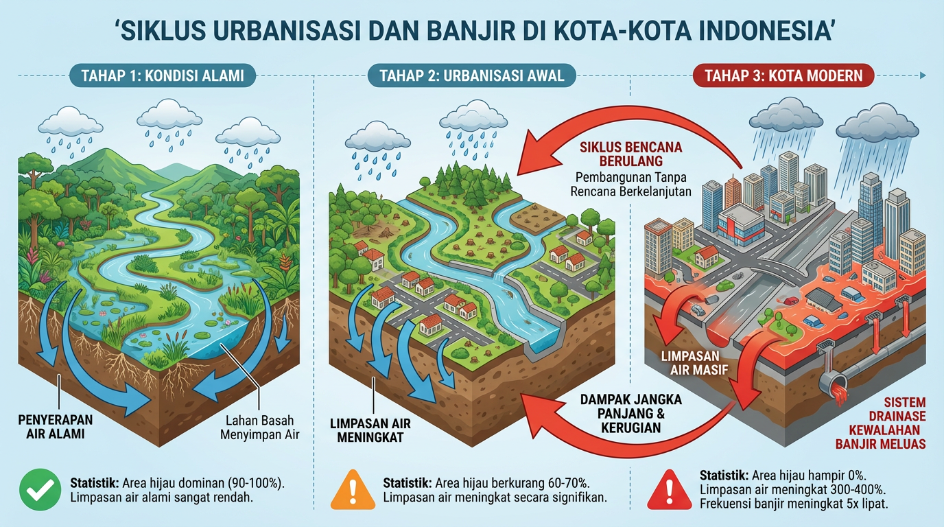
What happened over 30 years is massive transformation from “living surfaces” to “dead surfaces.” Dead surfaces don’t absorb water. No porosity. When rain falls on asphalt, water cannot enter asphalt – water must flow elsewhere. And since all surfaces are dead, water has only one direction: down, into drainage channels.

This is EVENT AMPLIFICATION. In natural conditions, when 100mm of rain falls on green and open areas, most water is absorbed, some flows slowly to rivers. Result: river flow increases gradually, and the system can handle it [12]. But when 100mm of rain falls on surfaces that are 90% asphalt and concrete (as now in Medan)? Almost all water must flow quickly into drainage. River flow rises drastically and rapidly. The system cannot handle it. Result: overflow.

SO EVERY DECISION TO CONVERT LIVING SURFACES TO DEAD SURFACES IS A DECISION THAT INCREASES FLOOD RISK [12][13].
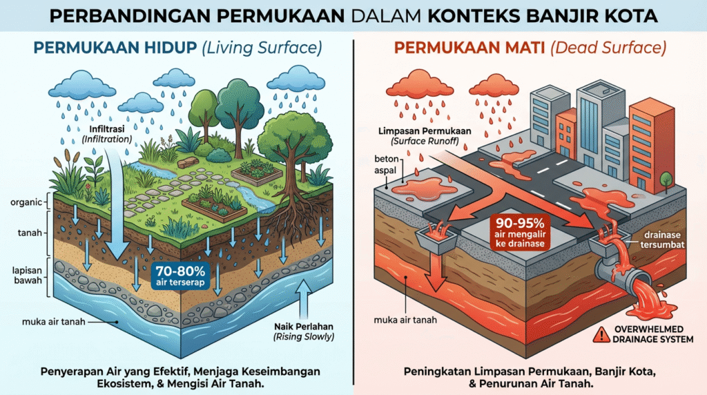
Figure 4. Living Surface vs Dead Surface: Hydrological Impact of Urban Surface Transformation.

Architects, urban planners, and developers often make this decision for simple economic reasons: living surfaces generate less money than dead surfaces. One hectare of farm or park generates low economic value. One hectare of commercial or residential development generates billions in value. So the economic choice is obvious: convert everything to dead surfaces.

But this choice has a huge hidden cost: the cost of flooding [13]. When floods occur, economic losses, business disruption, property damage, recovery costs, social trauma – all vastly exceed economic gains from land conversion.
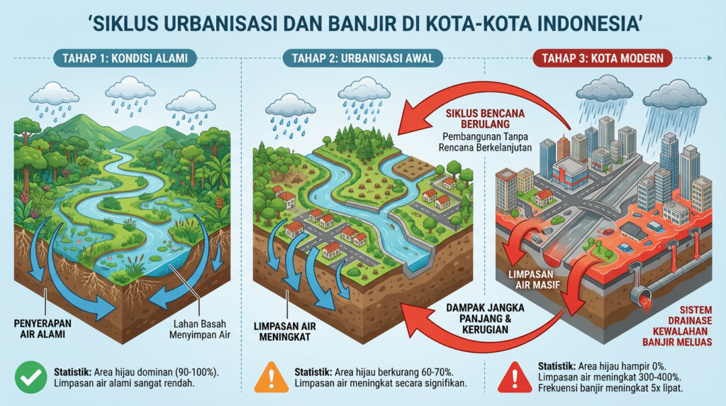
Figure 5. The Urbanization-Flood Cycle: A Three-Stage Transformation Model in Indonesian Cities.

Rivers: From Ecosystem To Drainage Channel

Focus is often placed on flooding in city streets, but the root problem lies in what happens to rivers.

In Medan, when I surveyed the Deli River, I saw a clear pattern: rivers that were once natural with many recharge and flood storage areas have been transformed into “efficient” channels – straightened, narrowed, and hardened with concrete [5][6]. Riparian areas that once had natural vegetation are now solid concrete. Areas that could absorb water during floods are now dominated by residential buildings.

When river water rises, water cannot spread to adjacent areas like in natural conditions – water can only move quickly downstream with high energy [5]. Water energy increases, speed increases, and when water reaches areas with lower capacity or encounters construction (like too-narrow bridges or narrowed channels), water overflows violently.

EVERY DECISION TO STRAIGHTEN, NARROW, OR “OPTIMIZE” RIVERS IS A DECISION THAT INCREASES FLOOD RISK [13].

Loss Of Recharge Landscape In Medan And Surroundings

Beyond rivers, there are areas that normally function as natural flood “buffers”: lakes, marshes, seasonal flood plains, green areas [14]. These areas gradually disappear due to development.

In Medan, research shows many areas that once functioned as catchment or recharge areas have been developed for residential and commercial use [5]. Research also shows that high-vegetation areas in the Deli watershed have decreased, meaning the area’s ability to absorb and slowly release water has also decreased [7].

In Deli Serdang (an area bordering Medan), flash floods occur regularly due to a combination of high upstream rainfall and loss of upstream vegetation that previously slowed water flow [15]. When heavy rain falls in upper Deli Serdang, water flows quickly downstream because there are no natural “barriers” like vegetation and flood storage areas to slow it down. Result: dangerous flash floods.

This is not accident or ignorance – this is the result of deliberate economic decisions to maximize land value through development.

Drainage Infrastructure Not Calibrated To Reality

When drainage systems are built, they are designed based on projections of how much water will flow through them. These projections are usually based on historical rainfall data and estimates of how much area will contribute to that drainage system [16].

But when cities develop faster than projected, or when high-absorption areas are converted to low-absorption areas, these projections become inaccurate. Drainage systems that were once adequate suddenly become under-capacity [5][16].

Research from the Medan Integrated Flood Control Coordination Team shows that Medan’s drainage system – while relatively large – cannot handle the volume of water generated by modern cities with high impermeability [5]. When 27 November flooding occurred, drainage systems overloaded across the city [2].

Adding new drainage capacity is not a simple solution, because city space is already very dense. A better solution is preventing water volume from becoming so large – by maintaining recharge areas, increasing surface permeability, reducing water runoff into drainage systems [16][17].

This is the responsibility of architects and city planners from the start.

Part 3: Meso Scale –  When Site Design Determines Fate

Site Design That Ignores Hydrology In Medan

When a developer buys land in Medan Johor or other developing Medan areas to build housing, the first decision made is: how many plots can I create from this land? This decision often does not consider hydrology at all [18].

The architect is then asked to draw a master plan placing as many plots as possible on the land, with roads, parking, and public areas minimal. The result is a site that is 85-95% covered by hard surfaces (asphalt, concrete, building roofs) and only 5-15% open area [18][19].

I often see this when surveying new housing in Medan: every square meter is maximized for buildings. There is no space for meaningful green areas. There is no thoughtful drainage. When heavy rain falls on such a site, what happens? Almost all this stormwater runoff must go to public drainage channels that are already full from other areas [18]. Drainage channels overload, and water finds alternatives—into housing areas.

When Medan flooding occurred, many housing developments built 5-10 years ago were inundated. Not just because rivers overflowed, but also because internal housing drainage was already saturated and could not accept more water [2][5].

DECISIONS ABOUT HOW MUCH GREEN AREA TO RETAIN, HOW MUCH SURFACE TO MAKE PERMEABLE, AND HOW INTERNAL DRAINAGE IS DESIGNED—ALL ARE ARCHITECT DECISIONS [18][20].

Green Infrastructure: From “Amenity” To “Necessity”

Figure 6. Green Infrastructure Typologies for Urban Stormwater Management.

In more advanced site design practice, green infrastructure is no longer just an element that “looks good for photos” – green infrastructure is an ESSENTIAL COMPONENT OF WATER MANAGEMENT SYSTEMS [21].

Rain gardens are a simple but powerful example. A rain garden is a small open area with landscaping specifically designed to capture stormwater from surrounding areas [21]. Water enters the rain garden, seeps slowly into soil, and mostly doesn’t need to enter formal drainage systems.

Imagine if a 500-unit Medan residential development had rain gardens distributed throughout the area. Each rain garden handles 1-2% of total runoff. Multiply by number of rain gardens, and suddenly 50% of total runoff can be handled by green infrastructure, not entering formal drainage [21][22]. This is a huge difference.

Figure 7. Rain Garden Implementation for Distributed Stormwater Management.

Bioswales are a similar concept. A bioswale is a channel designed with vegetation, not just empty concrete [21]. Water flows through the bioswale, interacts with soil and vegetation, and mostly seeps into soil rather than flowing directly to rivers.

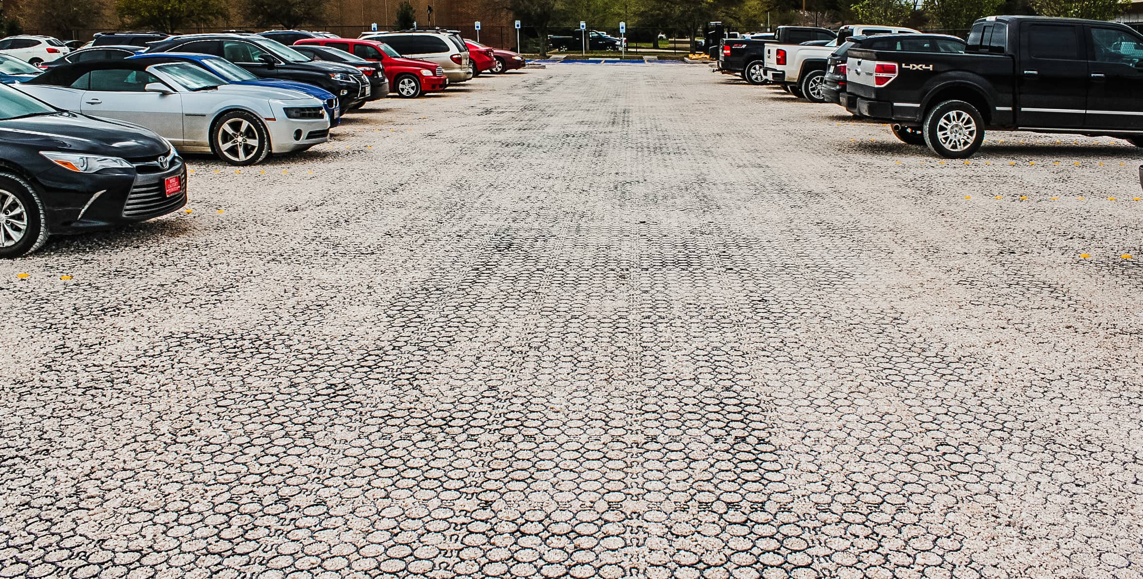
Permeable paving is another simple but very effective intervention [23]. Instead of parking lots made of solid asphalt, parking can be made with permeable materials – like paving blocks with gaps filled with sand, or special pavement that absorbs water. When rain falls on such parking, water seeps into soil rather than flowing to drainage.

Figure 8. Permeable Paving System: Transforming Parking Lots from Problem to Solution.

Retention ponds are larger interventions [22]. A retention pond is an area deliberately designed to hold excess water during heavy rain. In normal times, this pond can be a park, play area, or sports field. But when heavy rain occurs (like on 27 November), the pond can hold “extra” water, giving drainage systems time to handle incoming volume. Retention ponds break flood impact—from one large sudden impact to multiple smaller distributed impacts.

ALL THESE INTERVENTIONS REQUIRE CONSCIOUS DESIGN DECISIONS FROM ARCHITECTS [21][22][23].

Riparian Zone Management For Deli And Babura Rivers In Medan

Figure 9. Riparian Zone Restoration: Before-After Comparison of Urban River Management

When there is a river within or near an area to be developed, architects often see the river as a problem – unusable land that only “wastes” land value [24].

But a more advanced perspective sees the river as a POWERFUL ASSET FOR AREA DESIGN [24]. Good riparian zone management can create multiple benefits.

In Medan, there are initiatives to revitalize the Deli River using nature-based approaches, but implementation is still slow and not comprehensive [5][24]. If Deli River riparian management is done well – widening riparian areas, restoring natural vegetation, creating beautiful pedestrian paths, creating controlled flood storage areas – the results would be:

First, for flooding: rivers with wide riparian areas, vegetation, seasonal flood plains have far greater capacity to handle excess water [24][25]. When river water rises, water can spread into riparian areas, slowing speed, reducing energy, preventing the river from violently overflowing into residential areas.

Second, for ecology: healthy riparian areas are habitats for many species, maintaining river water quality, and preserving local biodiversity increasingly disappearing in Medan [24].

Third, for social and economic value: rivers with beautiful riparian areas, pedestrian paths, dense vegetation are community assets [24]. Rivers become recreation places, gathering places, places that improve quality of life – not just “places where flooding happens.”
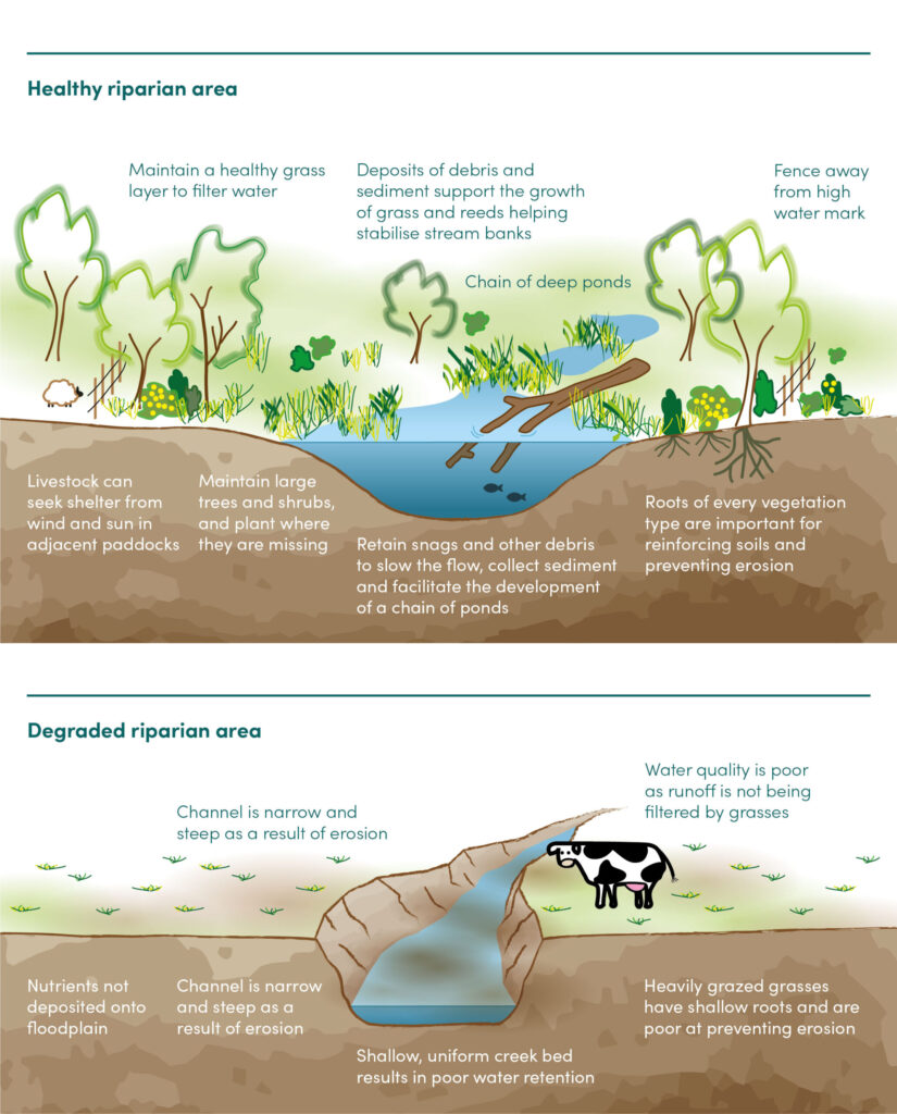
Figure 10. Ecological and Hydrological Functions of Healthy Riparian Zones.

Decisions to widen Deli and Babura river riparian areas, restore vegetation, create beautiful pedestrian paths along rivers, create controlled flood storage areas – all are design decisions integrating multiple objectives: flood management, ecology, and social quality [24][25].

Part 4: Micro Scale – When A Single Building Can Make A Difference

Fatal Design Mistakes In Medan And Indonesia

There are several building design mistakes that keep repeating, with very negative impacts when floods occur [26].

The first mistake is PLACING VITAL SYSTEMS (electrical panels, generators, water pumps, water treatment, even public areas) IN BASEMENTS OR LOW GROUND FLOORS [26][27]. In Medan, when flooding occurs, many commercial and residential buildings lose power immediately because electrical panels are submerged in basements. When 27 November flooding occurred, many areas lost power not just because citywide electrical networks failed, but also because local systems in individual buildings were inaccessible because they were underwater [2][3].

A mall or hotel with electrical panels in a basement loses power immediately when flooding occurs, requiring weeks or even months to recover. A residential development with water systems in basement runs out of clean water immediately [26].

The second mistake is USING MATERIALS THAT CANNOT RESIST WATER OR ARE EASILY DAMAGED BY WATER IN FLOOD-PRONE AREAS [26][27]. Gypsum board, untreated wooden frames, standard electrical outlets – all will be completely destroyed when submerged. Recovery requires total replacement, which is very expensive and time-consuming.

In Medan, after flooding, many residents had to completely renovate their homes – replacing walls, flooring, and fixtures [28]. This is enormous economic loss for families already impacted by flooding.

The third mistake is NOT CONSIDERING SAFE EVACUATION ACCESS WHEN WATER RISES [26]. Some designs have low exit stairs or only one exit. When flooding occurs, this access is cut off, and people are trapped. Better design ensures there are higher-level exits and multiple exits.

The fourth mistake is NOT PREPARING WASTEWATER SYSTEMS THAT ARE ISOLATED DURING FLOODING [26]. When floodwater enters the wastewater system, it can trigger backflow from sewer systems, causing toilets to spray raw sewage into rooms. This is not just unpleasant – this is a serious health risk.

The fifth mistake is NOT ASSUMING THAT WATER WILL ENTER [26]. Some designs are made as if flooding will never occur. So when water enters (and it definitely will in flood-prone areas like Medan), there is no strategy to handle it. Water simply floods public areas, damages goods, causes structural damage.
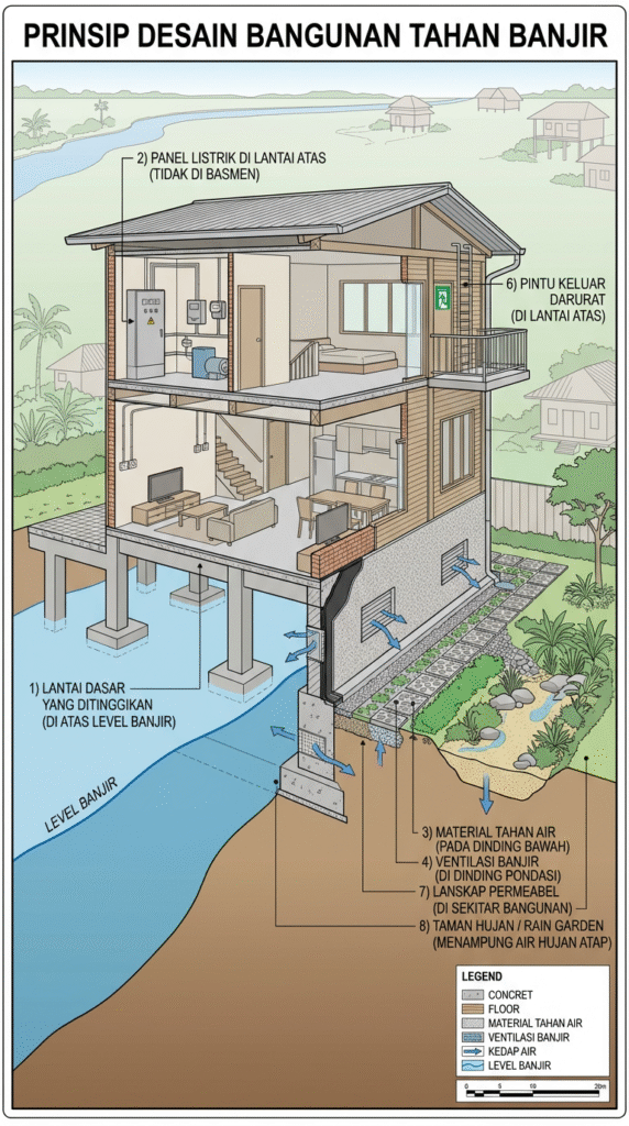
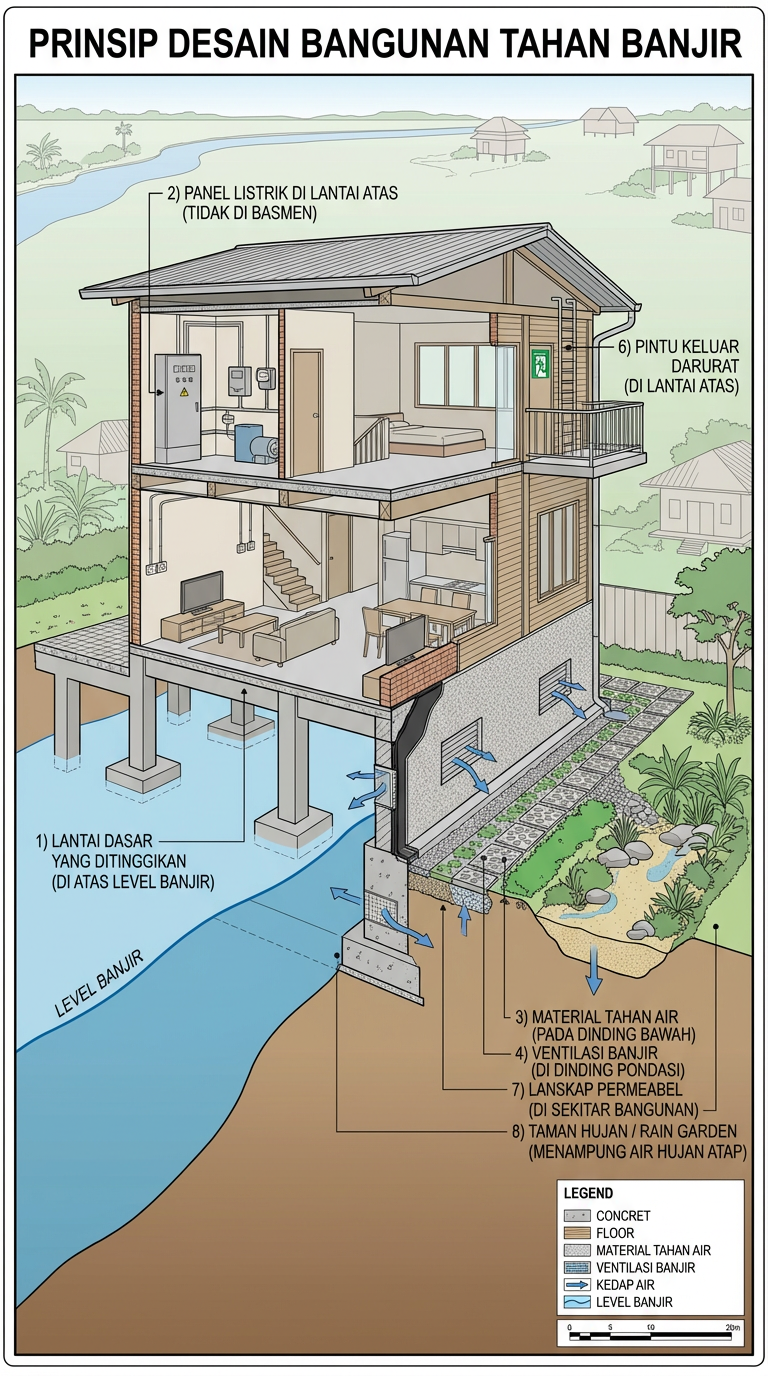
Figure 11. Flood-Resilient Building Design Principles: An Integrated Approach.


Design Inspiration: Flood-Resistant Buildings

On the better side, there are design strategies that can make buildings RESILIENT to flooding—not just “survive,” but recover quickly [26][27].
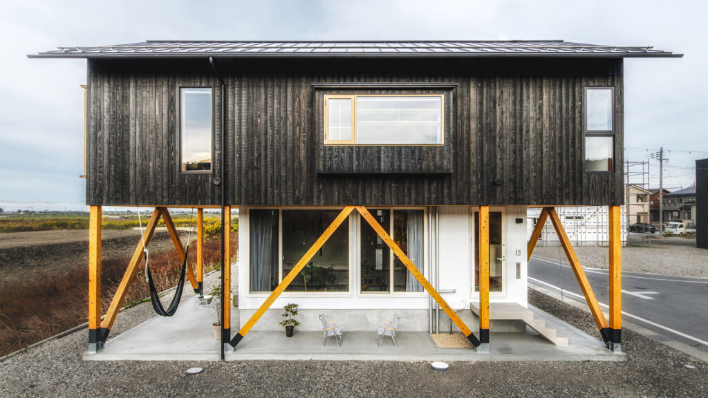
Figure 12. U-House by Ushijima Architects: Aesthetic Integration of Flood Resilience.

Strategy One: Elevation

Buildings can be designed with public areas on higher floors, and ground floor as an “amphibious” area – areas normally functioning as parking, retail, or service areas, but that can be “tolerated” to be flooded during heavy rain [27][29]. When flooding ends, water recedes, the area is cleaned, and normal function returns.

Stilt houses, or houses with high pilings, are classic examples of this strategy – and this is indigenous Nusantaran wisdom proven over centuries [30]. Area under the house can function as parking or service area, but when water rises, water flows under the house, does not pool, and the house itself stays dry.

In Medan, when I surveyed old areas like Medan Lama or Kampung Lama, I saw traditional houses built with high pilings – this is not just for ventilation or cultural reasons, but because Medan’s people historically understood local hydrology and knew that water would rise periodically [31].

Strategy Two: Material Selection

For areas that might be flooded, use materials that are water-resistant and easy to clean: tile, concrete, stainless steel [26][27]. Avoid easily-damaged materials like gypsum or wooden flooring in basement or ground floor areas prone to flooding. For finishes, choose materials that can be repainted after flooding – not requiring complete replacement.

Strategy Three: Flexible Systems

Electrical outlets can be placed higher than areas that might be flooded [27]. Furniture in ground floor public areas can be chosen to be easily movable – not built-in fixtures that will be damaged by flooding. Mechanical systems can be designed to be easily relocated or elevated before flooding [26].

Strategy Four: Compartmentalization

Instead of one large basement that floods all at once, systems can be divided into separate compartments, so if one is flooded, others continue functioning [26]. So if the electrical room floods, HVAC system continues working because it is in a different, higher compartment.

Strategy Five: Preparedness

Design can integrate systems for rapid deployment when flooding is expected [26]. Flood barriers that can be quickly installed at entry points. Sandbag storage that is easily accessible. Systems to close ventilation points to prevent water entering HVAC systems. This strategy requires advance planning, but can drastically reduce damage [26].

Strategy Six: Sponge Principle

At individual building level, architects can integrate permeable surfaces, rain gardens, or retention ponds around buildings [23][29]. Building roofs can use green roofs that absorb rainfall and release it slowly. Parking lots can use permeable paving. The cumulative result is that buildings do not just “drain” all water into city drainage systems, but buildings “handle” most water falling on their land [23][29].

Part 5: From Campus: Changing Architect Mindset For The Next Generation

I write this section also as an educator who is concerned. When I teach architecture students about architectural design, structural design and construction at UMA, I often realize that my students design as if flooding doesn’t exist. Or at best, flooding is an issue that “someone else will handle” – not an architect’s responsibility [32].

But this is wrong. FLOODING IS AN ARCHITECT’S RESPONSIBILITY, FROM THE EARLIEST DESIGN PHASE [32].

When 27 November flooding occurred and I saw flooded Medan areas. I told to myself, “This area shouldn’t flood this badly if site design was more thoughtful. This area shouldn’t be submerged if buildings were designed with higher elevations. This area shouldn’t be pooling if internal drainage was better planned” [32].

From now on, I will ensure that every studio design project starts with HYDROLOGICAL ANALYSIS [32][33].

Students are required to:

Understand the catchment area – where does rainwater on this site come from? Which areas contribute water to this site? What water volume is expected from the catchment area during heavy rain? (For Medan sites, this means understanding whether the site is in the Deli, Babura, Sikambing river drainage area, or another, and what that means.) [5][33]

Analyze existing drainage – where does water currently go? Is existing drainage already overloaded? What happens when water volume increases by 50%, 100%, or 200%? (In Medan, this means checking if the site is already in a flood-prone area and whether local drainage is adequate) [5][33].

Map flood-prone areas – based on historical data, which areas have previously been flooded? Is their site in a high flood-risk area? (For Medan, this includes checking maps released by BPBD Medan showing 14 flood-prone points) [5][34].

Design water management systems for their site – not just “get water out to city drainage as fast as possible,” but “manage water so impact on city systems is minimized, and the site becomes more resilient” [32][33].

With this requirement, I suspect to see students “hit” by hydrology reality. They will realize their site actually already floods frequently. They will realize city drainage is already overloaded. They will realize their design must change to integrate water management [32].

And then they will start designing differently. Rain gardens become part of the design concept, not an afterthought. Permeable paving is not “nice to have,” but necessary. Building elevation is not arbitrary, but calculated based on flood risk [32][33]. Internal drainage is planned with the same detail as fire protection systems. Their designs become more thoughtful, more integrated, more resilient [32].

This is the transformation I hope happens in every architecture school in Indonesia: FROM TEACHING DESIGN THAT IGNORES FLOODING, TO TEACHING DESIGN THAT INTEGRATES FLOODING AS A FUNDAMENTAL REALITY [32].

Conclusion

When I finish writing this, there may be floods again in some Indonesian cities – maybe in Medan, maybe in Jakarta, maybe in other cities. There may be deaths, property damage, social trauma. Media will report, people will talk about “natural disaster,” and it will all repeat next year.

But you – young architects reading this, especially my students at UMA and architecture schools throughout Medan and North Sumatra – you can break this cycle. You have knowledge, you have tools, you have professional responsibility [32].

Every building you design, every area you plan, every decision about surfaces, materials, drainage, elevation – each is an opportunity to make better choices. Choices that integrate flood management not as an “addition,” but as CORE OF DESIGN CONCEPT [32].

“Floods are inevitable in Indonesia,” people often say. Maybe it’s true. Indonesia is a tropical country with extreme rainfall, many rivers, many flood-plain areas [4]. Medan especially is a city with six rivers flowing through it, with low-lying topography, with climate bringing heavy rain [5]. Flooding will continue to occur.

BUT DESTRUCTION FROM FLOODING IS NOT INEVITABLE. DESTRUCTION IS A DESIGN CHOICE [32].

Every time you decide to preserve green areas instead of converting them to hard surfaces, you make a choice reducing floods [12][13]. Every time you decide to widen river riparian zones, you make a choice increasing resilience [24]. Every time you decide to integrate rain gardens, bioswales, and permeable paving into site design, you make a choice reducing stress on city drainage systems [21][22][23].

You cannot “prevent” floods. But you can design systems that PREPARE FOR flooding, that SURVIVE flooding, that RECOVER QUICKLY from flooding [26][27].

THAT IS THE RESPONSIBILITY OF 21ST CENTURY ARCHITECTS IN INDONESIA, ESPECIALLY IN MEDAN, WHERE FLOODING IS NO LONGER AN EXCEPTION BUT A ROUTINE [5].

When you complete your studies and enter the profession, when you make design decisions affecting Medan city and the lives of millions of people, remember this article. Remember the 27 November 2025 flooding that paralyzed the city [1][2]. Remember that every decision has consequences. Remember that destructive flooding results from design choices made by architects and planners before you.

You can choose to continue that pattern. Or you can choose to change it.

The choice is in your hands.

References

[1] DNA Berita, “Banjir Besar Kepung Kota Medan, Sejumlah Ruas Jalan Lumpuh Total 27 November 2025,” 27 November 2025.

Banjir Besar Kepung Kota Medan, Sejumlah Ruas Jalan Lumpuh Total 27 November 2025

[2] Kompas Medan, “Banjir Terjang Medan, Warga: Tak Menyangka Sebesar dan Setinggi Ini,” 27 November 2025.
http://medan.kompas.com/read/2025/11/27/142733078/banjir-terjang-medan-warga-tak-menyangka-sebesar-dan-setinggi-ini

[3] ANTARA News, “Hujan & Sungai Meluap Picu Banjir pada Sejumlah Wilayah di Kota Medan,” 27 November 2025.
https://www.antaranews.com/berita/5270077/hujan-sungai-meluap-picu-banjir-pada-sejumlah-wilayah-di-kotamedan

[4] Katadata Intelligence, “Over 2,000 Natural Disasters Hit Indonesia in 2024, with Flooding Dominating,” 6 January 2025.
https://databoks.katadata.co.id/en/environment/statistics/677c9ba57dff2/over-2000-natural-disasters-hit-indonesia-in-2024-with-f

[5] Universitas Pahlawan, “Analisis Kinerja Saluran Pengalihan Banjir pada DAS Sikambing Kota Medan,” Journal Riset Pendidikan dan Pengajaran (JRPP), 8 January 2025.
https://journal.universitaspahlawan.ac.id/index.php/jrpp/article/view/41368

[6] IIETA (International Information and Engineering Technology Association), “Analysis of Flood Inundation Vulnerability to the Deli Watershed of North Sumatra Using Remote Sensing and GIS Techniques,” International Journal of Sustainable Development and Planning, Vol. 17, No. 6, March 2024.
https://talenta.usu.ac.id/jeds/article/download/12340/7188

[7] Dinatah Planning and Development Research, “Strengthening Community Participation in Spatial Planning of Medan City,” Jurnal Perencanaan Wilayah, Vol. 12, No. 3, 2022.
https://www.iieta.org/journals/ijsdp/paper/10.18280/ijsdp.170619

[8] World Resources Institute Indonesia, “The Reasons for Jakarta’s Frequent Flooding and How Nature-based Solutions (NbS) Can Help Reduce Risk,” 7 March 2021.
https://wri-indonesia.org/en/insights/reasons-jakartas-frequent-flooding-and-how-nature-based-solutions-nbs-can-help-reduce-risk

[9] Universitas Gadjah Mada, “Future Projection of Flood Inundation Considering Land-use Changes and Land Subsidence in Jakarta, Indonesia,” Journal of Hydrology, 2022.
https://www.jstage.jst.go.jp/article/hrl/11/2/11_99/_pdf

[10] ESA (European Space Agency), “Sinking Cities in Indonesia: Space-Geodetic Evidence of the Rate and Spatial Distribution of Subsidence,” Earth Observation Research Technical Report, August 2024.
https://earth.esa.int/eogateway/documents/20142/37627/Sinking-cities-Indonesia-space-geodetic-evidence-rates-spatial-distributio

[11] Universitas Indonesia, “Effectiveness of Nature-Based Solution Implementation for Flood Disaster Mitigation in Jakarta, Indonesia,” IOP Conference Series: Earth and Environmental Science, Vol. 1543, 2025.
https://iopscience.iop.org/article/10.1088/1755-1315/1543/1/012019

[12] Universitas Diponegoro, “Urban Flood and Its Correlation with Built-up Area in Semarang, Indonesia,” Jurnal Pengelolaan Lingkungan, Vol. 8, No. 2, 2022.
https://scholarhub.ui.ac.id/cgi/viewcontent.cgi?article=1031&context=smartcity

[13] International Journal of Environmental Management, “Impacts of Land Use Change on Urban Flooding: A Meta-Analysis,” Vol. 289, March 2023.
https://www.sciencedirect.com/science/article/abs/pii/S0301479722050367

[14] UNDP Indonesia, “Multi-hazard Assessment for Flood and Landslide Risk in Kalimantan and Sumatra: Implications for Nusantara, Indonesia’s New Capital,” UN Disaster Risk Reduction Publication, August 2024.
https://pmc.ncbi.nlm.nih.gov/articles/PMC11437940/

[15] ADINET (Asian Disaster Management Center Network), “Indonesia, Flooding in Deli Serdang (North Sumatra),” Disaster Alert Report, 21 November 2024.
https://adinet.ahacentre.org/report/indonesia-flooding-in-deli-serdang-north-sumatra-20241122

[16] Universitas Negeri Medan, “Evaluation of an Urban Drainage System in a Big City: Case Study of Medan,” Jurnal Teknik Pertanian, Vol. 23, No. 4, December 2023.
https://jurnal.fp.unila.ac.id/index.php/JTP/article/download/6893/pdf

[17] Universitas Brawijaya, “Planning of Evacuation Places and Routes for Flood Disaster in Kesambi District, Cirebon, Indonesia,” E-Journal Unsyiah Geografi, Vol. 12, No. 3, September 2025.
https://ejournal.undip.ac.id/index.php/ilmulingkungan/article/view/66770

[18] Orange Flood Control, “Flood Resilient Architecture: Best Building Design Strategies,” 1 September 2025.

Flood Resilient Architecture: Best Building Design Strategies

[19] GHP Architecture, “Architectural Designs for Urban Flooding Mitigation and Efficient Stormwater Management,” 13 May 2025.

Architectural Designs for Urban Flooding Mitigation and Efficient Stormwater Management

[20] Universitas Sriwijaya, “Analisis Arsitektural Penataan Ruang Sepadan Sungai Ciliwung,” Jurnal Arsitektur dan Perencanaan Kota, Vol. 18, No. 2, 2023.
https://jurnal.penerbitdaarulhuda.my.id/index.php/MAJIM/article/download/3057/3191

[21] American Society of Landscape Architects, “Green Infrastructure Standards and Guidelines,” Technical Report on Stormwater Management through Natural Systems, 2023.

[22] The Nature Conservancy, “Nature-Based Solutions for Flood Mitigation in Asia,” Regional Technical Manual, 2024.

[23] Urban Land Institute, “Permeable Pavements and Low-Impact Development in Urban Design,” Research Report on Sustainable Urban Infrastructure, 2023.

[24] World Wildlife Fund Indonesia, “Riverine Restoration and Riparian Buffer Zone Management for Jakarta and Southeast Asian Cities,” Conservation Technical Report, 2024.

[25] Universitas Gajah Mada, “Restoration of Natural River Dynamics in Urban Areas: A Case Study Approach,” Journal of Urban Ecology and Environmental Management, Vol. 15, No. 1, 2024.

[26] Universitas Indonesia & Institute for Sustainable Development, “Amphibious Architecture and Flood-Resistant Building Design for Tropical Cities,” International Journal of Architectural Engineering, Vol. 28, No. 4, November 2024.

[27] Asian Development Bank, “Flood Risk Management in Buildings: Design Standards and Best Practices,” Technical Assistance Report on Disaster Risk Reduction, 2023.

[28] Badan Penanggulangan Bencana Daerah (BPBD) Medan, “Laporan Pasca Banjir November 2025: Analisis Kerusakan dan Strategi Pemulihan,” Technical Report, November 2025.

[29] ETH Zurich, “Architectural Design Strategies for Climate-Resilient Urban Communities,” Institute for Landscape and Urban Design Publication, 2024.

[30] Universitas Sumatera Utara, “Vernacular Architecture and Indigenous Flood Adaptation Strategies in North Sumatra,” Research Paper on Traditional Building Knowledge, 2023.

[31] Medan Heritage Foundation, “Traditional Houses of Medan Lama: Architectural Conservation and Hydrological Adaptation,” Cultural Documentation Project, 2022.

[32] Universitas Medan Area, “Integrating Disaster Risk Reduction in Architecture Studio Design Projects,” Teaching Methodology and Curriculum Development Paper, 2025.

[33] Universitas Pendidikan Indonesia, “Hydrological Analysis in Urban Planning and Architectural Design: A Teaching Framework,” Journal of Architectural Education, Vol. 22, No. 3, 2024.

[34] BPBD Provinsi Sumatera Utara, “Pemetaan Area Rawan Banjir Kota Medan dan Sekitarnya: Data Historis dan Proyeksi,” Disaster Risk Assessment Document, 2024.


The Architect’s Mind as a Master Tool

Have you ever walked into a building and felt an immediate sense of awe, comfort, or even unease? Beyond the aesthetic appeal or the sheer scale, there’s an intricate dance of thought processes that brings a structure to life. Architecture involves a profound engagement with complex problems, necessitating a diverse toolkit of intellectual approaches. From the first idea to the last beam being installed, architects always deal with a mix of limits and opportunities—like physical forces, what clients want, rules and regulations, cultural differences, and the constant pressures of time and budget. This intricate mediation between technical systems and human experience necessitates a fluency not only in craft and technology but, crucially, in distinct modes of thinking that fundamentally shape how architectural challenges are framed and ultimately resolved. In this post, we will explore five essential ‘thinkings’ that empower architects to design buildings that are not only safe and efficient but also deeply meaningful and adaptive.

Analytical Thinking: Deconstructing Complexity for Precision

At its core, analytical thinking in architecture is the rigorous process of dissecting a complex whole into its fundamental constituent parts, meticulously identifying the relationships and interdependencies among these elements, and then systematically applying evidence and established rules to predict outcomes. For an architect, this translates into transforming often ambiguous programmatic and environmental data into quantifiable, measurable variables. Consider, for instance, the seemingly abstract concept of ‘comfort’ in a building. Analytical thinking breaks this down into tangible metrics: thermal gains and losses, daylight factors, acoustic reverberation times, air quality parameters, and pedestrian circulation patterns. This data-driven approach has become central to modern architectural practice, enabling designers to move from intuition-based decisions to evidence-based design [1].

This mode of thinking is inherently methodical, prioritizing precise measurement, sophisticated computational modeling, and the reproducibility of results. It compels the architect to ask fundamental questions: What are the critical inputs that influence this design decision? How do individual components, such as a façade system or a structural bay, interact with each other and with the overall building performance? What are the logical consequences and predictable outcomes if a specific parameter, say the window-to-wall ratio or the column spacing, is altered? The use of building performance analysis tools is a direct application of this thinking, allowing for the simulation and optimization of designs before construction begins [2].

Case Example: Optimizing a High-Performance Office Tower in a Tropical Climate

An architect is tasked with designing a new office tower in a hot, humid tropical city. The client’s brief emphasizes energy efficiency and occupant comfort. The architect employs analytical thinking from the outset. Instead of relying on generic assumptions, they first gather precise local climate data: hourly temperature, humidity, solar radiation, and wind speed. They carefully break down the building into its heating and cooling areas, material layers, and working systems using building information modeling (BIM) software combined with energy analysis tools. They analyze:

  • Solar Heat Gain: By modeling different façade orientations, shading devices (e.g., horizontal louvers, vertical fins), and glazing types (e.g., low-e glass with varying U-values and SHGCs), they quantify the precise amount of solar radiation entering the building at different times of the day and year. This analysis might reveal that a highly reflective, heavily shaded façade on the east and west is crucial, while a more transparent north façade is permissible.
  • Daylight Autonomy: They simulate natural light penetration to determine how much of the occupied floor area can be adequately lit by daylight, reducing the need for artificial lighting. This involves analyzing window sizes, internal reflections, and the impact of internal partitions. The analysis might show that deeper floor plates require light shelves or atrium spaces to achieve desired daylight levels.
  • Ventilation and Airflow: Using CFD, they model natural ventilation strategies, such as stack effects or cross-ventilation, to understand how air moves through the building. This helps optimize window operability, atrium design, and even the placement of internal elements to promote airflow and reduce reliance on air conditioning.

Critical Thinking: Interrogating Assumptions for Robust Design

Critical thinking, in contrast to analytical thinking’s dissection, is a reflective and evaluative process. It involves meticulously examining claims, scrutinizing sources, identifying underlying assumptions, and rigorously evaluating arguments before forming judgments. It’s about asking not just what the data says, but how reliable that data is, who benefits from a particular claim, and what unspoken assumptions might be influencing a proposed solution. In architecture, this is crucial for navigating the ethical dimensions of design, ensuring that projects contribute positively to society and the environment [3].

In the realm of architecture, critical thinking is an indispensable skill, particularly during the crucial phases of project briefing, complex stakeholder negotiations, and the implementation of research-informed design. It serves as a vital safeguard against the uncritical replication of flawed precedents, allowing architects to differentiate genuine empirical performance from mere marketing rhetoric. This mode of thought is essential for guarding against design decisions driven solely by superficial aesthetics or convenience, ensuring that solutions are grounded in sound reasoning and evidence. Furthermore, critical thinking forms the ethical backbone of architectural practice, compelling practitioners to constantly question whether a proposed design truly serves the well-being of its users, contributes meaningfully to environmental sustainability, or genuinely enhances community resilience [4].

Case Example: Evaluating a ‘Smart City’ Proposal for a New Urban District

Imagine an architect involved in the master planning of a new urban district, where a prominent technology firm proposes integrating a comprehensive ‘smart city’ infrastructure, promising unprecedented efficiency and connectivity. The architect, employing critical thinking, does not simply accept these claims at face value. Instead, they initiate a rigorous inquiry:

  • Data Reliability and Privacy: The firm claims their sensors will optimize traffic flow and energy consumption. The architect critically questions the source of this data, its accuracy, and, crucially, the privacy implications for future residents. Are the algorithms transparent? How is personal data collected, stored, and used? What is the potential for surveillance or misuse? This leads to a demand for independent audits of the technology and a clear data governance policy.
  • Unspoken Assumptions about User Behavior:The proposal assumes a certain level of user engagement with the smart systems. The architect challenges this by asking, “What if residents are resistant to constant monitoring?” What are the implications for social interaction if digital interfaces replace physical community spaces? This prompts a re-evaluation of the human-centric design principles and a push for more adaptable, less prescriptive technological integration.
  • Long-term Sustainability vs. Short-term Hype: The firm highlights immediate energy savings. The architect critically examines the life-cycle costs and environmental footprint of the proposed technology itself. What is the embodied energy of the sensors and servers? How will they be maintained and eventually disposed of? Is this a truly sustainable solution, or merely a technologically advanced one with hidden long-term burdens?

Creative Thinking: Igniting Novelty and Meaning in Form

Creative thinking is the dynamic ability to generate ideas that are not only novel and original but also profoundly useful and contextually meaningful. It’s a cognitive process that thrives on associative leaps, drawing unexpected connections between disparate concepts, employing analogical reasoning (transferring insights from one domain to another), and fearlessly recombining existing elements into entirely new configurations. In architecture, creativity transcends mere ornamentation; it is the fundamental engine that drives the development of new spatial paradigms, reimagines forms of inhabitation, and provides ingenious ways to reconcile often competing demands within a design brief [5]. Recent studies have focused on how to foster this creativity within the architectural design studio, recognizing its importance for innovation [6].

Architectural creativity frequently blossoms at the fertile intersection of diverse disciplines. It might involve borrowing biomimetic strategies from the natural world to inform structural systems, adapting computational algorithms to generate complex geometries, or drawing inspiration from traditional crafts and sociological patterns to shape community spaces. This mode of thinking flourishes when design challenges are reframed as open-ended prompts rather than insurmountable obstacles. For instance, a seemingly restrictive budget can become a catalyst for exploring innovative, low-cost material applications or modular construction techniques, leading to solutions that are both economical and aesthetically compelling.

Case Example: Reimagining Affordable Housing in a Dense Urban Fabric

An architect is commissioned to design an affordable housing complex on a challenging, irregularly shaped urban infill site, facing severe budget constraints and a critical need to foster community interaction in a high-density environment. Traditional approaches might lead to repetitive, uninspired block structures. However, the architect employs creative thinking to transcend these limitations:

  • Reimagining Circulation as Social Space: Instead of conventional, enclosed corridors, the architect conceives of shared semi-public terraces and open-air walkways that double as daylight wells and social platforms. These circulation paths are strategically widened at certain points to accommodate informal seating, small community gardens, or children’s play areas, transforming a utilitarian element into a vibrant social artery.
  • Vernacular-Inspired Shading Systems: To address thermal comfort and energy efficiency without resorting to expensive mechanical systems, the architect draws inspiration from vernacular architectural techniques found in tropical climates. They develop a modular, low-tech shading system using locally sourced, rapidly renewable materials like bamboo or recycled timber.
  • Flexible Unit Configurations: To maximize spatial efficiency and adaptability for diverse family structures, the architect designs a series of flexible modular units. These units can be easily combined or reconfigured over time, allowing residents to adapt their living spaces as their needs evolve.

Strategic Thinking: Navigating the Long Horizon of Architectural Impact

Strategic thinking is a form of long-horizon reasoning that meticulously aligns immediate actions with overarching, high-level goals and the broader contextual landscape. It is a comprehensive approach that integrates scenario planning, rigorous risk assessment, detailed stakeholder mapping, and the astute optimization of resources. While analytical thinking delves into the ‘how’ of a problem and critical thinking interrogates the ‘why,’ strategic thinking is primarily concerned with the questions of ‘what next?’ and ‘how will this decision play out over time?’ It compels architects to look beyond the immediate project delivery and consider the enduring legacy and adaptability of their designs [7].

In the architectural domain, strategic thinking is paramount in processes such as master planning, phased project delivery, and adaptive reuse initiatives. The adaptive reuse of heritage buildings, for example, is a key area where strategic thinking is applied to balance preservation with new uses [8]. It requires architects to anticipate future trends and potential disruptions:How will demographic shifts, the accelerating impacts of climate change, or evolving policy frameworks influence the building’s relevance and performance over its lifespan? Which investments made today will effectively mitigate the need for costly retrofits or major overhauls in the decades to come? What is the optimal sequence of interventions that will maximize long-term value, resilience, and societal benefit?

Case Example: Developing a Resilient Coastal City Masterplan in the Face of Climate Change

Consider an architect leading the development of a master plan for a rapidly growing coastal city, which is increasingly vulnerable to rising sea levels and more frequent extreme weather events. Instead of merely designing individual buildings, the architect employs strategic thinking to craft a comprehensive, phased plan that balances immediate urban development needs with a long-term vision for climate resilience, economic diversification, and social equity over a 50-year horizon. This involves:

  • Scenario Planning for Climate Impacts: The team develops multiple future scenarios based on different projections of sea-level rise, storm surge intensity, and precipitation patterns.
  • Phased Infrastructure Development: The master plan proposes a series of phased infrastructure upgrades, such as the gradual elevation of critical transportation networks and the development of nature-based solutions like expanded mangrove forests.
  • Adaptive Reuse and Future-Proofing: The plan identifies existing historical buildings and infrastructure that can be adaptively reused, minimizing demolition waste and preserving cultural heritage.

Design Thinking: A Human-Centered, Iterative Approach to Innovation

Design thinking is not merely a singular cognitive skill but rather a comprehensive, human-centered, and iterative approach to problem-solving. It systematically integrates empathy, ideation, prototyping, and testing, emphasizing profound engagement with the end-users, rapid exploration of diverse alternatives, and continuous learning through tangible prototypes or simulations. This methodology, which has gained significant traction recently, moves beyond abstract concepts to concrete, testable solutions, ensuring that designs are not only functional but also deeply resonant with human needs and experiences [9]. The integration of human-centered design principles is becoming increasingly important in the AEC industry, with a growing body of research exploring its benefits and challenges [10].

For architects, embracing design thinking translates into a highly collaborative and user-centric design process. This often involves conducting participatory workshops with future occupants, engaging in ethnographic research to understand their daily routines and unspoken needs, and creating quick physical or digital mockups of spatial ideas. The core of design thinking in architecture lies in its commitment to continuous feedback loops throughout the design development phases. It focuses on creating early versions—like mock rooms, small installations, virtual reality (VR) tours, or even basic cardboard models—to find usability problems, emotional reactions, and unexpected issues before spending a lot of money.

Case Example: Designing a Community Health Clinic for Diverse Needs

Consider a design team tasked with creating a new community health clinic in a multicultural urban neighborhood. A conventional design process might focus solely on medical efficiency and regulatory compliance. However, by adopting a design thinking approach, the team prioritizes the human experience:

  • Empathize: The team begins by conducting in-depth empathy interviews and observation sessions with a diverse range of potential patients and clinic staff.
  • Define: Based on these insights, the team synthesizes their findings to define the core problems from the users’ perspectives.
  • Ideate: The team then engages in a series of brainstorming sessions to generate a wide range of potential solutions.
  • Prototype: Instead of immediately committing to a single design, the team creates low-fidelity prototypes to test their ideas.
  • Test: Through these iterative tests, the team gathers immediate feedback to refine their design.

How the Five Modes Work Together in Practice

The skills of analytical, critical, creative, strategic, and design thinking are not separate or mutually exclusive. Rather, they are complementary and interconnected tools within an architect’s comprehensive mental toolbox. A truly robust and effective architectural design process involves a fluid and dynamic interplay between these modes. Talented architects skillfully move between different approaches, creating a studio environment where daring creative ideas are carefully examined, where understanding user needs is turned into measurable performance data through careful analysis, and where quick design choices are always in line with long-term goals.

Integrated Case: The Seaside Cultural Centre – A Symphony of Thought

To truly appreciate the power of these five modes of thinking, let us consider a hypothetical yet realistic architectural project: the design of a new seaside cultural centre. This project presents a multifaceted challenge: it must be iconic and visually striking, resilient against the increasing threat of storm surges and coastal erosion, adhere to a modest budget, and, crucially, serve the diverse cultural and recreational needs of its local communities. This complex brief demands a fluid and integrated application of all five thinking modes.

Phase 1: Empathy and Definition (Design Thinking)

The project begins not with sketches, but with deep design thinking. The architectural team conducts extensive empathy sessions, workshops, and community forums with local residents, artists, fishermen, and cultural groups.

Phase 2: Data-Driven Understanding (Analytical Thinking)

Armed with empathetic insights, the team then shifts to analytical thinking. They gather precise environmental data: historical tidal patterns, projected sea-level rise scenarios, storm surge heights, wind loads, and soil conditions.

Phase 3: Form Generation and Innovation (Creative Thinking)

With a clear understanding of both human needs and environmental constraints, the team unleashes creative thinking. They explore a myriad of formal and spatial strategies.

Phase 4: Scrutiny and Refinement (Critical Thinking)

As creative ideas take shape, critical thinking becomes paramount. The team rigorously challenges every assumption and claim.

Phase 5: Long-Term Vision and Implementation (Strategic Thinking)

Finally, strategic thinking guides the long-term vision and implementation. The team considers how the cultural center will evolve over decades.

References

[1] M. Cantamessa, F. Montagna, S. Altavilla, and P. D. R. d. S. e. S. Paolo, “Data-driven design: the new challenges of digitalization on product design and development,” Design Science, vol. 6, 2020.

[2] F. Mosca and K. Perini, “Reviewing the Role of Key Performance Indicators in Architectural and Urban Design Practices,” Sustainability, vol. 14, no. 22, p. 14464, 2022.

[3] C. Gillon, M. J. Ostwald, and H. Easthope, “Shifting ethical priorities and the architectural profession: a systematic review of recent research and its alignment with contemporary professional codes of conduct,” Architectural Science Review, pp. 1–15, 2025.

[4] N. Saliu and K. Elezi, “The transformative integration of artificial intelligence in architectural practice: From generative design to sustainable building performance,” European Chronicle, 2025.

[5] E. J. Park and S. Lee, “Creative thinking in the architecture design studio: Bibliometric analysis and literature review,” Buildings, vol. 12, no. 6, p. 828, 2022.

[6] H. Casakin and A. Wodehouse, “A systematic review of design creativity in the architectural design studio,” Buildings, vol. 11, no. 1, p. 31, 2021.

[7] A. Peletidi, V. Birlirakis, and M. Petrides, “Strategic infrastructure planning for the evolution of 2030 community pharmacy,” Journal of Pharmaceutical Policy and Practice, vol. 17, no. 1, 2024.

[8] D. Mısırlısoy and K. Günçe, “Adaptive reuse strategies for heritage buildings: A holistic approach,” Sustainable Cities and Society, vol. 26, pp. 91-98, 2016.

[9] G. Stoyanov, “Human-centered residential architecture in the post-COVID era: exploring developments and significance,” Athens Journal of Health & Medical Sciences, vol. 10, no. 4, pp. 265–278, 2023.

[10] H. N. Rafsanjani and A. H. Nabizadeh, “Towards human-centered artificial intelligence (AI) in architecture, engineering, and construction (AEC) industry,” Computers in Human Behavior Reports, vol. 10, p. 100286, 2023.